THE
IMPORTANCE AND ROLE OF THE LAKES OF KAZAKHSTAN IN THE DEVELOPMENT OF TOURISM
Dzhangeldina
D.I.
Candidate of Pedagogy,
Associate Professor
Kazakh National Pedagogical
University named after Abay
Almaty (Kazakhstan)
Beykitova
A.N.
MA in Geography, Lecturer
Kazakh National Pedagogical
University named after Abay
Almaty (Kazakhstan)
The Republic of Kazakhstan, located at the
centre of Eurasia, is one of the countries having natural beauty. The ninth largest country in
the world by land area, it is also the world's largest landlocked
country; its territory of 2,727,300 square kilometres is larger than Western Europe. It is neighbored
from the north by Russian Federation, from the
south-east by People’s Republic of China, from the east Kyrgyzstan and Uzbekistan,from the west by Turkmenistan,
and also borders on a large part of the Caspian Sea.
The biggest seas
and lakes in the world such as the
Caspian Sea, Aral Sea, Lake Balkhash, Lake Alakol, Lake
Burabay,Tengiz-Korgalzhyn Lakes, Lake Shortandy,Big Almaty Lake, Small Almaty
Lake, Lake Markakol, Lake Issyk,Kolsay Lakes etc. are located at the
territory of Kazakhstan.
The number of
population is more than 16 million people. The highest point is Khan Tengri. It
is 6,995 m above sea level. The lowest point is Karakiya Depression (132 m
below sea level). 99 of 110 chemical
elements of Periodic Table have been discovered in Kazakhstan. Some 85,022
(large and small) rivers and streams flow on the territory of Kazakhstan. There
are 48,262 lakes and 168 water reservoirs in Kazakhstan.There are 2,724
glaciers with the volume of more than 100 km3 . The deserts occupy 44% of the territory of
Kazakhstan, semi-deserts occupy 17% of the territory, steppes occupy 26% of the
territory and forest-steppe zones occupy 2.5% of the territory. Total area of
forests is 10 million ha. There are 10 nature reserves and 6 national parks in
Kazakhstan.
The Lake Alakol – a lake located in the eastern
part of the Balkhash-Alakol hollow in the south-east part of Kazakhstan. Its
elevation is 347 m above sea level. It is situated between Tarbagatay on the
north and DzhungarAlatau on the south. On the east the
Lake is connected to Dzhungarian Gate (a narrow valley). The Lake together with
the Lake Sasykkol, Uyaly, Zhalanashkol and others, which are shallower, form
the Alakol Lake system. The area of the Lake is 2,200-2,500 km2. The
water volume is 58.5 milliard m3. The length is 104 km, the width is
52 km, the average depth is 22.1 m (the maximum depth is 54 m), the length of
the coastline is 348 km. Total area of Alakol lake system is approximately
48,000 km2(Picture 1)
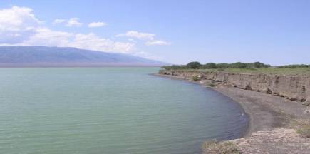
Picture 1.The Lake Alakol coastline
Coastline climate.The climate is
sharply continental,
it is cold and icy in winter. It is hot in summer; the water temperature is
+7-+15°С in late May,and reaches +20-+25°С in summer. The
weather is fine for 300 days a year and swimming season starts from mid-June
and continues till the end of September.
The healing qualities of the Lake Alakol. It is known that
the Great Silk Road passed by water “bowls” called “Alakol”. Even at that time
it was impossible for wayfarers after a hard and difficult travel not to
refresh themselves in the waters of the lake. They discovered that salty water
magically restores strength and enhance health. Skin attrition of the legs
disappeared,those who suffered with radiculitis forgot about the pain in
lumbarand even they stop to quarrel and argue. The modern medical researches
have already confirmed the healing qualities of the Lake.The sea breeze of the
Lake Alakol combined with dry and hot smell of steppe air, have favorableeffect
on the environment.
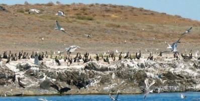
Picture2.Fauna of the Lake Alakol
Flora and fauna.The Lake is a real paradise
for birds. As archeologists note this unique place is marked on the map of
Kazakhstan as a “Silk Road” for birds. Birds usually stay here to have a rest
while flying from the North to the South. From 300 types of birds 38 are listed
in the Red book of the International Unity of Wildlife conservation such as
ancient seagull, European white pelican, Dalmatian pelican, egret, spoon-bill,
black stork, whooper swan etc. There are also Red-skin fishand Iliymarinka in
the waters of the Lake. In order to protect the ecosystem of the region, Alakol
State Reserve was established in 1998. Its area is 197 km2.
StateNational Nature Park “Burabay” is located in
Shuchinskiy district of Akmola region.The total area of the Park is 83,510 ha,
including 47,361 ha of forest area, 8,493 ha of ground water area. The climate
is a sharply continental. The average temperature is -16.70С in January and +18,60С in July.
There are 14 lakes
(small and large) such as UlkenShabakty,
KishiShabakty, Burabay, Shortan, Katarkol and Maybalyketc on the territory
of the Park. Also, there are some
rivers such as Kolshakty, Kylshakty, Sarybulak, Gromovaya, Imanay which flow
into the Lake.
Burabay Lake is situated at the territory
of Shuchinsky district. Its elevation
is 319 m above sea level. Zhumbaktas rock located in the Lake is a symbol of
Burabay Lake. The tallest mountain Kokshe of Burabay region is 997m above sea
level.
The nature ofBurabayattracts people with its beauty
and fresh air.The combination of high nountains, pine and birch forests,lakes creates special climate conditions
in the area.Fauna of the Natural Park Burabay represents 305 species including 87 rare
and endangered species. The flora comprises about 757 species. 12 species are
listed in the Red Book.Pines, birches, aspensand bushes comprise 65%, 31%, 3%
and 1% of wood vegetation in the Park respectively.
Interesting cliffs
and rocks such as Okzhetpes
(Inaccessible to Arrow), Sphinx, UykidagyBatyr (Sleeping Knight), Burkit
(Eagle) and Tuye (Camel) were formed as a result of wind and rain.There are
guesthouses, hotels, health resorts and children’s summer holiday camp in the
Park.
Tourists from all
over the world (Germany, France, Czech Republic, Turkey, Russian Federation
etc) visit this region for recovering health. Mud and mineral
springs of Burabay have healing
qualities.
There are sports complexes in Burabay
health resorts and excursions are held regularly. The fishing season starts in spring.
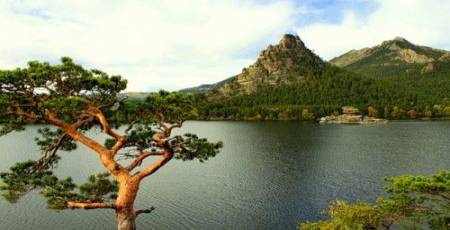
Picture 3. The Burabay Lake
The Kolsay Lakesare situated in the
eastern part of Kungey Alatau mountain ridge, 330 km away from Almaty and 10 km
away from the border of the Kyrgyz Republic. They are located at heights 1818,
2252 and 2850 metres above sea level. The Kolsay Lakes are suited for
hiking, horse riding, cycling.
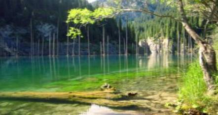
Picture 4. The KolsayLakes
The Kolsay Lakes are called “a pearl of North Tien-Shan”. The Lakes are
surrounded by forests, cliffs and mountains. The Kolsay Lakes comprises of
three lakes: theFirst Lake-the
altitude of the first lake is 1,818 m above sea level, its length is 1 km, the
width is 400 m and the depth is 80 m; the
Second Lake (middle Kolsay Lake), the largest and the most beautiful one
among three lakes, is located at 2,252 m above sea level, the depth is 50 m; the Third Lake(the highest Kolsay)is2,850
m above sea level. Also, the Kolsay Lakes are called “Blue field of North Tien-Shan”Dark blue color of water;
silence and calmness around are the specific features of the Kolsay Lakes.
In conclusion, the number of tourists visiting
Kazakhstan is increasing in recent years. There is a great potential for
development of tourism in Kazakhstan.The importance of Kazakhstan’s natural
beauty, flora and fauna, ecologically clean air and the lakes which are known
for healing qualities of water is increasing in the development of
tourism.
Bibliography:
1.
Traveler’s Reference Book-KZ - Almaty, 2007
2.
Reserves and National
Parks of Kazakhstan.
- Almaty: Kitap, 2006