K.M. Akpambetova
Karaganda State University named after E.A.Buketov, Kazakhstan
ECOLOGICAL
MONITORING OF ARID ZONES OF KAZAKHSTAN
Environmental problems capture practically
all natural zones of Kazakhstan, but especially brightly they were showed in
arid territories which concern the Western, Central and Southern Kazakhstan. In
the Western Kazakhstan ecological conditions are complicated by workings out of
oil fields and gas. The soil cover, underground waters, the organic world is
basically influenced. The increased
pollution of atmosphere which is saturated with harmful emissions of a
petroleum industry is observed. They drop out on a terrestrial
surface with precipitations, polluting all natural components. Depth of
infiltration of oil in soil reaches 1 m. Infiltration
of oil in soil leads to development of the processes, which destroy soil
structure and promoting formation of saline soils (solonchaks). Pollution of a
soil cover influences on the ability of self-restoration of vegetative
communities. The raising of level of Caspian sea endangers of flooding the oil
deposits at northern and northeast coasts. The 43 deposits get to a zone of
probable flooding, from which 32 - in Atyrau and 11 - in Mangistau areas with
the general geological resources of oil over 5 billion tons. The largest
deposits - Tengizsky, Royal, Kalamkas, Karazhanbas, and Northern Buzachi are
included. About 20 deposits, which are located in Atyrau area, are already have
undergone by sea influence. Among flooded – Armand
deposits, located on peninsula of Buzachi, Sea, Coastal, Deserted, Southwest,
Tazhigali, Terenozek and others. The 8 deposits in Mangistau area are captured
by flooding processes. There is a danger
of pollution of water area by oil products.
In the Central Kazakhstan deterioration of an ecological condition is
connected with field development. Here is located the largest
coal-field, which is called the Karaganda coal basin. Development and operation of a deposit
throughout several decades have led to degradation of an environment of
region. Antropogenic
forms of a relief are formed and such processes as salinization, waterlogging, impoundment have been strongly developed. The natural
processes are activated. Small particles of rock drifted by wind on huge distances and pollute
atmosphere and a soil-vegetative cover.
Superficial and underground waters are polluted. In deposits of
iron-manganous ore of Zhezkazgan region, sources of pollution are become
open-cast mines, dumps of the wasted rocks, stores of manganaous and iron ores,
coal and ashes dumps. In underground waters of a deposit from elements of 1
class of danger the increased content of beryl and phosphorus are marked; 2
classes - barium, arsenic, lithium and strontium; 3 classes - manganese and the
titan. The Balkhash mining industrial complex is the basic enterprise having
negative influence on an ecological condition of lake Balkhash. Toxic
substances such as copper, zinc, lead, cadmium, arsenic and antimony are got in
lake with firm emissions [1].
Ecological and geographical researches of the small rivers of river
basin Nura show, that the rivers are in a condition of degradation and full
disappearance. The river Nura has about 20 considerable inflows of first order.
The rivers Akbastau, Bajgozha, Kokpekty, Tuzdy, Shiderty, Ulken-Kunduzdy
attribute to constant rivers. The small rivers become polluted by utility and
industrial waters containing dissolved organic and
mineral substances.The poisonous substances arriving in water reservoirs, change
physical and chemical properties of water, a soil etc. Level of pollution of
rivers depends on peculiarity of applied technological processes. At the
expense of constantly arriving mine waters, the mineralization of the rivers
Big and Small Bukpa increases to 1,4 g/l in the spring, and to2,35 g/l in the autumn. These waters
have polluting influence on alluvial-prolluvial horizon of underground waters.
In annual balance of water feeding (feed) of the small rivers, underground
waters compose in average 30 %. These waters also arrive in the small rivers. As a result against various degree of a mineralization (from
0,4 to 13,4 %) pollution of underground
waters by nitrates (to 8 maximum permissible concentration), and their
increased oxidation is marked. High deposition of underground waters level in a
combination with their chemical compound and the increased content of
pollutants represent danger to aluminum and lead covers of a cable, and also
for some marks of cement and concrete. The organic substances containing in
samples of water, exceed maximum permissible concentration
in 16,5 times. Besides, individual excess of maximum permissible
concentration is increased in 10-15 times, arriving in waters from the diesel
stations submitting water for an irrigation.
Cosmodrome "Baikonur" also have a bad influence on
environment. Rocket fuel - geptil – relates to toxic connections of 1 class of hygienic danger, geptil is stable in soil and strongly
sorbs and agglomerates in objects of environment, representing potential threat
for health of the population of region. The mineral deposits and water
resources of underground waters are located directly in areas of falling of
separating parts of carrier rocket and in zones of their influence. When making ecologic
and geomorphologic mapping, first of all it is necessary to pay attention to
microform of relief. In territory of research, distribution and accumulation of
rocket fuel will be in direct dependence on degree of a dividing of a relief.
Concentrations of geptil are concentrated in places of gutterof thawed, soil
and underground waters, in deepening of relief. The high content of geptil in
plants that is connected with good solubility in water and comprehensibility of
plants is noticed. Stability of geptil depends on type and structure of soil.
If the sandy soil sorbs to 40 % of geptil, the clay soil is capable sorb to 90
% of geptil. The 40 % of geptil, depending on type of soils, can remain in
soils till 1 year and more. The modern antropogenic changes on arid geosystems
of the Central Kazakhstan create an intense ecological situation in region,
where the critical conditions of landscapes, leading to infringement of their
stability and structure.
The extensive spaces stretching to the
north from Kopet-Dag, Altai and Tan-Shan, having a complex and various relief,
represent Southern Kazakhstan. Prevalence of sandy-argillaceous breeds on
surfaces, high temperatures of soil, reducing of vegetative cover are created
conditions for development of atmogenic processes.
Low mountain ridges press in limits of a low strip, dividing it on the
isolated sandy sites. The strip of deserts is formed by sandy massifs (mountain
ranges) of East Priaralja, Kyzylkum, Mojynkum and sands of
Southern Pribalhashja. From modern processes
which influence relief formation, deflation and antropogenic processes are
widespread.The basic ecological problem not only of Southern Kazakhstan, but a
whole republic, is connected with the greatest catastrophe of 20 centuries -
drying of Aral sea. This problem concerns to the category of global
environmental problems. Now the dried up bottom of Aral sea represents lifeless
sandy desert, with the area more than 27 thousand км2. Annually, 75 million tons of sand and a dust
from a surface of this desert rise in atmosphere of the earth. Besides, fine
dust and salt from a surface of saline soils (solonchaks) are taken out in
atmosphere, which are not besieged mechanically and are not registered by usual
devices. The quantity of such poisonous salt can reach about 65 million ton in year.
They are raised by wind on height of several kilometers, forming
sole-dust clouds, and are transferred on enormous distances [3].
Process of drying of Aral sea has affected all natural components of region.
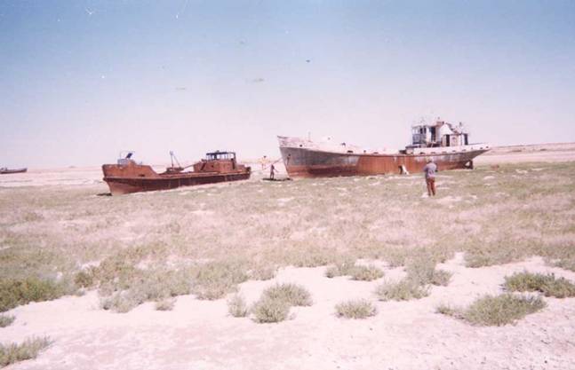
Fig. 1 Aral
today [4].
Ecological problems of Ilie-Balkhash region are
connected with processes of salinization, waterlogging, impoundment.
Activization of the given processes is caused by antropogeniс
activity. There are irrigated
massifs and pastures. Waterlogging processes in a valley of the river Ilie became more
active as a result of building of the Kapchagaj water basin and a water utilization
for irrigation. Large sites of waterlogging located
on costal strip of lake Balkhash. There are characteristic natural-territorial
complexes of landscapes in Akdalinsky and Karatalsky irrigated sites: filtrational lakes are formed in deepening of
relief, on reserves of irrigation canals and channels of the old rivers, owing
to flood of waste waters from irrigated fields, saline soils (solonchaks) were
formed.
Thus,
ecological problems of arid zones of Kazakhstan have not only republican, but
also the international level. It is necessary to solve problem by joint efforts
of the countries of PriCaspian and Priaralsky regions.
References
1.
Akpambetova K.M. The ecological consequences
of workings out of mineral deposits on environment. - Actual problems of human
health and formation of an inhabitancy/ Sources of the international
scientifically-practical conference/. Karaganda, 2002, pages 23-27
2.
Akpambetova K.M. Ecologic-geomorphologic
characteristic of the small rivers of basin Nura. - Modern problems of
geoecology and sozology/ Reports to the international scientifically-practical
conference/. Almaty, 2001г., pages. 283-285
3.
Tursunov A.A. Avert a trouble. - Aral: today
and tomorrow. Alma-Ata, Kajnar, 1990 pages. 98-113
4.
Photographic materials of
Tourist-geographical expedition «Karaganda - Aral - Caspian sea» - 1999. The Karaganda regional tourist club. - Karaganda, 1999.