Antoni Tadeusz Miler, Andrzej Czerniak, Sylwester
Grajewski, Bogusław Kamiński,
Department of Forest Engineering
The August Cieszkowski Agricultural
Marshlands of the
Summary
The aim of
the present work is a description of a multi-year complex field research (hydrological, chemical and
geotechnical) carried out on the area of the Forest Promotion Complex ”Lasy
Rychtalskie”. The work focused on characterizing the present state, forecasting
future changes, as well as indicating the stability threats which the areas
face. The marshlands in focus are characteristic for their high storage
capabilities. Water relation changes forecast for the investigated areas,
expressed by groundwater level changes, was based on the negative annual atmospheric precipitation trend. It was assumed
that significant changes in marshland ecosystems would occur in the situation
of at least 50 % decrease of the present mean groundwater level. It will take
about 100 years. The carried out chemical tests did not reveal any excessive
cumulation of chemical pollutants either in soil or both ground and surface
waters of the Complex. Dirt roads based on marshy subsoil did not meet, in the
period of the whole year, the bearing strength requirements defined for forest
roads.
Key words: forest
marshlands, water condition, water and soil quality, road bearing strength
INTRODUCTION
The Forest Promotion Complex ”Lasy Rychtalskie” (with its area of
approx. 48 thou. ha) comprises
the forests of both two inspectorates of the Regional Directorate of State
Forets in Poznań; namely Syców and Antonin, and those of the
Experimental Forest Complex in Siemianice. The area is located on the grounds
belonging to the III Wielkopolsko-Pomorska Region, the 9 Province of the
Zmigrodzko-Grabowska Valley, as well as the V Silesian Region of the 2
Breslau Province. The marshy habitats in focus cover the following areas of the
total acreage expressed in percentage: Antonin 1.2 %, i.e. 239 ha, Syców
1.0 %, i.e. 221 ha, and Siemianice 6.3 %, i.e. 375 ha (Miler et al. 2005).
Some worldwide recognised scientific centers suggest that the process of intensive cumulation of chemical
pollutants, taking place both in organic soils and waters of marshy areas, may
have been going on for a long period of time; the supposition corresponds to
trace elements and dioxins generated by industrial centers.
The existing road
network is a significant element of the marshy lands technical infrastructure.
Both its density and technical state of forest roads provide, to a high degree,
conditions for proper management of forests. Mineral marshy areas, particularly organic ones, are
characterized by low bearing capacity, which is further lowered at the time of
high groundwater levels.
The aim of
the work is to describe and present the results of the multi-year complex field
investigations (hydrological, chemical and geotechnical) carried out in the
marshy areas of the Rychtal Forests Complex. The final aim is to define the
present state, to forecast the changes, as well as indicating the possible
danger to the stability of the areas.
MATERIALS AND METHODS
Description of the experimental plots and
general range of investigations
Three experimental plots were selected for the detailed investigations.
They were microcatchments (8.58; 30.61 and 32.00 ha), which are almost entirely
situated on forest marshlands. This is the most significant element in the
proposed experiment since the core of it is an evaluation of the outflow from
the defined area with excessive moisture.
The field research
was begun in 2004. It comprised among others, limnigraphic water levels
measurements in watercourses at Thomson overflows, weekly ground water levels
measurements, collecting samples of surface and ground water, as well as soil
for chemical determination (twice a year) and testing the bearing capacity of
road; it was carried out applying the VSS apparatus (periodically). The
meteorological data were obtained from the Siemianice station.
An assumption of
the water relation changes for the area was worked out utilizing the temporal
trends of mean annual air temperatures, as well sums of annual atmospheric
precipitation. The conceptual Nash model (Miler 1994) was employed to model the
storm flow outflows from the marshy areas. It was attempted to measure the effective
precipitation applying SCS-CN method. An evaluation of the Forest Complex areas
was attempted focusing on the potential capabilities of the area to retain
water. The pilot type activities were carried out for the
Model SCS-CN
Model SCS-CN is a conceptual model of division
of the total precipitation in its original form worked out in the 50’s of XXc.
by the Natural Resources Conservation Service in the
The basic assumptions of the model state the
equality of the proportions of factual storage (F) to maximum catchment storage (S), as well as effective precipitation to the total precipitation
decreased by the initial loss (1), balance assumption stating that the total
precipitation (P) is the sum of the
initial loss (Ia), factual
infiltration (F) and effective
precipitation (Pe) (2). Parameter CN
is bounded by empirical dependence with (S)
parameter. Additionally the value of the initial loss (Ia) was bound to the potential storage maximum value (S) (3) (Mishra, Singh 2003) basing on the principle of equality of empirical dependence.
Thus:
![]() (1)
(1)
![]() (2)
(2)
![]() (3)
(3)
It was
empirically proved that
λÎ[0; 0.3], in the original model it
was accepted that λ is 0.2 (USDA-NRCS 1985).
Simple
transformations deliver the following:
 for P>Ia (4)
![]() for P£Ia (5)
for P£Ia (5)
Maximum storage S is bound
with the non-dimensional CN Î [1; 100], for P, Pe, S values expressed in millimeters, S
is calculated from the dependence:
 (6)
(6)
The method SCS-CN was initially constructed for
agricultural areas.
 (7)
(7)
where: CNemp – empirical value of CN
parameter, CN – parameter value according to the original method, a, b
– empirical coefficients.
Making use of pairs of corresponding
parameter CN values i.e. the values calculated basing on the original
method (CN), as well as calculated for a given catchment on the basis of
empirical data (CNemp),
coefficients a and b are calculated for the equation (7) from a regression dependence.
Basing on the parameterized equation
the values of CN are recalculated
according to the original method taking into consideration the given catchment
outflow conditions in relation to the varied features of forest cover.
Potential storage capabilities
Both climatic and
non-climatic physico-chemical elements modify the local capabilities of water
storage. The elements such as: relief, soils and geological structure,
watercourses network, stagnant waters and plant cover (species and age
structure etc.) condition potential water storage capabilities. Evaluating of a
potential storage capability consists in ascribing to each elementary
homogenous area a parameter which considers a total impact of most significant
physico-geographical parameters (Miler et al. 2001). Subsection is accepted here as an elementary surface. It
facilitates almost direct utilization of the data stored in the bases
constructed during forest management activities (Grajewski 2006). Each of the
subsection was ascribed certain parameters which were regarded as crucial in
determining its potential storage capability. The following parameters were
regarded as determinants: mean ground slope [%], habitat moisture type [-],
distance from watercourses network [m], distance from stagnant waters [m], mean
weighted soil filtration coefficient [mm∙s-1], stand
compaction index [-], type of soil cover [-], stand age [years], type of forest
habitat [-], and stand dominating
species [-]. Next the ranges of changes of each parameter values were divided
into three classes corresponding to: ”low”,
”medium” and ”high” storage capability, coding them as: 1, 2 and 3. ”Low” (code 1) potential storage capability
of a given subsection was associated with the dry type of habitat’s moisture, short distances from the watercourses
network, high soil filtration coefficients, low index of forest compaction, exposed
soil cover, young stands, dry oak habitats, as well as deciduous species. Whereas,
”high” potential storage capacity of
a given sub
series
was associated with marshy type of habitat moisture, long distances from the
watercourses network, low values of soil filtration coefficient, high ratio of
stand compaction, moss soil cover, mature stands, marshy and riparian habitats,
as well as coniferous species. What followed was summing up of codes of all the
parameters separately for each of the sub series. And thus a certain numerical
value was obtained for each of the sub series, which was an indicator of
potential storage capabilities from the range
(min = 10 ÷ max = 30). It results from a simple
valuation: min = 10(characteristics)
· 1(min codes) = 10, and max =
10(characteristics) · 3 (max codes) = 30. Spatial distribution of
the indicator, in the form of a map, enables indicating the areas of ”low”,
”medium” and ”high” potential storage capabilities of the analysed area.
Chemical investigations
Within the framework of the chemical investigations
the following steps were taken:
1.
Determination
of major soil, ground and surface water pollutants indexes,
2.
Estimation of heavy metals
cumulation on the basis of soil magnetic susceptibility distribution in both
horizontal and vertical system,
3.
Determination of dioxins
content in soil.
Ad. 1. Methods of determination of major indexes of
soil, ground and surface water chemical pollutants – Polish Norms.
Ad. 2. Magnetic susceptibility is an easily
measurable geophysical value describing an ability of a given substance to
magnetizing changes under an influence of the exterior magnetic field.
The procedure
of measurements of magnetic susceptibility is based on an evident relation
between an increase of magnetic susceptibility, and the content of heavy metals
in soil. Strzyszcz (2003) comments that soil surface magnetic susceptibility
reaching from 30´10-5 to 50´10-5 may indicate that the amount of at
least one metal exceeds the boundary value permitted for forest soils. Magnometry is a method alternative to expensive geochemical
methods. The method is specially useful in forest areas where a long-period
deposition of pollutants (including magnetic particles) is not disturbed by
agro-technical practices.
Soil magnetic
susceptibility was analysed applying the determination of surface and
vertical distribution of ferromagnets.
The
surface measurements were carried out applying a magnetic susceptibility meter
equipped with an English field sensor MS2D produced by Bartington Instruments
Company, integrated with GPS Pathfinder American system manufactured by Trimble
firm.
Vertical distribution of magnetic
susceptibility was analysed using Czech produced SM 400 magnetic susceptibility
meter, type - ZH Instruments –
Ad. 3. Dioxins come into
existence as an undesirable side-effect of some industrial or combustion
processes, or as a result of various damages. The basic source of emissions
into the environment are: industrial refuse, herbicides, pesticides, and
transformer oils.
Dioxins are also produced as a
result of an uncontrolled coal combustion which takes place in stoves, boiler
rooms and refuse heaps containing chlorine bounded in both organic and
inorganic form. Fires can also be a source of the elements. Dioxin content
identification in soil was carried out by help of gas chromatography technique
in combination with mass spectometry with a double fragmentation of the investigated
molecule applying type MAT GCQ and GC-MS/MS (Grochowalski 2000)
appliances.
The level of toxicity of the
analysed samples expressed as standardized value TEQ, was calculated applying
the so-called equivalent toxicity coefficient TEF on the basis of the chemical
analyses of mass content of congeners PCDDs and PCDFs having chlorine atoms in
positions 2, 3, 7 and 8.
Forest roads bearing strength
The aim of the
research was determining the influence of the water table level in soil sub grade on bearing
strength of forest roads pavements.
Bearing strength
investiagtions were carried out of roads with soil and non-rehabilitated paved
surfaces built from debris, slag and melafire break stone. Constructions of
non-rehabilitated paved surfaces were founded on a filtering off course having
0.2 m thickness.
All the experimental road
sections were founded on soil-marsh subsoil, and bearing strength
investigations were carried out in the conditions of extreme groundwater table
level in the subsoil. VSS apparatus with a pressure slab of 0.30 m in parameter
was applied to determine bearing strength. Reformation index Io was also calculated.
RESULTS AND DISCUSSION
Water relations
Annual outflow from
the areas in focus is relatively low approx. 4 % of the annual sum. The watercourses
disappear seasonally – in hydrological years 2004/2005 and 2005/2006 there was
an observed outflow during the periods of respectively 202 days
((15.11.2004–5.6.2005) and 192 days (1.12.2005–10.6.2006). In the period of the
investigations no typical, i.e. basing on surface runoff, storm flows were
observed. Normally they last in the investigated catchments for no longer than
a few hours during heavy rainfalls. The observed storm flows – increased
outflows of rain-thaw or rain type-were fed by both subsurface and ground
outflows. The above proves a relatively high storage capability of the marshlands
in focus. (stands, forest bed, ground depressions, soils).
Average groundwater
levels (51 wells) are placed shallow i.e. 97.5 cm below ground level, with
standard deviation 55.5 cm. Outflows occur in watercourses when groundwater
levels are higher than their approximated mean annual values.
Nash model – a
conceptual catchment model – was used to model the observed precipitation-storm
flows incidents: N-identical, linear reservoirs with time-constant T
(Miler 1994). A proper evaluation of effective precipitation is crucial in case
of precipitation-outflow models. Effective precipitation can be calculated on
the basis of coefficients of storm flow outflows i.e. quotients of storm flow
outflows and sums of precipitations causing the storm flows. Then the results
of Nash model simulation are fairly good for the investigated catchments. An exemplary result of
simulation for ditch G-8 catchment is presented in Fig. 1.
The following
trends were calculated basing on the data from Siemianice (1957-2006): mean
annual air temperatures (+0.041 oC/year) and annual atmospheric
precipitation sums (-1.573 mm/year). The above
trends are significant statistically respectively at the significance level a=0.05 and 0.25.
Positive air temperature trend will undoubtedly stimulate evapotranspiration
growth which depends on many factors, among others access to water. It can be
thus assumed in the forecast that evapotranspiration will not undergo
significant changes. The outflow from the investigated areas is insignificant
so it can be not taken into consideration in the prediction.
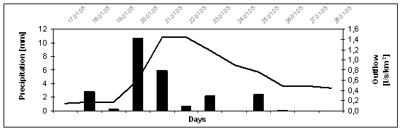
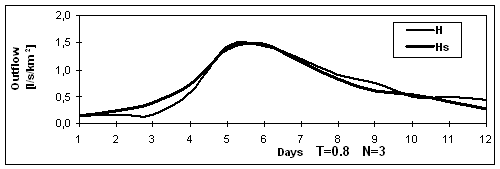
Fig. 1. Example result of storm flow modelling in
marshlands on the Promotion Forest Complex “Lasy Rychtalskie” (H – measured
outflow, Hs – simulated outflow)
Finally the
prediction of water relation changes in the area in focus, expressed by
groundwater level changes, can be founded on negative atmospheric precipitation
trend. If it is assumed that significant changes in marshy ecosystems will
occur alongside with a decrease of average groundwater level by approx. 50 cm
(50 % of the present average groundwater level), as a result of decreasing annual atmospheric
precipitation sums, it can be calculated that this will happen in about 100
years.
Modelling of effective
precipitation
Modelling of effective precipitation
accompanied by the modified SCS-CN model was carried out on the basis of the
empirical data gathered in 2005 hydrological year from the forest marshland
catchment (ditch G-8) having the area of 32 ha. Storm flows episodes, as well
as precipitation sums, connected with them were taken into consideration in the
period of the year. Modelling assumptions were met by three storm flow incidents,
which were qualified for the modelling procedure i.e. the episodes from the
periods 17.01–28-01.2005, 06.04–21.04.2005, 01.05–14.05.2005.
The procedure of calculating
parameter CN empirical values was carried out, taking into consideration
initial moisture values for precipitation episodes, in agreement with factual
soil moisture (soil before precipitation bringing about storm flow – AMC).
Results of subsequent precipitation episodes are gathered in Tab.1.
Tab.
1.
Results of modelling for ditch G-8 catchment
|
Rainfall episode period |
Period |
Actual antecedent moisture of soil before rainfall (AMC) |
Average empirical value of CN
parameter for the catchment |
Maximum storage |
Total rainfall |
Direct runoff |
Empirical runoff coefficient |
Direct runoff according to the model |
Runoff coefficient according to model |
|
|
t |
AMC |
CN |
S |
P |
Pe |
Α |
Pe |
Α |
|
|
[days] |
[-] |
[-] |
[mm] |
[mm] |
[mm] |
[-] |
[mm] |
[-] |
|
17.01-28-01. 2005 |
8 |
III |
76.4 |
78 |
25.1 |
0.56 |
0.022 |
1.12 |
0.0446 |
|
06.04-21.04. 2005 |
3 |
II |
33.9 |
495 |
24.3 |
2.75 |
0.113 |
Condition of the model P>0.2×S |
|
|
01.05-14.05. 2005 |
9 |
I |
20.4 |
991 |
42.4 |
1.69 |
0.04 |
||
Results of effective
precipitation modelling with help of SCS-CN model in the version adjusted to the conditions of
the catchment cover can be viewed only in estimating categories.
The features of ditch G-8
catchment (marshland) are unfavourable for creating surface and subsurface outflow. And thus SCS-CN model has
noticeably limited applications for marshlands.
Potential storage
capabilities in the Marianka Experimental Forest Range
The map depicting
spatial variability of potential storage capability index of the
Chemical investigations
As a result of the
carried out chemical tests of both soils and waters of the marshlands in the
Mariak and Marianka Forest Ranges no strong cumulation processes of
anthropogenic origin pollutants were found. The obtained research results were compared with corresponding standards
of soil quality (Polish Standard), and boundary values of surface and
underground water quality indexes, the manner of monitoring procedures, as well
as ways of interpreting the results and presenting the levels of the waters
(Polish Standard).
Water-soil environment
of the analysed marshlands poses
no danger to the neighbouring forest complexes from the chemical point of view (Miler et al.
2006).
As far as grounds
are concerned, the content of heavy metals, apart from cadmium, was found to be
within the value range accepted for areas protected by legal regulations
concerning the cleanest natural reserves belonging to group A. The content of cadmium at some research plots
insignificantly exceeded the permissible values defined for cadmium, but did
not exceed the values for group B areas i.e. arable, forest and afforestation
areas. The investigated soils were characterized by a high variability of iron
concentration.
An increased cumulation of heavy metals (apart from
iron) was not confirmed by the initially conducted magnometric investigations.
It is assumed that non-polluted soils are characterized by a natural magnetic
susceptibility (below 30´10-5). Magnetic susceptibility within the range from 30´10-5
to 50´10-5 indicates
an increased content of anthropogenic ferromagnets. Magnetic susceptibility
from 50´10-5 to
100´10-5 is regarded as high, and
above100´10-5 as
very high. The average Polish magnetic susceptibility for forest soils is
defined on the basis of the Map of Magnetic Susceptibility of Soils of Poland
and equals to 22´10-5.
Investigations of the surface magnetic susceptibility of marshy areas
soils showed an increased concentration of iron, while the share of other
ferromagnets proved to be low. Κ values were
contained within the range from 15´10-5 to
70´10-5. The distribution of ferromagnets was
correlated with the type of the investigated soils.
The investigations
of the vertical magnetic susceptibility distribution proved that the maximum κ values generally did not
exceed the value of 50´10-5. The maximum
of κ value was found at the depth
of 4.0 to 10.0 cm in all of the investigated research plots.
As a result of the
carried out chemical analyses the total value of congeners PCDDs and PCDFs in
the investigated soil samples did not exceed the value of 8.0 ng PCDD/F- TEQ/kg. To compare the
content of PCDDs and PCDFs in agriculturally utilized soils must not exceed 10
ng/kg, and for non-arable soils the value is 50 ng/kg.
Road bearing strength investigations
Synthetic results
of forest road bearing strength investigations carried out on the area of the
Lasy Rychtalskie Complex marshlands are gathered in Tab.2. From among four investigated forest road on bog - basis best showed
pavement with broken trick / concrete broken stone.
Tab. 2. Reformation modules of forest roads pavements
for extremely deep groundwater levels in road subsoil
|
Location and type of pavement |
Primary E1
and secondary E2 pressure
value |
Reformation modules in MPa and Io = E2/E1 |
Terms of tests and groundwater level b.g.s. |
||
|
Range of primary pressures in MPa |
|||||
|
0.05
– 0.15 |
0.15
– 0.25 |
0.25
– 0.35 |
|||
|
Marianka – broken trick/ concrete broken stone |
E1 |
91.8 |
78.9 |
104.6 |
August 2005 183 cm |
|
E2 |
83.3 |
107.1 |
125.0 |
||
|
Io |
0.91 |
1.36 |
1.19 |
||
|
E1 |
30.8 |
34.9 |
40.9 |
April 2006 73 cm |
|
|
E2 |
51.7 |
62.5 |
72.6 |
||
|
Io |
1.68 |
1.79 |
1.77 |
||
|
Marianka
– dirt road |
E1 |
12.3 |
8.9 |
4.0 |
August 2005 182 cm |
|
E2 |
17.2 |
18.0 |
6.7 |
||
|
Io |
1.40 |
2.03 |
1.66 |
||
|
E1 |
5.9 |
6.7 |
2.1 |
April 2006 61 cm |
|
|
E2 |
4.2 |
- |
- |
||
|
Io |
0.71 |
- |
- |
||
|
Mariak
– melafire broken
stone |
E1 |
46.4 |
43.7 |
31.5 |
August 2005 38 cm |
|
E2 |
48.9 |
70.3 |
80.4 |
||
|
Io |
1.05 |
1.61 |
2.55 |
||
|
E1 |
24.9 |
30.6 |
36.0 |
April 2006 33 cm |
|
|
E2 |
54.2 |
69.2 |
73.8 |
||
|
Io |
2.18 |
2.26 |
2.05 |
||
|
Mariak
– slag |
E1 |
84.9 |
67.2 |
54.9 |
August 2005 45 cm |
|
E2 |
84.9 |
100.0 |
166.7 |
||
|
Io |
1.00 |
1.49 |
3.04 |
||
|
E1 |
48.9 |
54.2 |
43.7 |
April 2006 33 cm |
|
|
E2 |
69.2 |
70.3 |
67.2 |
||
|
Io |
1.41 |
1.30 |
1.54 |
||
The surface met the
criteria of bearing strength for forests roads with traffic load of KR – 1 E1 > 100 MPa. It must be
noticed though that the bearing strength (E1
= 104.6 Mpa) was reached in dry conditions, when groundwater level decreased to
below 180 cm. The same surface lost up to 60 % of its bearing strength in the
situation of groundwater table increase by 110 cm.
In the Mariak
forest range the roads with slag pavement were situated in the areas where ground
waters were shallow i.e. 33 to 45 cm below ground level.
Both pavements reached the strength meeting the
bordering requirements set for road foundation and improved subsoil. Increased
bearing strength can be achieved by lowering the groundwater level within the
road frame. The changes will influence a decrease of water level in the neighbouring forest
stand, which will have an impact on decreasing the area of protected marshes.
And thus the solutions for an improvement of marshlands roads bearing strength
should be searched for in the areas of various types of pavement construction
and road subsoil reinforcements. Geosynthetics provide for obtaining good
results in the construction of pavements (Kamiński, Czerniak 2003,
Czerniak, Kamiński 2003).
SUMMING UP AND CONCLUSIONS
The annual outflow
from the investigated marshlands is relatively low at 4 % of the annual
precipitation sum. Watercourses periodically take water away, mainly in the
winter half-year. No typical storm flows were observed; only increased
precipitation-thaw or subsurface or ground- fed rain outflows were recorded.
Modelling the outflows from the areas, especially storm flow type one is
significantly restricted by difficulties to evaluate the effective
precipitation.
Water deficit which will occur in a relatively close future is the main
threat to the ecosystems of the Lasy Rychtalskie Complex. It will take about
100 years – degradation of marshlands.
The carried out chemical investigations did not
show an excessive cumulation of chemical pollutants in soils, as well as
surface and ground waters of the Complex.
Dirt roads situated
on marshy subsoil did not meet the conditions of bearing strength ascribed to
forest roads. The strength of hard not improved roads depended mostly on the
groundwater table level in the subsoil.
REFERENCES
Czerniak A.,
Kamiński B. Przydatność
geokraty do budowy dróg leśnych. PTPN,
Wydz. Nauk Roln. i Leś., Prace Kom. Nauk Roln. i Leś. T. 94. 41 – 48,
2003.
Grajewski S. Stosunki wodne oraz zdolność
retencyjna obszarów leśnych Parku Krajobrazowego Puszcza Zielonka. Wyd. AR w Pozn. Ser. Rozpr. Nauk. nr 382, 2006.
Grochowalski A. Badania nad oznaczaniem polichlorowanych
dibenzodioksyn, dibenzofuranów i bifenyli. Zesz. Nauk. Politech.
Krakow., Monograf. 272, Kraków, 2000.
Kamiński B.,
Czerniak A. Zastosowanie geokraty
komórkowej do wzmocnienia gruntowej drogi leśnej na podłożu
spoistym. Wyd. AR w Pozn. 478 – 486, 2003.
Miler A. Modelowanie
matematyczne zdolności retencyjnych małych zlewni nizinnych. Rocz.
AR, Rozpr. Nauk. z.258, Pozn. 1994.
Miler A.T., Grajewski
S., Okoński B. Stosunki wodne w
wybranych ekosystemach Puszczy Zielonka. Monograf. Wyd. AR Pozn. 2001.
Miler A.T., Kamiński B., Krysztofiak A., Sobalak M.
Inwentaryzacja obszarów mokradłowych na terenie Leśnego
Kompleksu Promocyjnego Lasy Rychtalskie oraz wstępne wyniki badań
hydrologicznych. Infrastruktura i Ekologia Obszarów Wiejskich, PAN Kom.
Techn. Infrastruktury Wsi 4, 2005, 85-98.
Miler A.T., Kamiński B., Czerniak A., Grajewski
S., Okoński B., Stasik R., Krysztofiak A., Sobalak M., Poszyler-Adamska
A., Przysiecka K., Kamiński M. Opracowanie strategii ochrony
obszarów mokradłowych na terenie leśnych kompleksów
promocyjnych na przykładzie LKP Lasy Rychtalskie. Nr zad. 18. DGLP (typescript), 2006.
Mishra
S.K., Singh V.P. Soil
Conservation Service Curve Number (SCS-CN) Methodology, Kluwer Academic Publishers,
Okoński B. Modelowanie odpływu bezpośredniego w zależności od
stanów pokrycia zlewni leśnej. Ser.
Rozpr. Nauk. Zesz., 374, Wyd. AR, Pozn.
2006.
Strzyszcz Z., Magiera T. Ocena zanieczyszczenia gleb leśnych na podstawie podatności
magnetycznej na przykładzie nadleśnictwa Katowice. Prace IBL, W-wa,
A: 961, 19-30, 2003.
Trampler T., Kliczkowska A., Dmyterko E., Sierpińska
A. Regionalizacja przyrodniczo-leśna na podstawach
ekologiczno-fizjograficznych. Wyd. UAM Pozn. 1990.
USDA-NRCS National
Engineering Handbook
Hydrology, Section 4, US Dept. of Agriculture, National Resources Conservation
Service, Washington D.C., 1985.