Cand.Tech.Sci. Ponomareva M.V., Blochitsyna
A., Nikitina A., Ponomareva Ye.
Karaganda
State Technical University. Kazakhstan
Optimization of geophysical
research
in Kotyrtas deposit’s wells
Kotyrtas
deposit is situated in the south-east part of Caspian Depression in the
Republic of Kazakhstan. Base wells are exposed by the complex of geophysical
methods. Main criterias for selection of base wells are maximum completion of
producing reservoir, production
test, characteristic of cut by core and uniform well spacing. Researches were
conducted both open hole and cased-hole by oilfield service companies.
Primary objectives of geophysical well logging on Kotyrtas
deposit were geologic-geophysical vertical exploration of well, selection
and correlation of geophysical log markers, lithological
layering, reservoir limit test, stratification and
areal convergence of reserves, allocation of collector layers, estimation of
reservoir saturation type, quantitative determination of net thickness
collector layers` reservoir properties, well integrity study.
According
on results of prospecting, development and exploitation drilling it is
found that a productive stratum is dated to Middle Trias. The productive
formations were penetrated by using drilling mud which is created by thoroughly
mixing water with clay to a desired consistency.
Drilling
mud electrical resistivity was measured by a borehole resistivity meter in the
process of micrologging and lateral logging curves matching plotted against thick
layer of clay with bilayered master curve. Nonfilterable drilling mud was used during the
drilling of several wells. It limited
using other modifications of resistivity method except induction logging.
Recording
of geophysical well logging curves was performed by
logging laboratories with digital recorder.
Logging
in prospecting and development wells was conducted in 2-3 cycles according to
completion of formation. Logging in exploitation wells was conducted in 1 cycle
after completion of objective horizon`s formation. Geophysical researches in wells
included general exploration on well bore in 1:500 scale and detailed
exploration of producing intervals in 1:200 scale.
Basic logging suite in prospecting and development wells (1:200, 1:500
scale) included followed methods: standard logging by inverted (B0.5A2M, N0.25M2.25A) and standard (M2A0.5B)
devices with one-time SP, caliper, acoustic logging, inclinometry,
geological-technical study, seven-electrode lateral
log with different transmission distance aiming to identification of
resistivity radial gradient and laterlog diagrams quality control. Curves
recording in several wells was conducted by 4L and 8L lateral logging.
Radiation
logging included gamma ray and neutron-gamma ray curves all over the vertical exploration in wells.
Lateral
logging, micro loging, caliper logging and radiation logging were
perfomed in 1:200 scale from surface casing to bottom hole in the beginning of
prospecting drilling.
In exploitation
wells general researches in 1:500 scale include: standard logging by inverted
and standard devices with one-time SP, caliper and radiation logging.
Detailed
exploration of producing intervals in 1:200 scale includes previously mentioned
methods and lateral logging sounding,
lateral logging, induction logging and micro logging sounding.
Inclinometry,
cement top location and cementing control were conducted to explore technical
conditions of wells
Inclinometry
was used for hole accuracy control. Cementing quality control and cement top
location were defined with using acoustic cement bond log and thermometry.
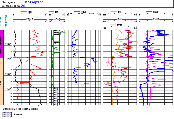

Picture 1 - Geological parameters of supporting layers
The
estimation of geophysical data quality
was realized in all the working wells. Correction of using curves was made in
case of need. Totally, completeness and quality of achieved logging data allow
to allocate reservoirs and to estimate its filtration-volumetric
characteristics and oil saturation.
Provided
that quality of measurement is fine researches conducted in wells allow to
solve primary objectives. Controlling-interpretation groups of production
department regulated calibration and curves repeatability in sealing intervals.
Final
quality control of geophysical data was carried out in process of complex
interpretation by static analysis of
geophysical data in supporting layer of workable well. Layers of salt and anhydrite are counted as
supporting layers. Geological parameters are given at picture 1.