Estimation of the local
riverine pollution load
to the lagoon on the Southern
Robert Bogdanowicz, Roman Cieslinski,
Jan Drwal, Artur Cysewski
Department of Hydrology,
Keywords:
1.
Introduction
The lagoons on the southern Baltic coast belong to the
most eutrophic marine ecosystems in northern
2. Method
and materials
Most of the studies dealing with the problem of water
pollution and eutrophication of the Puck Lagoon were
based on the data from the state monitoring system. The only water quality
sampling point in the drainage area of the Lagoon is located in Wejherowo, in the
Nutrients concentrations in four main streams entering
the Puck Lagoon have been measured at water quality sampling points situated
closest to the rivers outlets. The location of control points allowed for
estimation of pollution load from the whole drainage area, which was not
possible in standard monitoring. The research was concentrated on total
nitrogen and total phosphorus analysis, but other forms of nitrogen (ammonium,
nitrates, nitrite and organic nitrogen) and phosphorus (orthophosphates) were
also taken into account. The research was oriented on pollution load estimation, therefore water quality sampling and river flow
measurements were carried out simultaneously. In order to compare the results
of the research with the estimates based on regular, state monitoring, the data
from the
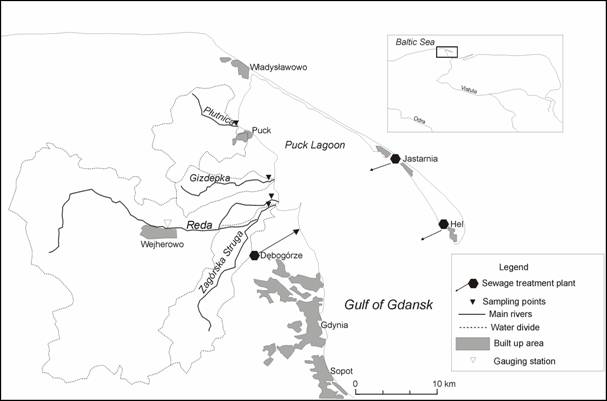
Fig. 1. Study area
3.
Characteristics of the study area
3.1
The Puck Lagoon
The Puck Lagoon is separated from the rest of the
The hydrographic
conditions of the Puck Lagoon are very favourable to the development of life.
The biodiversity of the Lagoon counts among the greatest of all the waters in
the Polish coastal zone. The analysis of
water quality in the Lagoon has indicated high levels of phosphorus, especially
in the forefront of the largest rivers outlets, namely Reda
and Plutnica. High nutrients content has been also
reported in the bottom deposits (Kruk-Dowgiallo,
2004). The Puck Lagoon is a unique biotope for
macrophytes. In the sixties of the last century,
60 % of the biomass in the bottom vegetation consisted of brown algae and the eelgrass Zostera marina. However, increasing discharges from land resulted in a
continuous deterioration of the bottom vegetation, and in the end of the 1970s,
the former dominating species started to be replaced by filamentous brown algae
(Lundberg, 2005).
3.2
The drainage basin
Over 150,000 people live in the region, mostly along
the coast. The area is very close to
The largest river entering the Lagoon is the
Tab. 1. Selected characteristics of the main rivers in the Puck
Lagoon drainage basin
|
River |
Catchment area [km2] |
Distance of the sampling
point from the river outlet [m] |
Mean specific runoff in
2006 [dm3×s-1×km-2] |
|
Zagorska Struga |
105,2 |
1050 |
9 |
|
Reda |
485,5 |
1000 |
9 |
|
Gizdepka |
37,2 |
770 |
4 |
|
Plutnica |
84,0 |
350 |
8 |
Water conditions in the Puck Lagoon
drainage basin are influenced by relatively high annual rainfall in the western
and the southern part of the basin (>700mm), and low rainfall on the coast
(<
The Reda and the Zagorska Struga river basins are
in 40% forested, with the domination of mixed (coniferous and deciduous) forest
complexes. The Gizdepka basin contains large
proportion of farming areas. Over 15% of land comprised of meadows and pastures
is typical for the Zagorska Struga
and the
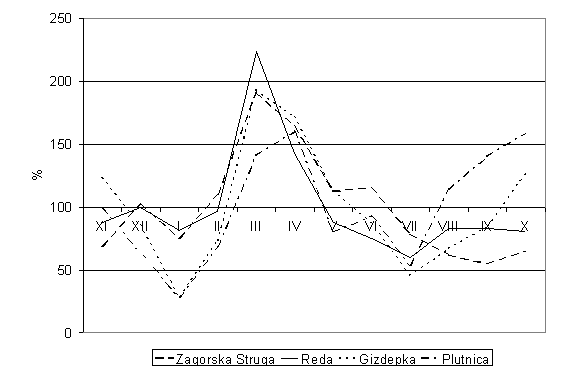
Fig. 2. Seasonal changes of monthly flow in relation to average annual discharge in the selected rivers in 2006
Tab. 2. Soils
permeability in the selected catchments
|
Catchment |
High permeability soils [%] |
Low permeability soils [%] |
Impermeable soils [%] |
Varying permeability soils [%] |
|
Zagorska Struga |
48 |
29 |
5 |
18 |
|
Reda |
45 |
39 |
2 |
14 |
|
Gizdepka |
21 |
63 |
1 |
15 |
|
Plutnica |
11 |
64 |
1 |
24 |
Tab. 3. Land use
in the selected catchments
|
Catchment |
Arable land [%] |
[%] |
Meadows [%] |
Wasteland [%] |
Urban area [%] |
Water [%] |
|
Zagorska Struga |
31,4 |
40,0 |
20,6 |
5,0 |
1,3 |
1,7 |
|
Reda |
39,5 |
40,0 |
11,5 |
2,0 |
5,0 |
2,0 |
|
Gizdepka |
60,4 |
35,0 |
2,0 |
1,5 |
0,0 |
1,1 |
|
Plutnica |
40,8 |
37,7 |
16,2 |
2,0 |
1,9 |
1,4 |
4. Results
The completion of the first stage of the reclamation
programme of the Puck Lagoon, led to the development and the upgrade of all
coastal wastewater treatment plants, and to the extension of sanitary sewerage
in the drainage basin. At the beginning of the nineties of the last century,
pollution load discharged from point sources was over ten times higher than the
load transported by the largest river in the catchment.
During the last fifteen years pollution load from sewage treatment plants (STP)
decreased significantly, more than ten times. The main reason of this was the
modernisation of the largest plant in the region (Debogorze
STP) in 1994-1995, when total nitrogen concentrations in the effluent dropped
from 40 mg Nּdm-3 to 15 mg Nּdm-3 and total
phosphorus concentrations were reduced from 5 mg Pּdm-3 to 1
mg Pּdm-3 (Bogdanowicz, 2007).
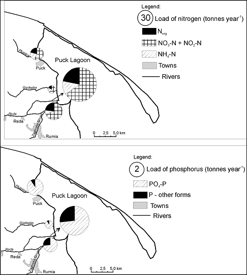
Fig. 3. Nitrogen and
phosphorus loads discharged into the Puck Lagoon from the selected rivers
Despite all of these point-source oriented
actions, nutrients levels in the Lagoon remained still high. One of the reasons
for this could be still high load of nutrients transported by the rivers (Fig.
3). An important fact is also a very high proportion of inorganic nitrogen
forms (especially nitrates) in total nitrogen, and orthophosphates in total
phosphorus load, because these nutrients species are, in particular,
responsible for stimulating eutrophication processes.
Most of the nutrients load, especially in case
of nitrogen, originated from the
Tab. 4. Contributions
of the selected rivers to the total nitrogen (TN) and total phosphorus (TP)
load discharged into the Puck Lagoon in 2006
|
River |
TN [%] |
TP [%] |
|
Zagorska Struga |
15 |
12 |
|
Reda |
72 |
65 |
|
Gizdepka |
3 |
5 |
|
Plutnica |
10 |
18 |
|
Total |
100 |
100 |
Area specific load of total inorganic nitrogen
(TIN) in 2006 was slightly higher in the
Tab. 5 Area specific loads of total inorganic nitrogen
(TIN) and orthophosphates phosphorus (PO4-P) in the selected catchments in 2006
|
Catchment |
TIN [kg×km-2×year-1] |
PO4-P [kg×km-2× year-1] |
|
Zagorska Struga |
460 |
18 |
|
Reda |
467 |
21 |
|
Gizdepka |
261 |
27 |
|
Plutnica |
357 |
46 |
|
Total |
442 |
24 |

Fig. 4. Relationship between specific runoff and TIN area specific load in the selected catchments in 2006
The analysis
proved that changes in transport of nutrients from all the analysed rivers
showed well-expressed seasonal pattern that corresponded well with hydrological
regime of the rivers. Nitrogen load was higher in winter half-year
(November-April), especially during snow-melting period in March (Fig. 6). The
lowest loads occurred in summer and in autumn, mostly in November and August,
when river flows and nitrogen concentrations were the lowest. During winter, on
average, about 60% of the annual load of total nitrogen was transported by the
rivers to the Lagoon. These seasonal changes were less pronounced in case of
phosphorus (Fig. 6), because of high TP load recorded in summer in the
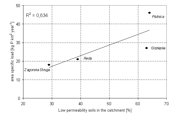
Fig. 5. Relationship between share of low permeability soils and PO4-P area specific load in the selected catchments in 2006
Tab. 6. Share of winter half-year (November-April) load in
annual nutrients load in the selected catchments in 2006
|
Catchment |
Winter half-year share
(TN) [%] |
Winter half-year share
(TP) [%] |
|
Zagorska Struga |
61 |
54 |
|
Reda |
62 |
57 |
|
Gizdepka |
60 |
55 |
|
Plutnica |
57 |
40 |
|
Total |
61 |
53 |
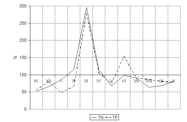
Fig. 6. Seasonal changes of total nitrogen (TN) and total
phosphorus (TP) monthly load in relation to average annual load in the selected
rivers in 2006
5.
Conclusions
The results of the research have proved that the
nutrients load transported to the Puck Lagoon by the rivers was considerably
higher than it is reported in the official documents, which are based on
standard monitoring procedures. Because of the high vulnerability of the
Lagoon, the load transported even by the small rivers may pose a threat to its
ecosystem. The influence of rivers on water quality of the Lagoon could be more
pronounced than the impact of discharges from point sources (sewage treatment
plants) also because of the fact, that this input was directed into the
shallowest part of the water body, characterised by much slower water exchange
with the open sea.
The actions oriented on the reduction of still
high specific loads of nitrogen and phosphorus should now concentrate on the
further development of sewage collection systems, on the building up and
managing stormwater systems in the urban areas, and
on the reduction of the emissions from agricultural diffuse sources in the
rural parts of the drainage basin.
References
Bogdanowicz
R., 2007, Managing water quality in the Puck Lagoon drainage basin (NATURA 2000
site), in: Proceedings of the Second International Conference on Waters in
Protected Areas, CWPC, EWA, Dubrovnik, Croatia, 129-133.
Bolalek J., Falkowska L., Korzeniewski K., 1993, Hydrochemistry of the Puck Bay, in: Korzeniewski K. (ed.), The
Kruk-Dowgiallo L. (ed.), 2004, Impact of the selected pollution
sources on the environment of the
Krzyminski W., Kruk-Dowgiallo
L., Zawadzka-Kahlau E., Dubrawski
R., Kaminska M., Lysiak-Pastuszak
E., 2004, Typology of Polish marine waters.
Coastline Reports 4, 39-48.
Lundberg C., 2005, Eutrophication
in the Baltic Sea – from area-specific biological effects to interdisciplinary
consequences, Abo Akademi
University, Abo, Finland.
Nowacki J., 1993, Morphometry of
the Puck Bay, in: Korzeniewski K. (ed.), The