1Akpambetova K.M., 2Rahmetova A.A., 3Chistova A.A.
1,3Karaganda State
University named after E.A. Buketov, Kazakhstan
2Karaganda State
Industrial University, Kazakhstan
RELIEF
OF URBANIZED TERRITORIES
OF CENTRAL KAZAKHSTAN
The object of
research in geomorphology is the relief of the earth's surface. While studying
the relief attention is paid to morphological and morphometric parameters,
investigated the genesis of relief and determined its age, composed
geomorphological map. Certain difficulties arise in the study the relief of
urbanized areas. In this article the relief of the mining region of Kazakhstan,
especially the relief of Karaganda city was described.
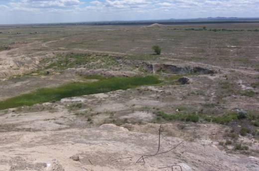
Fig.1. Karaganda is located on that kind of flat relief.
Karaganda was
formed in a place of miner settlements (Old Town) and a number of rural
localities (Big Mikhailovka, Tikhonovka, Fyodorovka, Maikuduk, Prishahtinsk). Karaganda
is characterized by dissociation and dispersion of residential areas and
industrial zones. Enterprises are located in four districts of the city -
South-East, North-East, West and North. Mines and coal industries are located
in the Northern zone, and the transportation and warehousing in the West. The
presence of limestone, sand, building stone and clay deposits has created numerous
enterprises which produce construction materials. Electroenergy supply of the
industrial areas of the region is carried out by Karaganda heat and power
plant.
Geological
structure of the territory of the city is complex and connected with the
geology of Central Kazakhstan. In general territory of the region occupies the
middle part of Paleozoides of Central Kazakhstan, including the Caledonian and
Hercynian structures. Breeds crumpled into folds, violated by faults and cracks of different
directions, intruded by intrusions. Karaganda synclinorium has been studied in
detail, which is elongated in the meridional direction. It includes about
thirty industrial areas. Middle part of the synclinorium occupies the Karaganda
coal basin. The Western part of the synclinorium is characterized by
alternating depressions and elevations formed by volcanogenic-terrigenous
thickness of the Devonian and lower Paleozoic, and also Graben-synclinoria
placed in them Samara and Zavyalovsky deposits of coal. Karaganda coal basin
has over eighty coal layers, including about fifty layers operating capacity
[2]. The qualitative composition of coal in the layers is uneven, the ash
content into them is from 10 to 40%. Large ash content associated with the presence
of layers of waste rocks. In addition to coal, the district has a deposits of
limonite (Sasyk Karasu), limestone, gypsum, marl, shale, building stone,
sandstone, marble. Mineral deposits, especially coal, put Karaganda region in a
number of the richest and most industrially developed mining regions. Thus, the
development of mineral deposits defines the formation of peculiar relief, which
is referred to the mining type. Note also, that the development of mineral
deposits contributed to the formation of certain relief processes in the area
of research.
Karaganda is
located on undulating sloping plain with marks no more than 160 m. The city
consists of two parts - the "Old Town" and "New Town". Old
Town with mines and processing plants is very extensive, and the New Town with
high-rise office buildings, universities, shopping centers is the most
comfortable district of Karaganda. Industrial district is divided by the valley
of Big Bukpa river. By the river valley
descend two ridges – Karaganda-Saransk and Karaganda- Mikhailovka
with marks of 560 and 570 meters respectively.
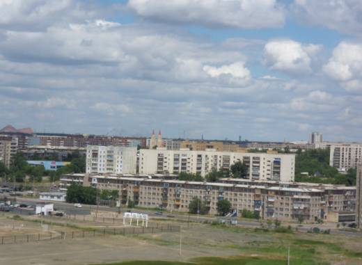
Fig.
2. South-Eastern part of the city. On the background are heaps.
The Old Town
district is a sloping plain with small hills separated by broad flat-bottomed
hollows and ruts, in which is the flow of atmospheric and mine waters. On high
smooth ridges, sloping down to the river, is a New Town. Plain Maykuduk with
small hills Ushtobe and Kosoba is located on the East. In general, the relief
of the city is favorable for the development of industrial enterprises, for
holding the housing-civil construction. Changes in the relief of the city occur
in the process of stripping operations and mining. This gives rise to open-cast
mines, pits, mines, failing funnels and waste banks. In accordance with the
technology of development on the surface the benches and terraces are created. Besides sculptural forms of relief are developing accumulative
formations, which are common on the terraces of the lower levels of open-cast
mines or occupy the area beyond. Such forms of relief are usually composed of a
material that is the result of stripping operations, crushing. On the platforms
of the benches it is possible to see the accumulative forms of relief of small
size - debris cones at the rear seams accumulated through shedding, landslides
and slumping. Resulting from quarrying technogenic forms and microforms of the
relief are subjected to the influence of the slope of exogenous processes,
which increases the water-erosion activities. Continuous exposure of
water-erosion processes on the relief are gradually leads to a smoothing and
elimination of irregularities. Modified character of the relief, the increase
of positive and negative forms create new conditions for the formation of a
microclimate.
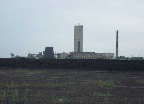
Fig.
3. Mines transform the look of the city.
Technogenesis
activates the processes of linear erosion, deflation, suffusion, formation of
gullies and scours. These and other anthropogenic changes of the relief create
new, not typical for the region's soil formation processes, chemical and
physical parameters which are in dependence on the lithology of the rocks
involved in technogenesis [1,3]. Development of the deposit of fluxing
limestone contributes to changing of the relief. At the underground mining
cracks, depression funnels appear, drawdown of surface occurs. As a result of
subsidence housing complexes might fall within the bottom of the waste
mine.
Perhaps the most
common forms of the relief of Karaganda are waste banks of conical shape. Waste
banks distributed mainly in the industrial part of the city and occupy large
areas. Since 2003 the waste rock of slagheaps used as the basis for the roads,
laid waste and abandoned mines, bore pits, ditches. Landscapes, placed in them
the mining industry have significantly increased air pollution due to
weathering of waste rock. Since the early 70s in Karaganda measures to
utilization of coal production, including extinguishing and subsequent
elimination of waste banks are implemented. A result of such works carried out
by the Department of coal, waste banks stopped to emitting smoke. Activation of
denudation processes contributed to the formation of powerful centers of
accumulation of dust. Denudation of overburden in the dumps, waste banks,
mines, quarries and subsequent migration of the contained chemical elements
with the formation of secondary habitats scattering is the cause of
anthropogenesis. At stockpiling rocks, which are extracted from the array at
the sinking of excavations on mines and pits, overburden works in the quarries
and branch cuts are formed dumping mounds. Dumping mounds can be diverse
in size and shape. Open pit seizures and waste dumps in most cases
represent a lifeless area. Erosion processes, as a result of which
incapacitates considerable amount of land, contribute to the accumulation at
the foot of the slope of the dump the accumulative material. In the city
territory there are several dumps with significant size and pollute the
environment as an area, in which it is located, and the city as a whole. As it
is visible, the strongest changes of the relief and other natural conditions of
the city caused by human activities. Development of mineral deposits,
artificial alignment of relief for construction of roads, the presence of
quarries and bore pits without their subsequent recultivation, flooding of
relief by exhaust mine waters, the presence of closed mines without their
subsequent recultivation, the presence of waste rock dumps have led to
waterlogging, flooding and subsidence of the most part of relief of the
territory of Karaganda.
Currently,
South-East district is one of the ecologically clean areas of Karaganda. The relief is lightly wavy, crossed by
small ravines and ditches. Along the ditches stretched pipe of heating plants.
Out of the four artificial reservoirs available in Karaganda and satellite
towns, one is located in the region - Fedorovskoe reservoir.
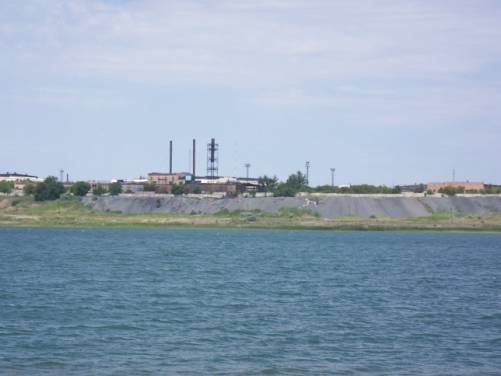
Fig. 4. Fedorovskoe reservoir.
In modern
conditions the territory of the reservoir is used as a recreational area for
the population. The South-Eastern area of the city does not have in its
territory the industrial enterprises. Here are the mostly university academic
buildings, shopping centers, hotels, hospitals, parks, ski-storage, cinemas. Is
carried an intensive construction of multi-storey residential arrays and
cultural centers.
References:
1. Akpambetova
K.M. The impact of technogenic load on the relief development //
Modern problems of ecology in Central Kazakhstan: collection of scientific
works., Karaganda 1998, p.66-72
2.
Kushev G.L. Karaganda coal field. – Alma-Ata,
1963
3.
Impact assessment of the ash dump on the
components of the environment // PTD report of HES-1. Karaganda, 2000