The effects of extreme rainfall events on agricultural foothill slopes in the Wiśnicz Foothills
Jolanta
Święchowicz
7 Gronostajowa Str, 30-387
Cracow, Poland
Abstract:
Extreme
rainfall events have the potential to cause intensive transformation of slopes
surfaces and significant damage to agriculture. This paper presents the geomorphic
and economic effects of three extreme rainfall events which took place at the
Key words:
extreme rainfall events; soil erosion; rill erosion;
Carpathian Foothills; southern
Introduction
Soil erosion resulting from rainfall
is usually most noticeable and spectacular during extreme events like local
heavy downpours. In the temperate climate zone, agricultural slopes, devoid of
natural vegetation cover, react very quickly to short-duration,
high-intensity rainfall events and are one of the most dynamically developing relief forms especially
in uplands and foothills (Olecki 1970; Teisseyre 1992, 1994; Smolska 1996,
2006; Starkel 1997; Gil 1998; Janicki and Zgłobicki 1998; Rodzik et al.
1998; Stankoviansky 2002; Szpikowski 2002; Cerdan et al. 2006). Soil erosion
rarely happens on all the slopes in a catchment simultaneously and its
intensity is differentiated along the longitudinal profile of the slope
(Święchowicz 2000, 2004). Soil loss from farmland causes the reduction of the
thickness of soil layer leading at times to its complete removal. Erosion not
only causes permanent impoverishment of soil and the reduction of crop yield,
but also makes farming difficult, and sometimes it permanently damages large
land areas (Clark, Havercamp, Chapman 1985; Józefaciuk,
Józefaciuk 1996; Morgan 1995; Rejman and Rodzik 2006). Additionally,
if the cultivated fields are adjacent to built-up areas, those areas are likely
to suffer damage as well (Auzet et al. 1990; Boardman 1995; Boardman et al.
2006; Stankoviansky et al. 2006). The aim of this paper is to present geomorphic and
economic effects of three extreme rainfall events in the hydrological years 2002,
2005 and 2006 on agricultural fields on the
Study area and methods
The paper
uses the results of research carried out in the lowest
part of the Carpathian Foothills, where the Field Research
Station of the
The study was carried out
in 2002-2006 on the basis of mapping of selected results of extreme rainfalls,
which took place on the

Fig. 1. Location of the study area.
The estate covers the area
of 103 ha. The soils are weakly differentiated. The majority of them are
pseudogley soils (Stagnic Luvisols) developed from lessive soil (Haplic
Luvisols) (Klimek 1995). In hydrological years 2002-2006, almost 86% of the area was
arable land, which was used for crops like winter wheat, winter rape and
sugar-beet (Fig. 2).
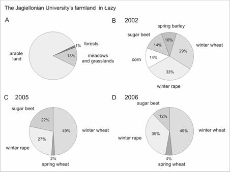
Fig. 2. The
B – agricultural land pattern in 2002, C –
agricultural land pattern in 2005,
D – agricultural land pattern in 2006.
The analysis of the data
collected at Meteorological Station in Łazy (Fig. 1) in
hydrological years 1987-2006 makes it possible to assess the role of extreme rainfalls in
slope transformation.
Extreme precipitation events
Mean annual
precipitation from 1987 to 2006 amounted to 656.9 mm. Annual precipitation
totals varied from almost 800 mm (1998, 2001) to 433.4 (2003) (Fig. 3a).
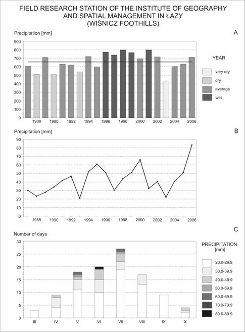
Fig. 3. The characteristics of precipitation in
hydrological years 1987-2006 (Łazy Research Station). A - annual precipitation totals, B - maximum daily precipitation from 1987-2006, C - number of days with daily amount of
precipitation above 20 mm, 30 mm, 40 mm, 50 mm, 60 mm, 70 mm and 80 mm in
hydrological years 1987-2006.
There were an
average of 167.1 days with precipitation in the hydrological years from 1987 to
2006. Dominant were days with very weak (0.1-1 mm) and weak (1.1-5.0 mm)
precipitation and they constituted 76.5% of all the days with precipitation.
Days with strong and very strong precipitation (above 20.0 mm) constituted only
3.3% of all the days with precipitation and occurred mainly in the summer
half-year. Maximum daily precipitation in a year varied from 21.0 mm in 1993 to
83.4 mm in 2006 (Fig. 3b). During 20 years of observation
(1987-2006) rainfalls of daily sums over 40 mm took place 17 times and happened
mainly in June (9) when the majority of slopes were sufficiently covered by
vegetation. The rainfalls of daily sums over 50 mm took place four times and
happened only in June. The rainfalls above 60 mm took place only twice in May
and in July and the rainfall of daily sum of 83. 4 mm (rain gauge) took place
only once (Fig. 3c).
Slope
transformation during the extreme rainfall events
Hydrological year 2002
In
2002, 14% of the agricultural land of the university’s farmland was sugar-beet,
which was sown in mid-April. The plants germinate within 7-20 days after
sowing, and the first leaves start to appear within 7-10 days after
germination. When plants form four leaves, they are thinned. As a result,
distances between the plants in a row are 20-25 cm. Consequently, the period
during which the cultivated land is devoid of a protective cover of leaves is
quite long.
On
the 29th of May there was rainfall of the amount of 40.2 mm. The result of the
rainfall was among others a system of erosion rills, which joined and became
the main route for transport of water and soil material. In June there were
three intensive rainfalls; of the amounts of 42.7 mm (10-11th June), 30.1 mm
(24th June) and 29.2 mm (28th June). After the rainfall of 28th June, the
length of the main rill was 30 m, and its maximum depth was 68 cm. On the 16th
July there was another rainfall with the amount of 40.4 mm and its initial
intensity within the first 15 minutes was almost 1.3 mm/min (Fig 4a,b).

Fig. 4. The characteristics of precipitation in hydrological
year 2002 (Łazy Research Station) and the morphological results of
intensive rainfall which took place on 16 July, 2002. A – daily precipitation
totals in July 2002, B – precipitation total and mean intensity on 16 July,
2002, C – rill on the sugar-beet field in the Dworski Stream catchment, D –
deluvial fan in the footslope part of the sugar-beet field in the Dworski
Stream catchment, E – selected cross sections of the eroded rill
on the sugar-beet field.
As
a result of linear slope wash, the main rill deepened to maximum 120 cm and
widened in its middle and lower section (Fig. 4c, e; Święchowicz
2004). There was also removal of parts of soil material which broke off its
edges and the shift of the eroded rill up the slope. The deluvial fan was built
up (Fig. 4d).
Such
results were seen only on land with sugar-beet crops. On the remaining slopes
the erosion was insignificant. The eroded material was accumulated in the
footslope deluvial plain above the edge which separated it from the valley
bottom. The deep rill was an incidental example of the results of linear slope
wash on the slope in the catchment. Its formation was a consequence of a
rainfall of a significant amount (daily total slightly above 40 mm) which
occurred in the initial stage of the plant growth and of sowing of one type of
crop on a significant area of the field. Subsequent rainfalls of high amounts
and intensities led to the deepening and widening of the existing form
irrespective of the vegetation cover (Święchowicz 2004). The eroded
rills functioned only in the vegetation season and were removed by tillage.
Hydrological year 2005
In
2005, the dominant crop on the
Fig. 5. The characteristics of precipitation
in hydrological year 2005 (Łazy Research Station). A - daily precipitation totals in June 2005, B - daily precipitation totals in July 2005, C - daily precipitation totals in August 2005, D - daily precipitation totals in September 2005.
The
result of the rainfall was the deep rill, which became the main route for
transport of water and soil material. The deep rill formed only on one location
on the field with sugar-beet crop, namely along a cart road going downslope. After
the rainfalls which took place in June the maximum depth of eroded rill was
95.5 cm. The rill was active during the subsequent heavier rainfalls and was
deepened during the rainfalls in July, August and September (Fig. 5). As a
result of linear slope wash the rill deepened to maximum 200 cm and widened in
its upper and middle section. There was also removal of parts of soil material
which broke off its edges and the shift of the rill up the slope. The deluvial
fan was to built up. Such a deep eroded rill was the only example of his type
observed on the university’s arable land since 1987 (Fig. 6).
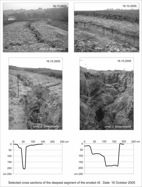
Fig. 6. The geomorphic results of intensive rainfall
which took place in 2005.
Hydrological year 2006
The transformation on the slopes took place on
17th June 2006 during rainfall of the amount of 83.4 mm, which lasted only 85
minutes and its maximum intensity was slightly above 3.8 mm.min-1
(Fig. 7).
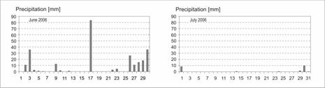
Fig. 7. The characteristics of precipitation in
hydrological year 2006 (Łazy Research Station).A - daily precipitation totals in June 2006, B - daily totals precipitation in July 2006.
The rainfall caused intensive surface flow on the
field with sugar-beet, which covered 12% of the crops in 2006. On one plot on
the area of about 0.5 ha, all the plant seedlings were washed away together
with the eroded soil. On the remaining fields with sugar-beets, the crops were
silted up and consequently the yields were reduced. The results of the extreme
rainfall were most visible on the grape-vine field. The vineyard was started in
spring 2005 on the area of 0.3 ha. In spring (May) 2006 grape-vines were
planted on additional 0.7 ha. Thus in June, when the rainfall took place, 0.7
ha of the vineyard was devoid of vegetation cover. Between the rows of
grape-vine (which were 2.5 m apart) an intensive surface flow took place in
several sections. Along the rows of grape-vine there formed rills which were
most often several to over ten cm deep (Phot. 1). The eroded material was
accumulated in the footslope deluvial plain above the edge which separated it
from the valley bottom (Phot. 2). On the land with cereals there was intensive
surface flow. However there wasn't intensive slope wash because of the dense
vegetation cover.
Economic
results of the extreme rainfall in 2006
Extreme
rainfalls not only cause a change in the relief and profile of slopes, leading
to the build-up of footslope deluvial plains but also cause financial losses
and economic damage. The immediate result of thunderstorm rainfalls and heavy
downpours may be damage to the natural land forms and to farm buildings or
infrastructure faclities. The extreme rainfall event with 83.4 mm within 85
minutes and maximum intensity of 3.8 mm.min-1, which took
place in June 2006 caused a lot of damage on the
The
insignificant damage was caused to fields with winter wheat which in 2006 was
the dominant crop and covered almost 49% of the arable land. Considerable
silt-up of crops took place only on fields with spring wheat, and consequently
the crop yield was lowered from 5.5 t.ha-1 in 2004 to
only 2.0 t.ha-1 in 2006. However, due to the small area
of that crop (2%), the damage to the cereals were only a small portion in the
total damage the farm suffered in 2006 as a result of one extreme rainfall.
Despite high intensity of the rainfall and the accumulation of the washed-off
soil in the footslope area covered by the vineyard, there was no damage to the
grape-vine plants (Phot. 1 and 2).
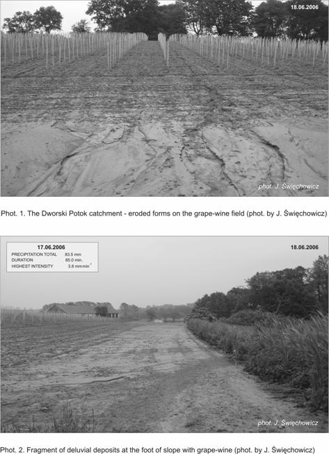
Water flowed freely between the rows forming in several sections erosion
rills several to more than ten cm deep.
The
remaining financial losses resulted from the damage to technical structures or
facilities. The pond’s dikes (c and d) and the fence (e) were destroyed and
flood waters covered the area of 1ha (f), which later had to be drained (Fig.
1).
The role of extreme
precipitation on slope transformation in the Carpathian Foothills
Short torrential rains play a
decisive role in relief transformation in the Carpathian Foothills because
during such events substantial amount of soil is transported. Not all relief
forms are equally transformed. Top hill areas are least affected, the slopes
and valley bottoms – much more. The results obtained confirm regularities
occurring in other areas that severe erosion is more intensive when large areas
of land are cultivated for one type of crop like sugar beet, rape or corn
(Teisseyre 1992, 1994; Rodzik et al. 1998). The examples of erosion as
presented in this article happened on one of only a few big farms which use
large-scale intensive agriculture in the Wiśnicz Foothills. During the
study area, the majority of the farm were arable fields (86%) used for
sugar-beet, rape or corn crops. It was the sugar-beet field that underwent the
most intensive slope transformation which resulted in the formation of rills
and gullies, and the accumulation of deluvia in the footslope areas. New
erosive forms were not permanent as they were removed by tillage after the
sugar-beet harvest. However, soil eroded from the field was permanently
accumulated in the form of deluvial fans at the foot of the slope or in the
valley bottom.
When the slopes are separated from
valley bottoms with a distinct edge, the eroded material is accumulated in form
of deluvial fans above the edge. It
causes a buildup and widening of footslope parts. A clear morphological
contrast between the slopes and the bottom of the valley is thus created. When
the slopes gently transform into valley bottoms without a distinct edge and the
land is ploughed up and down slope, the deposition of the
material at the foot or in the valley bottom causes lengthening of the concave
sections of the slope and as a result morphological contrasts between the
slopes and the valley bottom become blurred (Święchowicz 2002, 2006).
It is worth emphasising that in the Carpathian
Foothills dominant are small farms which cover the area of 3 ha on average and
are divided into several plots. The adjacent plots are differently used.
Foothill areas, due to short and gentle slopes and low infiltration of soil cover,
have a longitudinal pattern of plots without stable transverse boundary strips.
A stable pattern of small plots separated by boundary strips limits the
effectiveness of erosion (Święchowicz 2002). On the other hand, as
research carried out in
Conclusions
Soil erosion
may be a slow process which takes place seldom and continues relatively
unnoticed. Only sporadic short-duration and high intensity rainfall events may
trigger severe soil erosion causing serious loss of topsoil. The process leads
to significant changes of the forms already present on the slope and to the
formation of rills and gullies, and the material transported down the slope is
accumulated at the bottom on the foodslope plains or in the valley bottom in
the form of deluvial fans. Deposition of the material at the bottom of the
slope and in the valley bottom leads to the elevation and extension of the
valley bottom and at the same time it hinders transport of the solid material
from the slope to the channel. Slope-channel coupling and sediment supply is
only local and episodic.
However,
erosion forms which formed as a result of soil erosion on the slopes were not
permanent. They occurred only in the vegetation season and were removed by tillage.
Soil erosion rarely happens on all the fields simultaneously and its intensity
is differentiated along the longitudinal profile of the slope. In the
transformation of slopes a greater role is played by land use, the area of
crops and how big the crops are during the rainfall rather than by the
parameters of rainfall. Rainfall of the same parameters (amount, intensity and
duration) causes different results depending on land use. Soil resistance to
erosion depends on the type of crops and spatial crop structure.
The loss of
soil from farmland may be reflected in immediate loss of crop and reduction of
yields in the longer term. However the immediate losses or damage do not always
have to be the result of extreme rainfall only. Sometimes a greater influence
on the size of damage in agriculture may have type of crops and weather
conditions (temperatures and rain) just before the occurrence of intensive rainfalls
or immediately afterwards.
Acknowledgements
Thanks
are due to Alicja Waligóra-Zblewska for preparing the English
translation of the paper and Adam Kiszka the head of
References
Auzet A.V.,
Boiffin, J., Papy, F., Maucorps J., Ouvry, J.F. (1990), An approach to the
assessment of erosion forms and erosion risk on agricultural land in the
northern Paris Basin, France, in Boardman,
J.B., Foster, I.D.L., Dearing, J.A. (eds.) Soil Erosion on Agricultural Land,
John Wiley & Sons, 384-400.
Boardman, J.B.
(1995), Damage to property by runoff from agricultural land, South Downs,
southern
Boardman, J.B.,
Verstraeten, G. and Bielders, Ch. (2006), Muddy floods, in Boardman, J.
and Poesen, J. (eds.) Soil erosion in Europe, John Wiley & Sons,
743-755.
Cerdan, O., Poesen,
J., Saby, N., Le Bissonnais, Y., Gobin, A., Vacca, A., Quinton, J., Auerswald,
K., Klik, A., Kwaad, F.F.P.M. and Roxo, M.J. (2006) Sheet and Rill Erosion,
in Boardman, J.B. and Poesen, J. (eds.) Soil erosion in Europe, John
Wiley & Sons, 501-513.
Gil,
E. (1998), Spływ wody i procesy geomorfologiczne w zlewniach fliszowych
podczas gwałtownej ulewy w Szymbarku w dniu 7 czerwca 1985 roku, in
Starkel, L. (ed.), Geomorfologiczny
i sedymentologiczny zapis lokalnych ulew, Dokumentacja Geograficzna IGiPZ PAN, 11: 85-107.
Janicki, G. and Zgłobicki, W. (1998),
Geomorfologiczne skutki ulewy (z 16 września 1995r.) w okolicy Garbowa na
Wyżynie Lubelskiej, Annales Universitatis Mariae Curie-Skłodowska
Lublin-Polonia, Sectio B, 53/6:109-129.
Józefaciuk, Cz. and
Józefaciuk, A. (1996), Erozja i melioracje przeciwerozyjne,
Biblioteka Monitoringu Środowiska, Warszawa.
Klimek, M. (1995),
Charakterystyka pokrywy glebowej eksperymentalnej zlewni Dworskiego Potoku
(Pogórze Wielickie), in Kaszowski, L. (ed.) Struktura i funkcjonowanie środowiska przyrodniczego Progu Karpat,
Zeszyty Naukowe UJ, Prace Geograficzne 100: 99-111.
Morgan, R.P.C.
(1995), Soil Erosion and Concervation, Longman.
Olecki, Z. (1970), Przebieg i skutki silnej
ulewy w dniu 29 maja 1968 roku w Gaiku-Brzezowej, Studia Geomorphologica Carpatho-Balcanica, 4:101-105.
Rejman, J. and
Rodzik, J. (2006),
Rodzik, J., Janicki, G., Zagórski, P.
and Zgłobicki, W. (1998), Deszcze nawalne na Wyżynie Lubelskiej i ich
wpływ na rzeźbę obszarów lessowych, in Starkel, L. (ed.) Geomorfologiczny i sedymentologiczny
zapis lokalnych ulew, Dokumentacja
Geograficzna IGiPZ PAN, 11: 45-68.
Starkel,
L. (ed.) (1997), Rola
gwałtownych ulew w ewolucji rzeźby Wyżyny Miechowskiej (na
przykładzie ulewy w dniu 15 września 1995 roku), Dokumentacja Geograficzna IGiPZ PAN, 8: 1-108.
Smolska, E. (1996), Funkcjonowanie systemu korytowego w obszarze
młodoglacjalnym na przykładzie górnej Szeszupy (Pojezierze
Suwalskie), Uniwersytet
Warszawski. Wydział Geografii i Studiów
Regionalnych. Warszawa.
Smolska, E. (2006),
The impact of extreme rainfalls on slopes in the Suwałki Lakeland area (NE
Poland) based on soil erosion measurements, in Jania, J. and Kundzewicz, Z.W.
(eds.) Extreme hydrometeorological events
in Poland and their impacts – European context, Sosnowiec - Warszawa,
132-134.
Stankoviansky,
M. (2002), Bahenné povodne – hrosba úvalín a suchych
dolín, Geomorphologia Slovaca, 2: 5-15.
Stankoviansky, M.
(2006),
Szpikowski,
J. (2002), Contemporary processes of soil erosion and the transformation of the
morphology of slopes in agricultural use in the postglacial catchment of the
Chwalimski Potok (upper Parsęta, Drawskie Lakeland), Quaestiones Geographicae,
22: 79-90.
Święchowicz,
J. (2000), The threshold conditions for slope wash processes in the Foothill
catchment (Carpathian Foothills,
Święchowicz,
J. (2002), Linkage of slope wash and sediment and solute export from
a foothill catchment in the Carpathian Foothills of South Poland, Earth Surface Processes and Landform,
27/12: 1389-1413.
Święchowicz,
J. (2004), Rola procesów ekstremalnych w transformacji stoków
pogórskich (na przykładzie Dworskiego Potoku), in Izmaiłow, B.
(ed.), Przyroda – Człowiek –
Bóg, Instytut Geografii i Gospodarki Przestrzennej UJ,
Kraków, 83-91.
Święchowicz, J. (2006), The role of precipitation on slope
transformation in the Carpathian Foothills (Poland), Geomorphologia Slovaca,
2: 5-13.
Teisseyre, A.K. (1992),
Epizodyczne koryta a rozwój suchych dolin w krajobrazie rolniczym, Acta
Universitatis Wratislaviensis, Prace Geologiczno-Mineralogiczne, 31, 1-69.
Teisseyre, A.K. (1994),
Spływ stokowy i współczesne osady deluwialne w lessowym
rejonie Henrykowa na Dolnym Śląsku, Acta Universitatis
Wratislaviensis, Prace Geologiczno-Mineralogiczne, 43, 1-218.