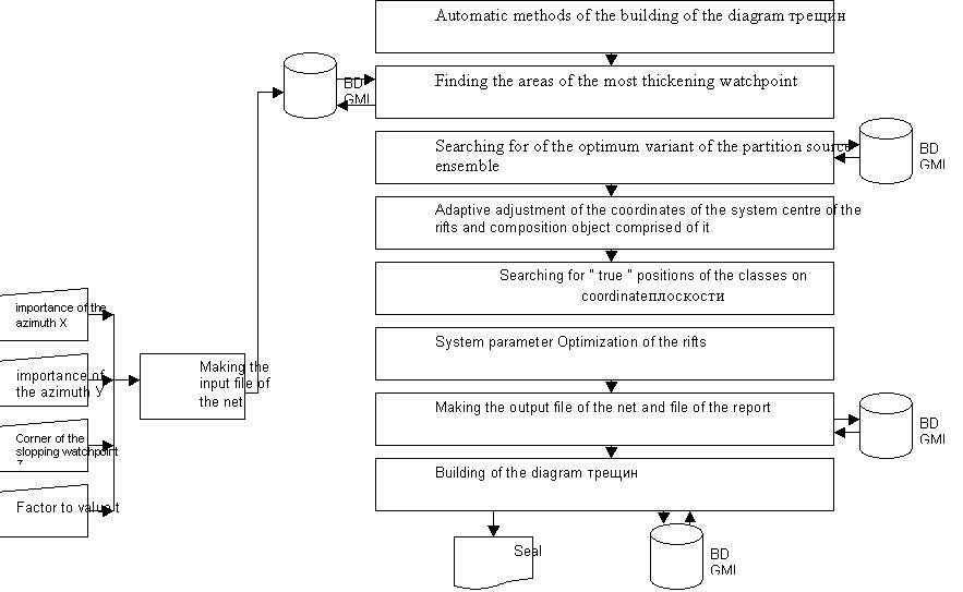
Drawing 1- Block - a scheme of the algorithm of the
automatic methods of the building of the diagram трещиноватости
M.B.Nurpeisova,Kasimhanova H.M.,A.Sh.Bek, G.M.Kyrgizbaeva.
Kazakh national tehnicheskby
university of the name K.I.Satpaeva, Almaty, Republic Kazakhstan, Marzhan-Nurpeisova@rambler.ru
METHODS
OF THE SEPARATION OF THE ACTIVE SYSTEMS Of THE RIFTS WITH USING
GIS-TECHNOLOGIES
В статье рассматривается методика выделения
систем трещин по данным натурных наблюдений с применением ГИС-технологии на
основе использования базы данных геолого-маркшейдерских информаций.
Methods of the separation of the systems of the rifts is considered In
article as of натурных of the observations with using
GIS-technologies on base of the use database геолого-маркшейдерских information.
The Methods of the
measurement трещиноватости
mountain sorts are reduced basically to direct measurements in denuding on
surfaces, escarpment in quarry, on wall шурфов and mountain productions, observations on кернам of the geological
bore holes. On opened development under it is enough big area of the denuding
the mountain sorts the most efficient method direct measurements (the mass замеров) by means of
mountain compass or фототеодолитом. Big
amount of the measurements is accumulated At study трещиноватости. Processing and
generalization of these measurements produce with use circular, square-wave
diagrams and стереограмм трещиноватости, on the grounds
of which build the structured cuts and cards трещиноватости. The Square-wave diagrams allow to
quantify the systems of the rifts on each замерной of the stations, on quarry as a whole,
prevalence that or other systems of the rifts, elements their залегания , 211-214.
The System of the
rifts is accepted name the ensemble of the rifts, located approximately
parallel for a certain axis. We shall Elaborate the volume of the broughted
notion for formalized description in coordinate system azimuth простирания - a corner of the
fall. From determination follows, first that system of the rifts consists of
separate rifts, spatial position which is uniquely defined two parameters by
azimuth простирания and углом of the fall. In
coordinate system azimuth простирания and
corner of the fall are displayed in the manner of points and hereinafter their
shall name the observations. Secondly, system of the rifts has an axis, spatial
position which is also described two parameters - an azimuth her(its) простирания (А) and углом of the fall (δ
). Since axis of the system of the rifts is displayed in the manner of points,
shall name her(its) hereinafter system centre of the rifts. V-tretiih, all
rifts, being included in systems of the rifts, must be approximately parallel
her(its) axis that is to say difference between importances parameter centre
and observations must not exceed certain value, within which they can be
considered parallel. Now with provision for brought revision shall formulate the
profound statement of the problem of the separation of the system of the rifts
as of натурных of the
observations
Statement of the
problem. On base got in process of the field observations given necessary to
select the systems of the rifts according to the following критериям:
" deflection
of the position of the separate observations from system centre of the rifts
must not exceed certain given value (the condition параллельности);
" amount of
the observations, united in system, must be not certain critical value less,
providing validity got result (the condition to representativenesses).
Mathematical
statement of the problem. For mathematical statement of the problem of the
separation of the system of the rifts as of field observations we shall enter
the following indications:
The Attitude between object analysed ensemble (the
point of the observations) Z is defined by square-wave diagram трещиноватости (HOY). On axis
are OH postponed importances of the azimuth простирания (A), on Oy - a corner of the slopping (
), but position watchpoint can be is uniquely presented regular discrete
function of the following type:
Z= f(h,y,t), (1)
where h, beside - current importances of the azimuth простирания and corner of the
slopping of the point on-блюдения Z; t -
an amount of the rifts, fixed in given watchpoint that is to say factor to
value (density).
Hereinafter this parameter for brevity shall name
value of the point nablyudeniya. t reflects the actual amount a trace rifts
with importances of the azimuth простирания, equal h and corner of the slopping
beside, which were fixed in the course of field observations.
On modern stage of the development of the research
progress, due to broad introduction in practical person of the computing
machinery, decision on a matter of the processing result mass замеров element залегания rifts, left on
qualitative level. The Designed methods of the automatic building of the
square-wave diagram of the rifts, block -a scheme which is brought on drawing
1.
Drawing 1- Block - a scheme of the algorithm of the
automatic methods of the building of the diagram трещиноватости