Arkadiusz
Niewiadomski
Department of Soil Science and Geoecology, University
of Łódź, Poland
Structural and functional changes of geographical
environment in the area of former sulphur mine in Machów (Poland)
INTRODUCTION
Environment changes made by humans were documented already in 19th century and applied to the growth of earth surface deformations caused by economic expansion. In this aspect are signed the researches of environment and landscape transformations made in the beginning of 20th century in England and Germany. On remark deserve the papers by Robert Lionel Sherlock [15] and Edwin Fels [6, 7] which prove the influence of various types of human economy on environment. Similar researches were made for different areas in Poland [3, 5, 13, 14, 16]. For presentation of this themes fits the area of now liquidated sulphur mine in Machów, which was the biggest opencast sulphur mine in Europe. On its ground significant structural and functional changes of environment took place. The result was the area character and image transformation from agricultural through industrial to aquatic–recreational.
In the
researches of human influence on environment more an more often the
conservation of nature resources and its rational economy has very important
value [1, 2, 4]. This aspect has significant meaning in the issue of
environment restoration understood as homeostasis process and reclamation
effect which aim is to restore possibly best properties of degradated areas
[11].
RESEARCH AREA AND METHODS
Sulphur deposits
near Tarnobrzeg were discovered in early 50. of the 20th century.
The area of Machów mine is located in south–eastern Poland in
Podkarpacie region between Wisła and San rivers. Whole ground is situated
between 50°34’30” and 50°28’30” of north latitude and between 21°35’ and
21°43’30” of east longitude. The exact location of research area was presented
on figure 1.
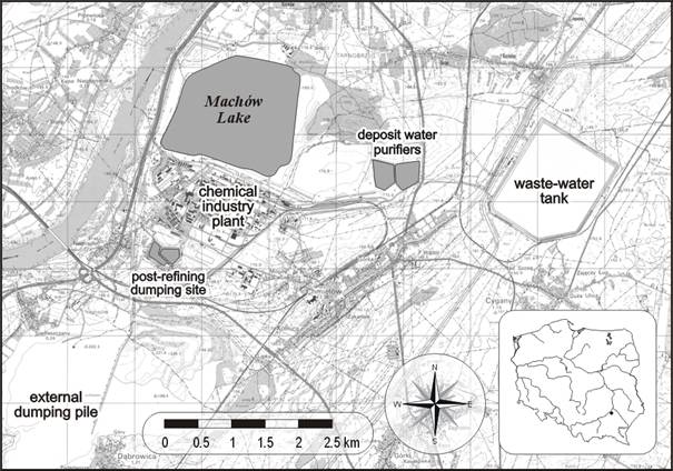
Fig. 1. The
location of sulphur mine “Machów” and chemical plant with biggest
industrial objects.
The
general surface belongs to “Machów” mine areas – the excavation,
external dumping pile, sulphur processing industry plants and directly adjoined
grounds comes to over 50 km2. The mine was founded in late 50. and
functioned on this area based on opencast method in years 1964–1992. From the
mine closure the liquidation works are provided to be aimed at aquatic
development of excavation with recreational destination. The recreational usage
is planned also for several surrounding areas. Other fragments of degradated
grounds in the area of “Machów”
sulphur mine are progressively reclamated in woodland and agricultural
direction or keeping primary functions. The development venture of old mine
excavation as a water reservoir is now in realization. The form with average
depth of about 85–90 meters was sealed up with 25–30 meters of local clay
rocks. It is supposed to prevent the salty, acidic underground waters
infiltration. From the beginning of February 2005 the filling of the tank with
water taken from Wisła river was provided. At this moment the artificial
lake is brimmed and there are works on the top of the tank executed to prepare
this area for the introduction of recreational function.
Researches
of environment changes were based on old cartographic materials,
orthophotomaps, photos, pictures and field observations. As a main aim of the
work the determination of area anthropogenization level was placed. The aim was
executed upon modified Maruszczak’s environment transformation index [10]. This
measure was counted as a relation between summary share of natural and
anthropogenic grounds in total research area. Additionally for better
presentation of study area changes the coverage of technical development was
shown. For unification of results interpretation the area was divided into 170
square basic fields with surface of 0,25 km2. This division was presented
on figure 2.
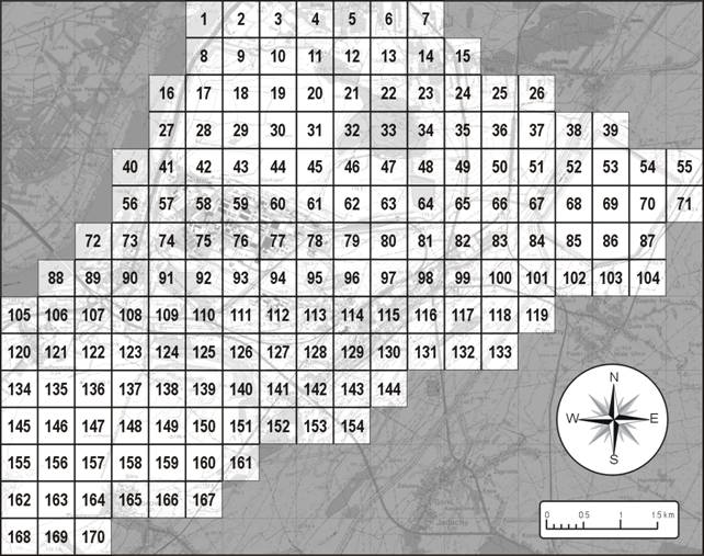
Fig. 2.
Study area basic fields division.
The study contains the area transformation analysis made in terms of structure and functions changes, that were seized in land use forms changes for several time periods. This issue was presented in table 2. Executed analysis attract attention on 2 main aspects: 1. functional – as a result of functions changes in development and 2. structural – which considers new form of the earth surface, increase of industry buildings and infrastructure with decrease of green areas. Results were presented for 4 time moments: 1940 – before the mine location, 1960 – at the beginning of mining process, 1980 – at the highest growth of mining, 2006 – after the mine liquidation. Author made also the perspective of land use in the year 2020, presented as effect of planned and carried reclamation procedures. Computer planimetry techniques were used for particular land use forms surface calculations. Present work contains additionally the quality factor of environment changes which applies the physical and chemical properties of each element of natural environment.
RESULTS
Before the beginning of sulphur mine
building described area served agricultural function working on south edge of
small town with couple thousand population. The discovery of sulphur deposits
in the early 50. caused rapid development of Tarnobrzeg and turned to many
industrial forms established on the researched area. The largest of these forms
presents table 1.
Tab. 1.
Main objects of mine infrastructure on the study area.
|
OBJECT |
SIZE [km2] |
|
- Mine excavation |
ca. 9 |
|
- External dumping ground |
8.8 |
|
- Postindustrial water tank |
2.6 |
|
- Deposit water purifiers |
0.3 |
|
- Post–refining dumping site |
0.4 |
Quick growth of such forms effected critical changes of area structure. It is worth to be added that development of mining ground caused displacement of local population. The settlement structure of the region was simplified by the liquidation of Kajmów village on which territory the excavation of new founding mine was located. Former agricultural areas became fallows and wastelands during the years. Part of them is not cultivated until today.
Along
with increase of mining area the amount of produced and emitted directly to
environment pollutants strongly grew. The most dangerous in consequences were
dusts and gases emitted to atmosphere like for example: sulphuric dust, sulphur
dioxide and trioxide, mists of sulphuric acid, fluorine compounds, nitric and
carbon oxides [8]. The obligatory air quality norms in the range of mentioned
compounds were frequently exceeded. Negative influence on the environment was
emblazoned in reduction of cultivable plants crop caused by many vegetation
diseases. Similar situation concerned the deterioration of ground water and soils
stand. Degradation of soil cover caused the decrease of quantity and quality of
biomass produced by ecosystems. In some places it led to flora cover
deprivation. Thanks to area reclamation connected with alkalization the return
of soils initial stand was noticed. Present situation shows that soils situated
near the old sulphur mine are not contaminated and their physiochemical stand
is resembling to areas where sulphur mining and processing caused no influence.
It is confirmed by multiple of physical, chemical and biological researches
among others by Niewiadomski [12]. The range of industry interaction on air and
water also was large but variable in volume and time. That is why the global
effects of interactions were smaller. Liquidation of mine and limitation of
processing powers has consequently decreased. The quantity of pollutions and
their values over the permissible concentrations are nowadays not noticeable.
Largest
sizes of natural environment degradation were observed within the earth surface
and soil cover. The mine excavation caused permanent dewastation of soils in
the area of 9 km2. Adding to this the results of changes made on the
ground of new builded infrastructural forms we get acquire total area of about
21,5 km2. Opencast mine development pressurized on earth relief. New
forms founded through over 25 years of mining and chemical industry activity
influenced mostly on changes of the surface. The excavation comprised the
average 85–90 meters and maximum 135 meters deep cavern. The external dumping
ground, where the useless rock matter was deposited, has created the pile of 60
meters average height. The largest wastewater tank height comes to 18,5 meters.
All of these forms violated the image of flat area of Wisła river high
inundation terrace.
Structural
and functional changes of environment that were made on the area of former
sulphur mine in “Machów” include big part of the whole region. The
possibility of size changes prediction and also their consequences has
essential meaning for spatial planning and politics [1]. Changes made in the
last dozens of years in studied area are assembled in tabelaric form and
presented below in table 2. They are visualising the participation of
individual anthropogenic forms of land use as a result of growth and decline of
sulphur mining and processing industry with the perspective of land use in the
year 2020.
Tab. 2.
Changes of land use in the area of “Machów” mine.
|
FORMS OF LAND USE |
YEAR |
||||
|
1940 |
1960 |
1980 |
2005 |
2020 |
|
|
6.92 % |
6.82 % |
7.05 % |
9.64 % |
5.64 % |
|
Water
areas
|
4.73 % |
4.73 % |
4.86 % |
9.41 % |
9.74 % |
|
Woodland
– recreational areas |
– |
– |
– |
– |
5.65 % |
|
Agricultural
– woodland – recreational areas |
– |
– |
– |
– |
6.02 % |
|
Industrial
areas |
– |
5.96 % |
20.01 % |
3.25 % |
3.25 % |
|
Settlement
areas |
7.42 % |
7.51 % |
8.14 % |
8.25 % |
8.25 % |
|
Agricultural
– woodland areas |
– |
– |
– |
8.44 % |
2.57 % |
|
Wastelands |
– |
– |
1.64 % |
5.14 % |
– |
|
Recreational
grounds |
– |
– |
– |
– |
2.85 % |
|
Agricultural
grounds |
80.93 % |
74.97 % |
58.29 % |
55.87 % |
56.04 % |
Based on executed research it was
showed that the land use structure underwent diversification during the years.
In the year 1940 on the study area only four forms of land use were occurred,
when in year 2006 already seven. In relation with provided area reclamation
some of the infrastructure objects like the dumping ground or wastewater tank
conferred two or even more functions. Part of agricultural areas has
considerably decreased as a consequence of succesive shut down of arable
grounds for the increase of fast growing excavation area. Developing mining
industry achieved the apogee around 1980. In spite of land use diversification
the character of changes has to be acknowledged as negative cause of
significant relief degradation and anthropogenic transformation of landscape
[1, 2, 8, 16]. The area of the studies was also deprived of vegetation. The
original landscape harmony presenting this surface as a dense agricultural
riverside area was destructed. Following systematic restriction of mining and
in effect mine closing with area reclamation caused the decrease of industry
participation in the land use structure. It was ascertained by the growth of
wastelands then transformed mostly into different reclamation grounds. Effect
of this processes was the increase of water areas and green areas participation
in connection with transformation of mine excavation into water reservoir and
development of degraded grounds into woodlands and agricultural areas. The
forecast for the year 2020 includes the ending of reclamation works around
2010. For this time period the maximum functional and structural land use
diversity is predicted. It is worth of attention that industrial function will
be constantly present because of the sulphur processing plants producing the
phosphoric fertilizers based on the imported material. They will be functioning
even through next 50 years.
Almost 30 years of mining and
processing industry activity caused expansion of infrastructure objects on the
study area. Before the sulphur industry period the road network was short and
its summary length has not exceeded 40 km. In the year 1980 the road length has
come to over 100 km including mine internal roads. In 2006 it was ascertained
that on the area existed over 80 km of different range roads. Apart from roads
the participation of other networks like electric energy, gas mains and water
supplies increased. Growth was noticed also in buildings contribution mainly in
connection with sulphur processing industry and fertilizers plant. Total
participation of technical development on the research area presents the figure
3.
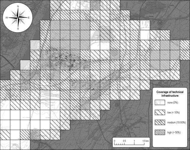
Fig. 3.
Coverage of technical infrastructure near the sulphur mine in Machów.
Changes
made by reclamation treatments after the mine shut down influenced positively
on the possibilites of natural
environment properties restoration. The aim of permanent woodland and aquatic
development introduction is the renovation of biological activity of degradated
grounds. Thanks to reclamation even strictly anthropogenic forms can be
perceived as seminatural. This thesis can be proved by forest–agricultural reclamation
of mine external dumping ground and wastewater tank. In the vicinity of both
forms new habitats of arborescent and schrub vegetation arised. Assignment of
reclamated areas to adjoining municipalities let on the introduction of
cultivation. All described issues proved that reclamation influenced positively
on landscape harmony restoration and improvement of natural environment
functioning conditions. Additionally confirmation of these observations was
signified by environment transformation level determined for actual situation
in 5 intensity ranges. The results presents figure 4.
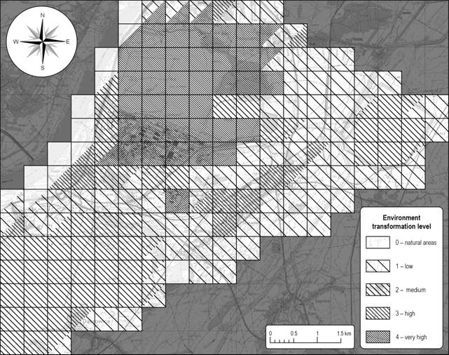
Fig. 4.
Environment anthropogenization level in the vicinity of “Machów” sulphur
mine.
Forms
possessed by reclamation activity lose its anthropogenic character because of
natural – mostly woodland and aquatic development. Similar situation concerns
agricultural development because such interference in natural environment is
incomparably lower than mining or processing industry development. Analysing
obtained results very strong transformation of former mine excavation is
noticeable (basic fields: 9–13, 17–22, 28–34, 42–45, 58–63, 75–79). It is
obvious with regard to triple change of area character and its function – from
settling–agricultural to industrial and then to water object with recreational
function. High and medium transformation level was signified on strictly
anthropogenic areas represented through infrastructural objects grounds
(squares: 114–115, 52–54, 68–70, 85–87, 129, 134–139, 145–150, 155–160, 162–164).
Former agricultural grounds which are representing big part of researched area
revealed low anthropogenization level. They haven’t change their image through
the decades and the only anthropogenic interference was made on soils by the
agrotechnical infuence. It is worth to be remarked that on the study area
appear also natural grounds (basic fields: 1, 16, 40, 56, 72, 88, 152). In
their limits the anthropogenic conversions were not ascertained. These habitats
are located in the neighbourhood of flood–plaines of Wisła river and
building forest–meadow natural habitats.
The
change of industry objects character will happen within next dozens of years
because of intensively provided reclamation works. Consequently the area
transformation level can decrease through the time. Therefore it can be
concluded that the area image and functionality will refer to primary stand. It
is hard to interchangeably affirmed how in the future will the infrastructure
network change. Probably the road network remain unaltered. The quantity of
other transfer networks can be reduced by lower energy and water absorptivity
of new development kinds. Presumably only the processing plant shut down will
permit on this area for significant restriction of technical infrastructure
quantity. Building industry in connection with expansion of recreational spaces
will develop certainly. Changes of structure and functions on the study area
will be strongly noticeable in the next few years.
CONCLUSIONS
1. For many years the explored area was exposed to
transformations developed from interference of human activity what was proved
by measured area transformation level. Many anthropogenic forms have emerged
here and their stand is permanent enough to stay visible and recognizable in
the landscape for a long time.
2. Changes connected with interaction of sulphur mining
and processing industry affected negatively on the shape of environment,
causing unfavorable structural changes and disorder of original landscape
harmony.
3. The determination of area transformation level let
capture which fragments of the surface still demonstrate anthropogenic
character and which can be recognized as seminatural thanks to adequately
conducted reclamation.
4. Reclamation activity gradually restores utilitarian
value to the degradated areas and in some places even the initial image of
landscape. It affected the woodland–agricultural development of former mine
infrastructure objects, for example external dumping ground and wastewater
tank.
5. In the area of mine the changes still take place. End
of reclamation works and implementation of final recreational function will let
define the full range of environment transitions that took place at the
described area.
REFERENCES
1.
Agger B. P., Ecological consequences of current land use
changes in Denmark and some perspectives for planning and management.
Proceedings of European Seminar on Practical Landscape Ecology, vol. 4, s.
93-107, Roskilde 1991.
2.
Bartkowski T., Ochrona
zasobów przyrody i zagospodarowanie środowiska geograficznego.
PWN, Warszawa- Poznań 1973.
3.
Chmielewski S., Zmiany
środowiska geograficznego w strefie oddziaływania wielkiego miasta na
przykładzie północno- wschodniej części
warszawskiego zespołu miejskiego. Dokumentacja Geograficzna 1/1980.
Wydawnictwo PAN, Zakład Narodowy im. Ossolińskich, Wrocław-
Warszawa- Kraków- Gdańsk 1980.
4.
Degórski M.,
[red.] Natural and human environment
of Poland.
A geographical overview. IGiPZ
PAN, PTG, Warsaw 2006.
5.
Fedorowicz J., Antropogeniczne
przeobrażenia środowiska geograficznego na terenie miasta Torunia.
Studia Societatis Scientiarum
Torunnesis,
Sectio C (Geographica et Geologia), vol. X, nr 3, Wydawnictwo UAM,
Toruń 1993.
6.
Fels E., Der wirtschaftende Mensch als Gestalter der Erde.
Frankh Verlag. Stuttgart 1954.
7.
Fels E., Die Umgestaltung der Erde durch den Menschen.
Schöningh Verlag. Paderborn 1969.
8.
Małecki Z., Oddziaływanie
przemysłu siarkowego na środowisko przyrodnicze i kierunki
ograniczenia tego zagrożenia. Przegląd Geologiczny, vol. 41, nr
2, s. 89-93, PIG, Warszawa 1993.
9.
Marsh G. P., Man and nature or physical geography as modified
by human action. A. Weyerhäuser environmental classic, University of
Washington Press / Chesham Combined Academic, Seattle- Washington 2003.
10.
Maruszczak H., Zmiany
środowiska przyrodniczego kraju w czasach historycznych. [w:] Starkel
L. [red.] Przemiany środowiska geograficznego Polski, s. 109-135,
Wydawnictwo PAN, Zakład Narodowy im. Ossolińskich, Wrocław 1988.
11. Niewiadomski A., Ekologiczne efekty rekultywacji
terenów dawnej kopalni siarki „Machów”. Materiały
Konferencji pt. Wkład młodych naukowców
w rozwój nauk rolniczych, Puławy 23-24 listopada 2007, s. 165-171.
IUNG, Puławy 2007.
12.
Niewiadomski A., Sorpcyjne
i buforowe właściwości gleb okolic zbiornika wodnego po kopalni
siarki w Machowie. Materiały I Ogólnopolskiej Konferencji
Geografów- doktorantów, Lublin 12-14 czerwca 2006, s. 79-84.
Wydawnictwo Akademickie, Lublin 2006.
13.
Papińska E., Wpływ
antropopresji na przemiany środowiska geograficznego województwa
łódzkiego (w granicach z lat 1975-1998). Acta Geographica
Lodziensia nr 81, ŁTN, Łódź 2002.
14.
Podgórski Z., Antropogeniczne
zmiany rzeźby terenu woj. toruńskiego. Studia Societatis Scientiarum Torunnesis, Sectio C (Geographica et
Geologia), vol. X, nr 4, Wydawnictwo UAM, Toruń 1996.
15.
Sherlock R.
L., Man’s influence on the Earth.
Home University library of modern knowledge, nr 154, T. Butterworth Limited. London
1931.
16.
Żmuda S., Antropogeniczne
przeobrażenia środowiska przyrodniczego konurbacji
górnośląskiej. PWN, Warszawa- Kraków 1973.
dr
Arkadiusz Niewiadomski, Department of Soil Science and Geoecology, University
of Łódź,
ul. Narutowicza 88, 90-139
Łódź, Poland.