Paweł Pędzich, Ph.D., Michał Stankiewicz Ph.D.

Institute of Cartography, Faculty of Geodesy and Cartography,

Warsaw University of Technology


The Topographic Database as the basis for development of topographic maps in Poland


Since the beginning of the seventies of the 20th century topographic maps were published separately for military and civilian purposes. Maps published for civilian use were developed at scales 1:10 000, 1:25 000 (until 1992) and 1:50 000. Since the middle of the nineties the 1:10 000 civilian topographic map has been developed in the new version, with respect to the content, as well as to graphics, which completely differ from the military maps. Those maps have been developed using digital technology.

Works concerning the idea of development of the Topographic Database with the level of details corresponding to 1:10 000 topographic maps, were commenced in 2000. After the technical guidelines were approved in 2003 the first development of the Topographic Database, including cartographic works at the scale of 1:10 000, was started for selected areas in Poland.

            Since the middle of the nineties the Military Geographic Services have been publishing topographic maps according to the NATO standards. Those maps, made at the scale of 1:50 000, are developed basing on the VMap Level 2 database (the 2nd level vector). Since 2003, the 1:50 000 topographic map in its civilian version, has been also developed using the VMap Level2 database.

Both,  the Topographic Database, and the VMap Level 2 database are the components of the Polish Spatial Data Infrastructure, which has been developed in Poland, and they are considered as reference databases for other databases and thematic works.


1. Development of the Polish Spatial Data Infrastructure

The Spatial Data Infrastructure is a set of legal, organisational, economic and technical means, which:

·        Ensure the common access to geo-information data and services, concerning the specified area,

·        Contribute to efficient utilisation of geo-information for the needs of sustainable development of that area,

·        Allow for rational administration of geo-information resources.


Depending on the area, the Spatial Data Infrastructure may be developed at the local (as for a city), district, regional (as for a province), national, international (e.g. European) or global levels.

The Spatial Data Infrastructure covers:

·        Systems and spatial databases, which contain data and metadata of appropriate content and quality, which are mutually related and able to co-operate,

·        Tele-information and geo-information technologies, which apply commonly acknowledged standards,

·        Legal regulations, organisational structures, economic solutions and human resources,

·        Users, who create the information society (Lexicon of the Polish Association for Spatial Information).     

Development of the Spatial Data Infrastructure in Poland has been based on rules specified in the INSPIRE Directive, adopted by the European Parliament in March 2007. This Directive specifies the “general rules aiming at establishment of the Spatial Data Infrastructure within the Community for the needs of the common environmental policy, as well as other policies or activities which may directly or indirectly influence the natural environment”.

The basic objective of development of the National Spatial Data Infrastructure (NSDI) is to facilitate the access to spatial information for citizens of a given country, as well as for public administration entities, business companies, universities etc.

In Poland this task is – among others - implemented by:

·        Development of reference topographic databases,

·        Development of meta databases,

·        Introduction of unique identifiers for geographic objects.

Within development of the Spatial Data Infrastructure the following reference databases have been created in Poland:

·        The General Geographic Database (BDO) (corresponding to the accuracy of 1:250 000 maps),

·        The VMap L2 database (corresponding to the accuracy of 1:50 000 maps),

·        The State Register of Borders,

·        The Topographic Database (corresponding to a 1:10 000 map).


2. Definition of the Topographic Database and its objectives

The Topographic Database (TBD) is the official name of the coherent system of data acquisition and distribution at the national level, which operates basing on appropriate legal regulations.

The objective of the TBD development is:

·        To perform functionality of delivery of updated topographic data,

·        To avoid multiple acquisition and updating of the same data by many users,

·        To ensure updated topographic data for topographic and thematic  map making systems.

Data contained in the TBD Database may be the starting point for development of spatial information systems for various governmental and local government institutions and they may be utilised by systems developed within the private sectors.


3. Mathematical foundation of the TBD

The topographic database is developed in the „1992” System, which is uniform for the entire area of Poland. The GRS 80 (Geodetic Reference System 1980) ellipsoid has been assumed as the reference surface.

Gauss-Krüger projection has been assumed in the „1992” System, in the meridional zone covering the entire area of Poland, (more than 10°), with the axial meridian L0 = 19° E, for which the length scale equals to 0.9993 (length deformation -70 cm per 1km). Similar deformations occur at the Eastern and Western edges of Poland. Lines of the null deformations are located within the distance of approximately 240 km from the axial meridian.

The origin of the rectangular co-ordinate system is the point of crossing of projection of the axial meridian 19° (X axis) with projection of the Equator (Y axis), providing that coordinates of this point are: X0 = -5300 km, Y0 = 500 km.

Such assumptions allow to develop spatially continuous Topographic Databases, without the necessity to divide them into projection zones.


4. Construction of the TBD

The Topographic Database consists of two main components: the basic resources and the cartographic resources.


4.1 The basic resources of the TBD

The basic resources is the TBD component, organised and recorded according to the general standards concerning development of spatial databases, which are assumed for geographic information systems, which contain measurement data, not distorted in result of editing works, connected with cartographic presentations and which are the result of primary data generalisation, resulting from measurement methods and assumed conceptual models of data.

The basic resources are composed of three main databases:

·        The integrated, spatially continuous vector topographic database (the so-called, TOPO component),

·        The digital terrain model database, recorded for particular map sheets (the NMT component),

·        The database of orthophotomaps, recorded for particular map sheets (the ORTOFOTO component).


4.1.1 The TOPO component

This is the spatially continuous, vector topographic database, developed basing on GIS technology. The vector topographic database is the foundation for cooperation of the Topographic Database with various spatial information systems. The Database is created basing on the vector data model, which is typical for GIS systems, in which geometrical properties of objects are recorded by means of ordered and mutually related coordinates. The vector topographic database is a “continuous” database with respect to spatial range of databases – division of data into map sheets does not exist. Spatial divisions results from organisational solution of the TBD only (e.g. division of competence concerning development and administration of the TBD in particular provinces).

The vector topographic database is administered and organised by means of GIS technology which allows for efficient searching and analysis of data, as well as for  individual or common cartographic presentation of the digital terrain model, digital orthophotomaps and vector data.

The geometric accuracy of representation of objects in the TOPO component first of all depends on possibilities of object interpretation on the orthophotomap and on the topographic map at the scale of 1:10 000. The total mean error of position of points which are well visible on the orthophotomap, should not exceed 5 m.


Data Model

In data modelling performed for the needs of the TBD the basic terms included in the OpenGIS Abstract Specification (OGC) are applied. The “simple object” model is used in the TBD, i.e. objects of geometric properties which are limited to simple geometric objects (a line, a segmented line, a polygon), for which coordinates are defined in two dimensions and description of a curve line is the subject of linear interpretation.

The basic assumption of a conceptual model:

·        Distinguishing, mainly basing on physiognomy of classes included in the land cover categories, in a way which allows to completely fill the space,

·        Regardless the land cover, consideration of functional entities (the group of „land use complexes”), such as industrial plants, harbours, breeding farms etc.,

·        Common existence of object classes, which correspond to various levels of generalisation, applied in conventional cartographic works,

·        Assumption of road pavement sections (instead of road sections) as the basic sections which represent the road network.


Classification of objects in the TBD

Following the general idea concerning the TDB development, its information content corresponds, in its basic part, to the information content of existing Polish civilian topographic maps. At the most general level, the following classes of objects are included in that information content:

·        Networks of water streams

·        Networks of roads and railways

·        Technical infrastructure networks

·        Geodetic and photogrammetric control networks

·        Structures and installations

·        Land use complexes

·        Protected areas

·        Administrative and land register divisions

·        Land cover complexes

·        Other objects.

The coding system

The system of object coding, connected with classification, aims at systematisation of particular objects and it is the basis for the database organisation.

Depending on the level, various levels of code development are assumed, which are visible in the database as the attribute X_KOD_TBD (using the example of a tram line):

·        Level I: SK (road and railway networks),

·        Level II: SK KL (tracks or sets of track),

·        Level III: SK KL 02 (track or set of tram tracks).


Fig. 4.1 Diagram of the TBD object coding


Database structure

Particular classes of objects have a set of obligatory attributes and a set of special attributes, assigned to those objects. Besides attributes, which are obligatory for the TBD, some additional attributes have been also considered, which may be used by the database users.

Special attributes are distinguished by adding „X_” characters at the beginning of the attribute name. Special attributes include: the object code, metadata and cartographic attributes.

X_KOD_TBD  – the full object code,

X_KOD_VMAP – the Map code, corresponding to the given object,

X_AKTUALNOSC_G, X_AKTUALNOSC_A – indicator of up-to-datedness of geometry and attributes of objects,

X_KAT_DOKL_GEOM – category of geometric accuracy,

X_DOKL_GEOM – the mean error of object position in meters,

X_ZRODLO_DANYCH_G, X_ZRODLO_DANYCH_A – source of geometric and attribute data,

X_KAT_ISTNIENIA – status of the object,

X_UWAGI – information concerning input of data,

X_UZYTKOWNIK – data which identifies the introduced object,

X_ID_SKR_KARTO – reference to the list of abbreviation of the 1:10 000 topographic map.


Sources of data

The basic sources of geometric data for the TBD database are: digital orthophotomaps, field reconnaissance, data from large-scale databases (the basic map, land register maps). The additional source of data are existing sheets of the topographic map at 1:10 000 scale, documents, which contain digital records of the topographic map of Poland, 1:10 000 scale (the so-called, skeleton version), drawing materials of names together with lists of names, drawing materials of spot heights etc. Data collected in the TBD Database may be the basis for development of spatial information systems.

All objects should be introduced according to their real field position, with maintenance of all required topological relations.

Besides, data for the TBD Database may be acquired from the following sources:

1)      Selected data from the GEOS Database (the Databank of Geodetic control networks) – CODGiK (the Geodetic and Cartographic Documentation centre),

2)      Selected data from the PRG Database (The State Register of Borders) – CODGiK,

3)      The Bank of Geographic Names – CODGiK,

4)      The Databank of Administration of Public Roads,

5)      The Databank of Water Management Offices,

6)      The Hydrographic Database of Poland,

7)      The VMap Level 2 Database,

8)      The list of identifiers and names of localities (GUS – The Main Statistical Office),

9)      The Central Catalogues of Streets (GUS),

10)  The 1:50 000 Topographic Map (civilian version),

11)  Forest maps.


4.1.2 The NMT component

The NMT component is the digital terrain model database recorded according to division into sections (single map sheets or sets of map sheets). The database is created in two forms, as measurement data and useful data. The digital terrain model is an important element of the “TBD resources”, with respect to external users of the TBD database, as well as for creation of digital orthophotomaps and development of topographic maps. The NMT database is created following orders for the development of the Topographic Database (TBD) or received to the “TBD resources” from other projects, if they meet quality criteria and technological requirements defined in The Technical Guidelines of the Topographic Database (TBD).


4.1.3 The ORTO component

The ORTO component is the database of digital orthophotomaps in sectional division (single map sheets). The basic form is the true-colour orthophotomap, recorded in RGB (three-layer) mode.

The ORTO component is created following orders for the development of the topographic Database (TBD) or received to the resources of the TBD orthophotomaps, made in other projects, which meet the quality criteria and technological requirements defined in The Technical Guidelines of the Topographic Database (TBD). The area module of the orthophotomap is an area described by means of the smallest rectangle of sides parallel to X,Y axes of the “1992” System, which contains the standard section of the Topographic Map of Poland at the scale of 1:10 000 (the so-called, MBR – Minimum Bounding Rectangle), enlarged by the margin of 250 m width. Within the area module and the entire block, for which orthophotomap modules are developed, the digital orthophotomap should be unified with respect to tones, colours and contrast and it should create the continuous images without improper visual effects.


4.2 Cartographic resources

Cartographic resources are the part of the TBD resources, organised in accordance with the cartographic data model and being the result of transformation of the basic resources. It serves for development of high quality cartographic presentations (in particular topographic maps), within the TBD as well as by external map making systems.

Creation of the digital cartographic resources (digital maps) aims at familiarisation of distribution of topographic data in the digital form to specialised map making systems, such as sozological, geological maps, as well as for external map making systems, including topographic maps. In its final version the TBD should allow for generating topographic maps in the entire series of their scales.


5. Metadata

Technical Guidelines of the Topographic Database assume that – regardless for the spatial coverage and type - for each newly created set of data, a metadata file should be created, which should be used for creation of a metainformation module in the Topographic Database Management System.

Metadata should be understood as data concerning objects or data sets, which create the resources of the TBD. They are collected for the needs of correct identification of data files and appropriate evaluation of data usefulness from the user’s point of view.

Metadata have limited relations with individual objects of the vector topographic database (TBD). Metadata cover the data of acquisition of an object, the up-to-datedness status, the last updating date, the identifier of an operator who introduced or updated the object, the source of geometric and descriptive data, the accuracy of geometric description (the accuracy class) and the way of the object representation.


6. Development of topographic maps using the TBD data

Development of topographic maps using the TBD data is based on the idea proposed by representatives of the, so-called, Hannover School, concerning separation of spatial databases from cartographic works. Following that idea two spatial data models are considered – the Digital Landscape Model – DLM, and the Digital Cartographic Model – DCM.

The DLM is the possibly accurate projection of the geographic space, assuming the certain level of generalisation. It is created by objects of real geometric properties, undisturbed by the map editing processes, which are recorded in the vector form. The Digital Landscape Model creates the TOPO and NMT components of the TBD Database.

The DCM is created out of the DLM in the cartographic editing process. It is assumed that the cartographic output of the TBD should allow to obtain two version of products at the scale of 1:10 000:

·        The topographic map in the TBD standard,

·        The topographic map, corresponding to the obligatory technical instruction of 1998.


The topographic map in the TBD standard is made considering the needs to plot  high quality printouts of small number of copies, following special orders. Such a map allows to meet information expectations of users and maintain the possible highest up-to-datedness of data and speed of production. It should be made in highly automated way, using the data from the database, with relatively small editing works, but with consideration of correct information presentation and cartographic quality. Graphical convention should be similar to the graphical convention defined by the obligatory technical instruction concerning the civilian, topographic map making.

      The topographic map in its version following the technical instruction, is made with respect to the needs of multi-copy printing. Such a map should be made basing on data from the basic resources of the TBD or basing on digital map files prepared according to the TBD standard. In both cases this would require additional processing and data amendments. Data prepared in such a way should allow for generation of transparencies for map printing.  (Technical Guidelines of the Topographic Database (TBD), 2003).


6.1 Differences between rules of editing topographic maps in the TBD standard and topographic maps corresponding to the obligatory technical instruction


Editing rules concerning topographic maps according to the TBD standard are slightly different than rules concerning topographic map making, resulting from the obligatory technical instruction.

Those differences results mainly from:

·        intention to maintain many objects in their real positions on the TBD standard map,

·        intention to limit various methods of geometric representation of the same classes of objects (e.g. buildings represented by means of area symbols only),

·        intention to introduce regular patterns and line styles (e.g. introduction of regular patterns – a symbol of forests),

·        renouncement from the existing, detailed presentation of some terrain elements (e.g. pavements),

·        necessity to  present data on the new quality (e.g. in case of two-roadway roads the necessity to present two axes instead of one axis of a roadway),

·        intention to construct symbols which allow to simplify generation from the database (renouncement from all “tentacles” in symbols, e.g. a symbol of a bridge or a shed).

Therefore topographic maps in the TBD standard are characterised by simplified graphics comparing to maps made according to the obligatory instruction. First of all, cartographic symbols have simplified forms, and repeatable patterns are applied. Less attention is paid to application of editing rules which concern symbol displacement, deletion of a part of a symbol or replacement of a part of a given symbol by another symbol.


Table. 6.1 Differences between selected symbols of topographic maps following the TBD standard and maps made according to the obligatory technical instruction

Symbol description

Topographic map in the TBD standard

Topographic map corresponding to the instruction

Administrative borders

Highway

Railway bridge

Deciduous forest

Coniferous forest


6.2 Stages of topographic maps development basing on the TBD vector data


The process of generation of topographic maps, following the TBD standard, may be divided into the following stages:

  1. selection of vector data from the TBD,
  2. generation of additional cartographic objects (as land use outlines),
  3. division into map sheets,
  4. generation of contours from the NMT,
  5. development of a map frame and marginal information,
  6. generation and editing of labels,
  7. development of graphics following the guidelines (library of symbols).


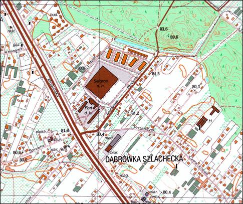
Fig. 6.1 Topographic map 1:10 000 following the TBD standard

In order to make the topographic map in accordance with the technical instruction, the following actions should be performed:

  1. additional generalisation (e.g. modification of representation of small buildings, from surface to point presentation),
  2. displacements, breaking of objects, e.g. sections of borders, buildings located close to roads, power supply lines in built-up areas,
  3. acquisition of additional data, e.g. edges of pavements,
  4. exchange of libraries of symbols, utilisation of irregular patterns (Gotlib 2003).


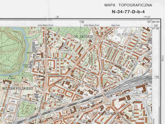
Fig. 6.2 Topographic map 1:10 000 made according to the obligatory technical instruction


Final remarks

The Topographic Database is a source of new generation of data comparing to the existing topographic maps. It is not only the basis for development of civilian topographic maps, but it is also the reference database for many thematic works. Together with the VmapL2 and BDO databases it is the basis for development of the infrastructure for spatial information in Poland. At present, works aiming at unification of conceptual models of those databases, in order to allow the direct data flow between them, are continued. Works concerning the simplified version of the Topographic Database for areas of lower economic importance, have been also commenced.

The Topographic Database is the foundation for modern systems of topographic map making, where the development of cartographic projection is highly automated. The TBD highly simplifies the process of topographic map making for the needs of multi-sheet printing. It also allows for generation of maps of simplified graphics, commissioned for selected areas. Together with the Topographic Database development, new possibilities of topographic data visualisation appeared, for example presentation in perspective projection, with orthophoto or digital terrain model background.


References

1. The General Surveyor of  Poland, 2003, Technical Guidelines, Topographic Database – version 1, the Head Office of Geodesy and Cartography.  Główny Geodeta Kraju, 2003, Wytyczne techniczne, Baza danych Topograficznych  wersja1, GUGiK,

2. The General Surveyor of  Poland,1998,  Rules of editing 1:10000 topographic maps, Patterns of symbols, Technical Instruction, the Head Office of Geodesy and Cartography. Główny Geodeta Kraju, 1998, Zasady redakcji mapy topograficznej w skali 1:10 000. Wzory znaków, Instrukcja techniczna, GUGiK,

3. Gotlib D., 2003, Topographic Database versus topographic map making, Archives of Photogrammetry, Cartography and Remote Sensing,  Baza Danych Topograficznych a produkcja map topograficznych, Archiwum Fotogrametrii, Kartografii i Teledetekcji, vol. 13a, pp. 69-75,

4. Lexicon of the Polish Association for Spatial Information,  Leksykon Polskiego Towarzystwa Informacji Przestrzennej, http://www.ptip.org.pl.