Warsaw University of Technology
Hydrographic and Sozological Database as a source of information on geographic environment in
Poland
One
of the tasks of the State Geodetic and Cartographic Services, which are
subordinated to the Head Office of Geodesy and Cartography, concerns production
of official thematic maps, including the Hydrographic Map of Poland at the
scale of 1:50 000 and the Sozological Map of Poland at the scale of 1:50 000.
Since 2005 those maps, which are accessible in both, digital and analogue
forms, have been made basing on the developed hydrographic and sozological
databases.
Whilst
“hydrography” is a universal and commonly known term, the term „sozology”,
which exists in the Polish science, geography and cartography, requires some
more explanation. This term originates from the Greek language in which the
word sozein means “to protect, to
safe”. It was firstly introduced in Poland in 1965 by Professor Walery Goetel
for the science related to protection of the nature and natural resources.
Practically, the scope of sozology, as the science, is much wider and it also
concerns research on investigations of natural transformations resulting from
antropopression and prevention against their negative impacts.
1. Hydrographic and
sozological maps – the historical approach
The
precursor of production of the hydrographic
map in Poland was Professor M. Klimaszewski, who proposed – at the
beginning of the fifties of the 20th century - to make and publish
the hydrographic map of Poland basing on field surveys. In the period 1954 – 64
four successive issues of instructions concerning the development of the
hydrographic map of Poland at the scale of 1:50 000 were published under the
auspices of the Institute of Geography of the Polish Academy of Science. Basing
on those instructions, 45 map sheets were made and printed in the period 1958 –
69. Further works concerning the development of that map were discontinued in
1968.
In
1980 the Head Office of Geodesy and Cartography initiated efforts concerning
the re-development and publication of the hydrographic map of Poland. In the
period 1983 – 85 several successive versions of instructions and selected map
sheets were elaborated. After the final version of the instruction was
approved, the hydrographic map of Poland at the scale of 1:50 000 was made
after 1986 as the analogue product.
In
1996 the content of the hydrographic map was the subject of a questionnaire,
which was filled by interested institutions and organisations. Experiences
gained in the course of making hydrographic maps of high diversification of
water conditions and phenomena, as well as the access to information techniques,
resulted in 1997 in development of modified Technical Guidelines K-3.4 “The
Hydrographic Map of Poland at the scale of 1:50 000” with consideration of a
new, digital form of the map. The main technological changes were related to
formal regulations concerning rules of map making, preparation of
transparencies in the digital form and application of the triad printing
technology (Karpińska, 2005).
In
the period 2002 – 2004 technical guidelines were modified again. Changes
introduced in that period referred both, to the substantial and technological
parts of the map making process, as well as the name of the Guidelines. Due to
the particular attention paid to development of thematic database, the name was
changed into “The GIS Technical Guidelines – 3, The Hydrographic Map of Poland,
1:50 000 scale, in the analogue and digital forms” (the final version in 2005).
Map
sheets have been made and published following the new GIS-3 Guidelines since
2004. It is estimated that currently about 50% of Poland is covered by the
Hydrographic Map of Poland at the scale of 1:50 000.
The
first sozological maps in Poland,
made at various scales, first of all within the Małopolska region, as
cartographic approach of sozological research works, were made as early as the
beginning of the seventies of the 20th century. Preparation and
publication of the sozological map of the then existing Leszno Province, at the
scale of 1:100 000, in the middle of the eighties, was of crucial importance.
Authors of that map proposed to make regional sozological maps at the scale of
1:200 000. As a result of discussions performed during scientific conferences
the idea to make and publish the Sozological Map of Poland at the scale of 1:50
000 was approved.
In
1987 the outline of technical guidelines, which – together with a model map
sheet – was distributed among scientific reviewers, as well as among
institutions and voivodship (provincial) offices. In 1990 the final version of
the guidelines was approved, as “The Technical Guidelines K-3.6 Sozological Map
of Poland at the scale of 1: 50 000”. In 1996 the sozological map content
was the subject of a questionnaire, the aim of which was to collect opinions
concerning its usefulness and to gather conclusions and proposals related to
its possible improvements.
Experiences
gained in the course of development of sozological maps of various areas, as
well as the access to information techniques, resulted in 1997 in development
of modified Technical Guidelines with consideration of a new, digital form of
the map. The main technological changes were related to formal regulations
concerning rules of map making, preparation of transparencies in the digital
form and application of the triad printing technology (Karpińska, 2005).
In
2002 works concerning the new modification of the Guidelines were started.
Changes introduced in that period referred both, to the substantial and
technological parts of the map making process, as well as the name of the
Guidelines. Due to the particular attention paid to development of thematic
database, the name was changed into “The GIS Technical Guidelines – 4, The
Sozological Map of Poland, 1:50 000 scale, in the analogue and digital forms”
(the final version in 2005).
Map
sheets have been made and published following the new GIS-4 Guidelines since
2004. It is estimated that currently about 50% of Poland is covered by the
Sozological Map of Poland at the scale of 1:50 000.
Substantial
modifications introduced into technical guidelines of the hydrographic and the
sozological maps resulted mainly from harmonisation of the Polish law with
the European Union standards. Patterns of conventional symbols, used for those
maps, were also modified.
Technological
modifications concerned:
-
modification
and development of the structure of thematic layers,
-
introduction
of a term „cartographic imagery” as a vector representation of an analogue map,
-
utilisation
of the VMAP Level2 database as the reference topographic database,
-
development
of a unified quality control system for data transferred to the data resources,
-
development
of software tools, which support the map making process,
-
reorganisation
of rules concerning development of external databases (TERYT, REGON),
-
maintenance
of technological continuity with the existing version of the Guidelines, by
means of automation of the process of archive data conversion to the new
structure of thematic layers (www.gugik.gov.pl).
2. Thematic Database
2.1. Hydrographic Database
The Hydrographic
Database is a thematic spatial database, which synthetically presents water
circulation conditions in relation to the natural environment, the level of
investments and transformations of the environment. It is developed basing on
the reference database, into which results of field mapping of phenomena and
water structures, as well as soil permeability and numerous information related
to management of water resources, water quality evaluation and the hydrosphere
network monitoring results are overlaid.
The Hydrographic
Database is maintained in the GIS technology in MapInfo Professional
environment. The VMAP Level2 database, of the geometric accuracy which
corresponds to 1:50 000 scale maps, is used as the reference topographic
database, to which layers of the Hydrographic Map are referenced. The Spatial
Database is an important component of the Hydrographic Map, allowing to perform
complex spatial analyses.
The Hydrographic Database is not the
product of research works only, which aim at registration of phenomena and
water or water-and-economic structures. It also contains study materials to be
used in the course of research works in the field of the natural environmental
sciences. The importance of this maps grows in the conditions of growing
degradation of the environment. It is addressed to offices and institutions
dealing with water-and-economic issues, physical planning, as well as
management and protection of the natural environment.
The hydrographic database is useful
for the needs of solution of such social-and-economic tasks, as: water supply,
designing locations of new settlements, as well as industrial investments,
investments in the water power engineering and water melioration sectors, flood
protection, prevention against flood impacts and for other issues related to
water management (www.gugik.gov.pl).
2.1. Sozological Database
The Sozological Database is a
thematic spatial database, which presents the conditions of the natural
environment as well as reasons and effects of – negative and positive – changes
which occur in the environment as a result of various processes, including –
first of all – man-made activities; it also presents the ways how to protect
natural values of the environment. The database is mainly addressed to
institutions and offices dealing with the environmental protection issues and
to decision makers and planners at regional, province (voivodship), district
and municipal levels.
The
Sozological Database is maintained in the GIS technology in MapInfo
Professional environment. The VMAP Level2 database, of the geometric accuracy
which corresponds to 1:50 000 scale maps is used as the reference topographic
database, to which layers of the Sozological Map are referenced. The Spatial Database
is an important component of the Sozological Map, allowing to perform complex
spatial analyses.
The
sozological database is useful as the source of information on the level of
pollution, environmental hazards, as well as the tool for investigations and
determination of the natural conditions with respect to qualitative,
systematising and forecasting aspects. It may be used for determination of the
synthetic index of the natural environmental conditions of various spatial
units; the digital version of this database allows to acquire, store and
visualise geographic data with permanent updating of the database (www.gugik.gov.pl).
3. Hydrographic Map of Poland, 1:50 000 scale
Map sheets of the Hydrographic Map
of Poland at the scale of 1:50 000 are made and published in the digital and
analogue forms, in the “1992” co-ordinate system, basing on the Hydrographic
Database. Therefore it is useful for solutions of the same social-and-economic
issues as the Database. Besides, this map creates the study material for
specified research works concerning the natural environment; it is the document
used for registration of changes of hydrological processes, which corresponds
to topographic maps at the same scale. This map is also the source cartographic
product for making hydrographic maps at smaller scales and for making related
thematic maps.
The thematic content of the map
consists of the following groups of elements, ordered according to several
information levels:
- topographic
watersheds,
- surface waters,
- groundwater
outflows,
- underground waters
of the 1st level,
- soil permeability,
- phenomena and
structures related to water management,
- hydrometric points
of stationary measurements.
Each of the above elements is
represented by the group of water phenomena and structures, presented by
conventional symbols on a map.
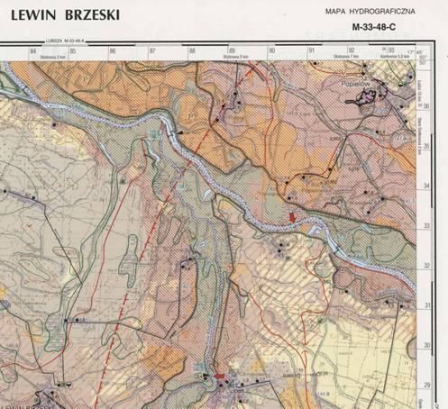
Fig. 1 Hydrographic Map of Poland, 1:50 000
scale
Comments are prepared for each map
sheets, which are placed on the reverse side of the map; those comments contain
important information concerning water circulation, as well as features of
surface and groundwaters within the area covered by the particular map
sheet. The comments are prepared by the
scientific consultant of the given map sheet.
Comments contain the characteristics
of the following elements:
- natural conditions
of the area,
- geological and
lithological structures,
- topographic
watersheds,
- rainfalls,
- surface waters,
- hydrological
conditions,
- groundwaters,
- hydro-climatic
conditions in the course of hydrographic surveys,
- surface water
pollution levels,
- transformation of
water conditions,
-
other information important for evaluation of hydrological conditions of the
selected area (GIS – 3 Technical
Guidelines).
4. Sozological Map of Poland, 1:50 000 scale
Map sheets of the Sozological Map of
Poland at the scale of 1:50 000 are made and published in the digital and
analogue forms, in the “1992” co-ordinate system, basing on the Sozological
Database. Therefore it is useful for solutions of the same social-and-economic
issues as the Database. The sozological map
is particularly useful in physical planning activities for locating new
industrial and municipal objects (including dwelling houses) as well as
recreation centres etc.
This map, made at the
scale of 1:50 000, is also the source cartographic product for making
sozological maps at smaller scales and for making related thematic maps.
The
thematic content of the map consists of the following groups of elements,
ordered according to several information levels:
- forms of protection
of the natural environment,
- degradation of
components of the natural environment,
- counteractions
against degradation of the natural environment,
- re-cultivation of
the natural environment,
- wastelands,
- auxiliary symbols
and markings.
Each of the above elements is
represented by the group of water phenomena and objects presented by means of
conventional symbols on the map.
Comments are prepared for each map
sheets, which are placed on the reverse side of the map; those comments contain
important information in the form of tables, diagrams and descriptions which
simplify the perception and amends the map content. The comments are prepared
by the scientific consultant of the given map sheet.
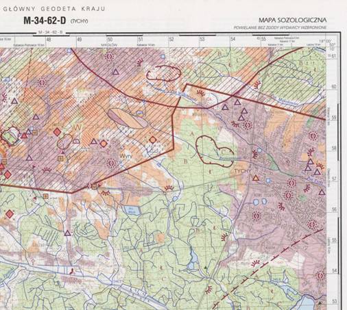
Fig.2 Sozological Map of Poland, 1:50 000 scale
Comments contain:
-
characteristics of the basic components of the natural environment and their
selected features, according to the following sub-sections:
physical-and-geographical locations, geological structure, terrain relief,
geo-morphology, surface waters, groundwaters, soils, vegetation cover, fauna,
climate,
-
wider information for particular information levels of the map, according
information levels, specified in the map content (text, tables, additional
maps),
-
general characteristics of the natural environmental conditions and levels of
their degradation,
-
guidelines concerning management and protection of the environment,
-
other important information and results of evaluation, e.g. wind rose,
information on location of natural resources, data concerning the subject of
control in monitoring sites and address information of those sites (GIS – 4 Technical Guidelines).
5. Hydrographic and Sozological Maps in a
digital form
Maps in the digital form are
characterised by the following features:
- the multi-layer
structure,
- each layer contains
vector objects from a selected thematic range,
- a descriptive part
is assigned to each layer – it is the database of a specified structure,
-
databases combined with particular vector objects, which characterise those
data with respect to quantitative and qualitative features,
-
compatibility of particular map sheets with the analogue map,
-
the possibility to combine adjacent map sheets in bigger vector objects (e.g.
provinces, districts and municipalities). This requires the settlement of
object identifiers in particular thematic layers. (www.gugik.gov.pl).
Final remarks
The Hydrographic and Sozological
Databases and maps generated from those databases at the scale of 1:50 000
contain a lot of information which originates from numerous sources, such as:
field surveys, photointerpretation of aerial and satellite images, as well as
from research works in the field of hydrography, ecology and environmental
protection. Information contained in those databases presents the complex
conditions of the geographic environment in Poland. Those works are used for
the needs of research works, for analyses related to physical planning,
designing of new investments etc.
Information included
in those databases quickly becomes out-of-date, therefore some information does
not always correspond to the reality. The best solution would be to develop a
system allowing for permanent updating of the database content. Due to mutual
covering of some information in both databases, works concerning the idea of
creating one, uniform database on conditions of the geographic environment,
have been continued. Such a database would cover the thematic content of the
Hydrographic and Sozological Databases, enriched by other issues related to
management of the geographic environment.
References
1.
The General Surveyor of Poland, 2005 – “The
GIS Technical Guidelines – 3, The Hydrographic Map of Poland, 1:50 000 scale in
the analogue and digital forms”., The Head Office of Geodesy and
Cartography (GUGiK), Główny Geodeta Kraju, 2005 – Wytyczne techniczne GIS – 3, Mapa
Hydrograficzna Polski skala 1:50 000 w formie analogowej i numerycznej, Główny
Urząd Geodezji i Kartografii, Warszawa,
2.
The General Surveyor of Poland, 2005 – The
GIS Technical Guidelines – 4, The Sozological Map of Poland, 1:50 000 scale in
the analogue and digital forms, The Head Office of Geodesy and Cartography
(GUGiK), Główny Geodeta Kraju, 2005 – Wytyczne techniczne GIS – 4, Mapa Sozologiczna Polski skala 1:50 000 w
formie analogowej i numerycznej, Główny Urząd Geodezji i
Kartografii, Warszawa,
3. Karpińska J., 2005 – Poland at various scales, in: 60th
Anniversary of the Head Office of Geodesy and Cartography (GUGiK), Polska w różnych skalach, w:
60 lat Głównego Urzędu Geodezji i Kartografii, GUGiK,
Warszawa.
4. www.gugik.gov.pl – the Head Office of
Geodesy and Cartography, Główny Urząd Geodezji i Kartografii.