Anna Majchrowska, Elżbieta Papińska
Lodz University
The South African landscape diversity and its protection
The Republic of South Africa occupies over 1,2 mln km2 at the southern tip of the African continent, stretching from 22°S to 35°S and from 17°E to 33°E. Due to a considerable variety of geology, relief, climatic conditions including oceanic influences as well as of vegetation and wild animals the country features a great diversity of landscapes.
Based on distinct environmental conditions and related sets of plant and animal life, South Africa can be divided into 9 biomes or major habitats, namely Albany thicket, desert, forest, fynbos, grassland, Nama karoo, savanna, succulent karoo, and wetlands (NBSAP, 2005). According to the biogeographic regionalisation of our planet developed within the framework of the World Wildlife Fund’s Conservation Science Program, South Africa falls within 17 terrestrial ecoregions (Olsson et al., 2001).
Fig.1. Location of the studied protected areas (according to www.sanparks.org)
South Africa’s conservation efforts for the diversity of landscapes and wildlife have included the expansion of protected area network. Based on field study carried out in 2005, the paper presents six protected areas exemplifying various ecoregions and biomes in the country.
Kruger National Park
Geographical location. Kruger National Park is situated in the north-east corner of South Africa, near the border with Zimbabwe and Mozambique (fig.1). It occupies the area between the Limpopo River in the north and Crocodile River in the south. The Park extends about 360 km from north to south and 60 km from west to east and covers nearly 20000 km2, what makes it the biggest national park in South Africa.
It is also one of the oldest protected areas in Africa, as the Sabie Game Reserve (in the south of contemporary KNP) was established in 1898. In 1926 a huge conservation area Kruger NP was established to protect the wildlife of the South African Lowveld. Now Kruger NP is a part of the Great Limpopo Transfrontier Park, and of UNESCO MAB Reserve named the Kruger to Canyons Biosphere Reserve.
Abiotic features. The Kruger NP is generally flat to undulating, with average height of 260 m above sea level. The Lebombo Mountains form the eastern boundary, and hilly areas occur in the south-west and far north. The highest level is about 2050 m above see level in the Drakensberg (Great) Escarpment where the plateau basin begins. Rocky outcrops also occur sporadically throughout the area.
In the area old metamorphic and magmatic rocks predominate, for example: diabase, rhyolite, granite, gneiss, different kinds of basalts and andesite. Younger alluvial deposits are found in river valleys (Venter, 1990).
Six major rivers traverse the park from west to east and this yield a range of riverine habitats, including forest. Cliffs and gorges occur where the rivers cut through the Lebombo Mountains, and also along the Luvuvu River in the north.
The geology and topography of the area have a decisive impact on climate, especially on the rainfall. Rainfall occurs in summer from September to March, decreasing from 800 mm in the south to 400 mm in the north, with an average of 500 mm. The temperature in the summer months is very high, routinely exceeding 31°C. The coolest months are June and July with the average minima and maxima of 9°C and 24,7°C respectively. The annual average maximum temperature is around 29°C; the annual average minimum is just less than 16°C.
Ecozones. The park’s wide variety of habitats can be summarised in 16 major habitat types (ecozones), which are the product of abiotic features (Jacana, 2000). For example, the younger surface of dark brown loam developed on basalt is the basis of Knob Thorn/Marula Savannah and Tree Mopane Savannah, whereas the older exposed surfaces have more sandy soils derived from granite and yield woodlands dominated by the Combretum species of leadwood and bushwillows. The vegetation types impact in turn the animal species that inhabit each of the ecozones.
Flat basaltic plains in the east support open grassland and savanna, while the undulating granitic soils in the west support various woodlands. In the drier area north of the Olifants River, Mopane is the dominant woodland and savanna tree, while in the moister south, mixed broad-leaved and acacia species occur.
In the far north, dense mixed woodland occurs on red sandy hills around Punda Maria, and a rugged dry Baobab and Mopane veld occurs around Pafuri. On the eastern boundary to the east of Punda Maria, the extensive Nwambiya Sandveld in Mozambique just pushes into the park with its characteristic sandveld vegetation and associated avaifauna.
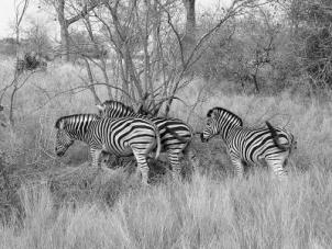
Biomes. The Kruger NP is situated in the savanna biome (fot.1). Savanna is the largest biome in southern Africa, occupying 46% of its area (Low, Rebelo, 1996). It is characterised by a grassy ground layer and a distinct upper layer of woody plants. Where this upper layer is near the ground the vegetation may be referred to as shrubveld, where it is dense as woodland, and the intermediate stages are locally known as bushveld. The shrub-tree layer may vary from 1 to 20 m in height, but in bushveld typically varies from 3 to 7 m. The shrub-tree element may come to dominate the vegetation in areas which are being overgrazed.
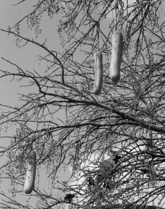
Flora and Fauna. The Kruger NP is home to an astonishing variety of flora and fauna species. Altogether it has 1982 species of plants. There are 336 tree species in the park, and the most typical include: Baobab, Marula, Mopane, Transvaal Mustard Tree, Sausage Tree (fot.2), Tamboti and Round-leafed Teak.
|
Fot.1. Savanna landscape with Burchell’s zebras |
|
|
Fot.2. Sausage Tree (E. Papińska, 2005) |
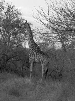
The most well-know mammal species (tab.1) in Kruger NP are: buffalo, elephant, giraffe (fot.3), impala, kudu, warthog, waterbuck, white rhino, wildebeest, cheetah, hyena, leopard, lion, wild dog, hippopotamus. Out of the 517 species of birds found at Kruger NP 253 are residents, 117 non-breeding migrants, and 147 nomads. There is very high endemism noted amongst the reptiles in the Kruger NP. In the park great venomous snakes of southern Africa are found, such as the Black Mamba and puff adder, and the African Rock Python.
Table. 1 Biodiversity in Kruger National Park
|
Species |
Number
in the Lowveld (and in KNP) |
% of
Southern African Species |
% of
African Species |
|
Birds |
520 (517) |
72% |
31% |
|
Reptiles |
118 (114) |
41% |
12% |
|
Amphibians |
35 (34) |
40% |
6% |
|
Fish |
53 (47) |
18% |
2% |
|
Mammals |
148 (147) |
64% |
18% |
www.kruger2canyons.com/bioregion.htm
The region is positioned to contribute uniquely to the conservation of South Africa's landscapes because of the atypical interfaces between the ecosystems associated with the escarpment and the savanna. The rapid change in the altitude of the land has created some unique niche habitats, each with their own endemic species.
Golden Gate Highlands National Park
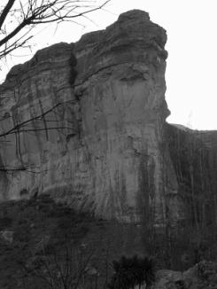
Geographical location. Golden Gate Highlands NP is situated in the north-eastern Free State near the Lesotho’s border. Golden Gate Highlands NP was proclaimed in 1963, to preserve the scenic beauty of the area of 42,9 km2. In 2007 QwaQwa National Park was incorporated into Golden Gate Highlands NP, and the size of protected area increased to 340 km2 (fig.1). The name ‘Golden Gate’ originates from the two cliffs that face each other on either side of the road: at sunset, the yellow sandstone becomes a rich gold colour (Fot.4).
|
Fot.3. Giraffe in Kruger NP (fot. E. Papińska 2005) |
Fot.4. “Golden Gate” (fot. E. Papińska 2005) |
Abiotic features. Golden Gate Highlands NP is situated in the Rooiberg Mountain Range in the foothills of the Maluti Mountains. Within the park, there is an altitude difference of some 1140 m between the lowest point in the Little Caledon river valley (1700 m) and the highest peak, Ribbokkop (2840 m). The eastern part of the Park is characterised by deep valleys with dense vegetation. The major feature is QwaQwa Mountain, an isolated range near the south-east border of the QwaQwa NP.
The geology of the park provides visual “textbook” with examples of Southern Africa's geological history. The Park is underlain by rock formations representing the upper part of the Karoo Sequence which is interrupted by dolerite dykes and sills. Recent alluvium and scree covers the valley floors while scree also covers the mountain slopes (Park Management Plan, 2006).
Located in the eastern highveld region, the Golden Gate Highlands NP experiences a dry and sunny climate during the winter period June to August. Average daily winter temperatures vary from a maximum of 16°C during the day to a minimum of -2°C at night, sometimes dropping as low as -9°C to -15°C, with frequent snow falls. The summers are mild, often with thunderstorms in the afternoon. Average daily summer temperatures from October to April vary from 27°C during the day to 13°C at night. The Park primarily falls in the summer rainfall area and the annual rainfall is approximately 760 mm. In very wet years this figure can rise to 1250mm.
Golden Gate Highlands NP is situated on the watershed between the Vaal and the Orange River systems, contributing quantity and quality water to the Gauteng region and into the Orange River system. As such, the park forms part of the most important water catchment in Southern Africa, namely the Maloti Drakensberg Catchment Complex. More than 50% of the total water supply of Southern Africa is produced by this catchment complex.
Biomes. The grassland biome is found chiefly on the high central plateau of South Africa, and the inland areas of KwaZuluNatal and the Eastern Cape. The topography is mainly flat and rolling, but includes the escarpment itself. Altitude varies from near sea level to 2850 m. Grasslands are dominated by a single layer of grasses (Moffett 1997). The amount of cover depends on rainfall and the degree of grazing. Trees are absent, except in a few localised habitats. Geophytes are often abundant. Frosts, fire and grazing maintain the grass dominance and prevent the establishment of trees.
The grassland biome is considered to have an extremely high biodiversity, second only to the fynbos biome. Golden Gate Highlands NP is the only grassland National Park in South Africa. The park contains over 60 species of grasses. The high rainfall in the area means that the soil is acidic and the grassland is termed ‘sourveld’. In summer, much of the grass takes on a reddish tint due to the Red grass that grows here. Red grass indicates excellent grazing and good condition of grassland.
Flora and fauna. The largest plant families in the park are the Poaceae (55 genera) as well as the Asteraceae (51 genera). The Afromontane forests are restricted to the ravines and gorges where moisture level is maintained and the vegetation is protected from fire. The valleys and the south-eastern aspects of the slopes are dominated by Leucosidea sericea or mixed Leucosidea sericea – Buddleja salviifolia woodland. Isolated patches of Protea woodland also occur.
Instead of reintroducing one of the "Big Five" into the park, the sungazer lizard and water mongoose were reintroduced. Twelve species of mice, 10 species of carnivores and 8 antelope species have been recorded in the park. The grey rhebuck and mountain reedbuck were present when the park was established. Eland, blesbok, black wildebeest, springbok, oribi and Burchell's zebra were also introduced.
The park supports at least 188 bird species, including the rare Bearded Vulture and the endangered Cape Vulture and Bald Ibis (BirdLife International, 2007). Once a common species in the Free State, Cape Vulture has declined dramatically since the 19th century. Desertion of the colonies at Thaba Nchu and Zastron are evidence of its contraction in distribution, which has been attributed to widespread poisonings by small-stock farmers attempting to poison mammalian predators such as caracals and jackals
iSimangaliso Wetland Park
Geographical location. iSimangaliso Wetland Park is situated on the east coast. in the KwaZulu Natal Province. It extends from the Mozambican border for more than 220 km southwards. The width of the land portion varies from 1 km to 24 km. The park also comprises a marine reserve of 5 km wide, stretching 155 km along the coast. The park was previously known as the Greater Saint Lucia Wetland Park, but was renamed on 1 November 2007. The word ‘isimangaliso’ is Zulu for ‘a marvel’ (World Heritage Site). The iSimangaliso Wetland Park is one of South’s Africa World Heritage Sites, and includes four sites designated under the Ramsar Convention as wetlands of international importance.
Abiotic features. The area has tropical and subtropical climate with warm, moist summers and mild dry winters. The mean annual temperature exceeds 21°C. The Agulhas current warms the coast. Rainfall in the park is temporally and spatially highly variable. At the coast it varies from 1200 to 1300 mm per year and decreases inland. About 60% of the rain falls in summer (Natural site datasheet from WCMC).
Ecosytems. The Park contains five interlinking ecosystems: 1) a marine system, characterised by the warm Indian Ocean, the continent's southernmost coral reefs, submarine canyons, and long sandy beaches; 2) a coastal dune system consisting of high linear dunes, sub-tropical forests, grassy plains and wetlands; 3) lake systems including two estuary-linked lakes, and four large freshwater lakes; 4) the Mkhuze and Umfolozi swamps, with swamp forests, extensive reeds and papyrus swamps; 5) an inland system which includes ancient shoreline terraces and dry savannah woodlands.
|
Fot.5. Nile crocodiles (Fot. A. Majchrowska 2005) |
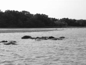
Fot.6. Hippopotamus (Fot. A. Majchrowska 2005) |
Flora and fauna. The Park is at southernmost end of the Maputaland Centre of Endemism and supports an exceptional ecological and biological diversity, especially of wetlands. The flora is diverse, having 152 families, 734 genera and 2173 species. In the Maputaland Centre of Endemism at least 168 species and subspecies are regarded as endemic or near-endemic. Of these, 44 are found in the Park.
There are 97 species of terrestrial mammals in the Park including the internationally threatened black rhinoceros, and 150 white rhinoceros. The Park has the largest single populations in South Africa of hippopotamus (about 700) (fot.6), red duiker and southern reedbuck. The Park also contains populations of five species endemic to South Africa: Hottentot golden mole, hairy slitfaced bat, Natal red hare, Tonga red squirrel and red duiker. All 32 marine mammal species are internationally threatened. Populations of bottlenose, humpback and spinner dolphins live in Park waters.
The herpetofauna is rich: 50 amphibians and 109 reptiles. The Park is the main South African breeding ground for loggerhead and leatherback turtles, with estimated populations of 2500 and 750 females respectively. The population of Nile crocodiles (fot.5) of approximately 1500 animals over 2 m long is one of the largest in Africa. The park is also famous as a home to coelacanth.
The very diverse avifauna numbers 521 species which is 60% of the South African total, approximately 200 of which are water birds for which the Park is an important refuge. The 339 breeding species include 23 of the 97 migrant species. There are four species endemic to South Africa and 47 endemic or nearly endemic to the region (Natural site datasheet from WCMC)
Tsitsikamma National Park
Geographical location. A large part of the African indigenous forest is protected in the Tsitsikamma NP, stretching for 80 km along the Indian Ocean coast. The Tsitskamma NP not only protects pristine forests but also marine life as it incorporates a marine belt stretching 5,5 km into the ocean. The park extends 3-4 km inland, generally following the 200-m contour. The park is situated between the coast and the Tsitsikamma Mountains, a part of the Cape Folded Mountains. The Tsitsikamma region takes its name from the Khoikhoi word meaning “place of much water”.
Abiotic features. The coastal plain, the cliffs dropping into the ocean, and the deep narrow valleys cut by six different rivers flowing down from the Tsitsikamma mountains are the dominant topographical features of the park.
Rain falls throughout the year in the region and annual precipitation sum generally increases from 500 mm along the drier coast to about 1500 mm in the wetter Cape Folded Mountains. The temperature varies from an average daily minimum of 7,4oC in July to an average maximum of 24,5oC in January (The Knysna and Tsitsikamma Forests, 2002).
The soils of these forests are mainly derived from bedrock of quartzitic sand-stone, typical of the early Palaeozoic Cape Supergroup of the Cape Fold Belt. The soils are generally acidic and poor in nutrients, partly due to washing out of nutrients by the high rainfall.
Biome. Natural forests are rare in a semi-arid country like the Republic of South Africa, since rainfall appears to be the primary environmentally limiting factor of forest extent. Forest is South Africa’s smallest biome and covers approximately 5300 km2 or merely 0,45% of the land surface (NBSAP, 2005). Forests are restricted to areas with mean annual rainfall of more than 525 mm in the winter rainfall region and more than 725 mm rainfall in the summer rainfall region (Forest Biome).
Flora and fauna. Local differences in climate, soil type and depth generate a variety of species and forest form in the park. Dry scrub-forest types are found in the dry coastal zone. Moist forest types with canopies up to 30 metres high and valuable timber trees occupy the higher coastal platform and hills. Wet forest types with dense undergrowth extend into the mountains and moist ravines.
The flora of the forests includes almost 90 tree species and 55 woody shrub species, in majority with evergreen foliage. Among the more common trees are the ironwood, stinkwood, Outeniqua yellowwood, real yellowwood, Cape holly, white pear, Cape beech, bastard saffron. About 280 herbaceous plant species occur in the forests, including 52 fern species, 25 grasses and a variety of flowering plants (The Knysna and Tsitsikamma Forests, 2002).
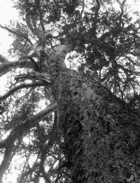
During the 18th and 19th centuries the Tsitsikamma forests were intensely exploited for valuable timber of stinkwood and Outeniqua yellowwood. As the result, today old giant trees are scarce. One of the largest trees is a huge yellowwood that towers 36,6m high, is estimated to be 800 years old and has a canopy spreading more than 30m wide (Fot. 7).
The Tsistikamma NP is home to about 50 mammal species (www.sanparks.org), including 5 species listed in the South African Red Data Book. These are the tree hyrax, samango monkey, blue duiker, giant golden mole and honey badger. One small mammal is largely confined to this region, is the long-tailed forest shrew (Knysna-Amatole montane forests ). However, the forest has a long history of human inhabitation and utilisation , which mean that large mammal populations, including buffalo, elephant, and possibly the leopard, have largely been destroyed.
At least 280 bird species have been recorded in the Tsitsikamma NP. Among the birds, the Knysna lourie, Knysna warbler, Knysna woodpecker, chorister robin-chat and forest canary are all near-endemic to this region (BirdLife International, 2007).
These forests are also home to the strictly endemic Knysna dwarf chameleon. The distributions of a number of amphibians are also centred around the forests in the region, and 3 species are regarded as strictly endemic.
|
Fot.7. “Big Tree” in Tsitsikamma (Fot. E. Papińska 2005) |
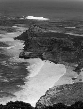
Fot. 8. Cape of Good Hope (Fot. E. Papińska 2005) |
Most plant and animal species of these forests are common and widespread. This helps ensure that they are well represented in formal conservation areas (Knysna-Amatole montane forests).
Table Mountain National Park
Geographical location. Table Mountain National Park, previously known as the Cape Peninsula National Park, was proclaimed in 1998 for the purpose of protecting the natural environment of the Table Mountain ridge, and in particular the rare fynbos vegetation. The park is situated south of Cape Town, on the Cape Peninsula, the south-western extremity of Africa. It stretches from Signal Hill in the north to Cape Point and the Cape of Good Hope in the south (fot.8). The area covers approximately 290 km2. The adjacent marine and coastal environments have been declared as marine protected area (TMNP Management Plan, 2006). In June 2004 the Cape Floristic Region, which includes Table Mountain NP, was inscribed as a Natural World Heritage Site (www.sanparks.org).
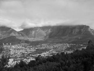
Abiotic features. The Cape Peninsula forms part of the Cape Folded Belt which are erosion-resistant, quartzitic sandstone mountains alternating with plains and valleys underlain by softer shales, and mantled at the coastal margin with young silicaceous and calcareous sediments. The topography is dominated by the sandstone plateaux and ridges which reach a maximum altitude of 1085 m on Table Mountain (fot.9).
The Cape Peninsula experiences Mediterranean-type climate, characterised by cool, wet winters and warm, dry summers. The rainfall recorded in different parts of the Peninsula shows remarkable variation for so small an area (400-2270 mm/year). Rainfall gradients are exceptionally steep. Up to 25% of the Peninsula's rain falls in the summer months.
Spatial and temporal variations in temperature are not pronounced and mean annual temperature is 18-20°C. The difference between mean maximum and mean minimum temperatures is slight (average 6-10°C). Frost and snow are rare, never persisting for more than a day or two. A distinctive feature of the Cape Peninsula's climate is its strong wind (TMNP Management Plan, 2006).
Flora and Fauna. The Peninsula has exceptionally high plant species richness (2285 species) with at least 158 endemic species and 141 threatened species. Three major vegetation types are represented on the Cape Peninsula: these are the predominant fynbos shrubland, the rare renosterveld shrubland and associated grasslands, and the patches of forest and thicket. The most common vegetation type in the Park is fynbos (TMNP Management Plan, 2006).
|
Fot. 9. Table Mountain (Fot. E. Papińska 2005) |
Fot.10.The Jackass Penguins (Fot. E. Papińska 2005) |
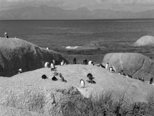
The Peninsula's fauna is less well known than the flora. Historical data gives evidence that the Cape Peninsula was once populated by a variety of larger mammals such as lion, leopard and hyena, however due to hunting and environmental degradation they got locally extinct. The diversity of habitats present contributes to the large bird species count, as does the geographical positioning at a continent's corner. One of the birding highlights of the Park is the Jackass Penguin colony at Boulders Beach (fot.10). The TMNP is home to around 22 snakes and has a variety of amphibians most notably the endemic and endangered Table Mountain Ghost Frog and the endemic Cape Chirping Frog (TMNP Management Plan, 2006).
Namaqua National Park
Geographical location. The Namaqua National Park lies in the Namaqualand geographical region (fig.1) and is known for the wonderful flowering of wild flowers in springtime. The Namaqua NP was established in 1988. The protected area covers about 600 km2 including the Skilpad Wildflowers Reserve.
Abiotic features. Namaqualand, with some of the world's most unique geological formations, can be split into six geographic regions, each with its own distinctive landscape and climate. The Namaqua NP is located in the two central regions: Hardeveld made up of intrusive granite hills and domes and massif of the Kamiesberg uplands.
The topography of the Namaqua NP is characterised by granite outcrops with large round or flat exposed rock separated by sandy alluvial valleys. Four of the highest peaks exceed 1500 m, while Rooiberg (south), the highest land surface in Namaqualand, reaches 1700 m.
Namaqualand`s climate has many unique features: it is the only desert in the world that gets regular soft winter rains. In some years, rain may arrive early or late, compressing the growing season into a 2 to 3 week period. These predictable regular winter rains are due to the Benguela Current and the effect of the inland plateau (Hardeveld). Rainfall is supplemented by regular fog and dewfalls. The Hardeveld receives some 200 mm of rains and the Kamiesberg up to 400 mm. The Benguela Current plays a very important role in Namaqualand's climate, with onshore winds blowing over the cold, up welled waters of the Atlantic Ocean ensuring that summer temperatures are seldom extreme, ranging from 25 to 35oC. Winter temperatures range from 5 to 15oC. Frost occurs in the high lying regions with snow occasionally falling in the Kamiesberg uplands region.
Biome. The Namaqua NP falls within the WWF's Succulent Karoo ecoregion and biome. Arid lands tend to have highly endemic floras and faunas, but are usually relatively species poor. The Succulent Karoo is an extraordinary exception, and is one of only two arid regions in the world that can be considered a true biodiversity hotspot. It harbours a staggering 6356 plant species (in 168 families and 1002 genera) (Driver et al., 2003) and the richest succulent flora in the world (Van Jaarsveld 1987).
The vegetation is dominated by dwarf, succulent shrubs, of which the Vygies and Stonecrops are particularly prominent. Mass flowering displays of annuals (mainly Daisies) occur in spring. Grasses are rare. Less than 0,5% of the area of the Succulent Karoo Biome has been formally conserved.
|
Fot.11. Gazania Treasure-flower –
Asteraceae |
Fot.12. Quiver tree (fot. E. Papińska 2005) |
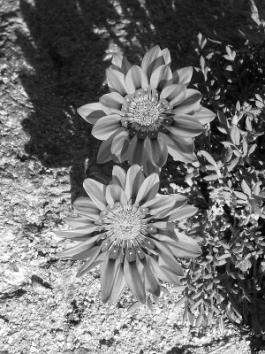
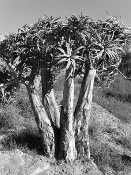
Fauna and Flora. The region is host to 5000 higher plant species, about half of the world's 10000 succulent species. The region is dominated by succulents with little grass and a scarcity of tall shrubs and trees. About 67 genera and 1940 species are endemic to this region. The annual natural spring flower show comprises only about 8% of the area's flora, with very few endemic species. There are 390 species of annuals. About 1700 species are leaf succulents, of which 700 are stone plants and their allies. The region is rich in bulb succulents, with 630 species of geophytes. There are 35 species of trees with 3 endemics: halfmens, quiver tree, bastard quiver tree.
Little data are available for the fauna of the Succulent Karoo. The fauna is rich in endemic species, especially among the arachnids, hopliniid beetles, aculeate Hymenoptera, and reptiles. 22 of the region’s 50 scorpion species are endemic. Approximately 15 amphibians are found in this region, including 3 endemics. Among the region’s 115 reptile species, 48 are endemic and 15 are strict endemics. Endemism is less pronounced among the Succulent Karoo’s bird and mammal faunas. Only 5 of the region’s 226 birds and 7 out of the 78 mammals found in the region are endemic.
References
David M. Olson, Eric Dinerstein, Eric D. Wikramanayake, Neil D. Burgess, George V. N. Powell, Emma C. Underwod, Jennifer A. D’Amico, Illanga Itoua, Holly E. Strand, John C. Morrison, Colby J. Loucks, Thomas F. Allnutt, Taylor H. Ricketts, Yumiko Kura, John F. Lamoreux, Wesley W. Wettengel, Prashant Hedao, and Kenneth R. Kassem, 2001, Terrestrial Ecoregions of the World: A New Map of Life on Earth, Bioscience, vol.51, pp.933-938
Venter, F.J. 1990 - A classification of land for management planning in the Kruger National Park. Ph.D. thesis, University of South Africa, Pretoria
NBSAP - South Africa’s National Biodiversity Strategy And Action Plan, 2005, Country Study, Department: Environmental Affairs and Tourism
Low, A.B. & Rebelo, A.G. (eds) 1996 - Vegetation of South Africa, Lesotho and Swaziland. Department of Environmental Afairs and Tourism, Pretoria
Jacana 2000 - Kruger National Park Ecozone Map by Jacana Maps and Kruger National Park
Park Management Plan, Golden Gate Highlands National Park, South African National Parks, 2006
http://www.kruger2canyons.com/bioregion.htm
Moffett R., 1997 – Grasses of the Eastern Free State. UNIQWA
Driver, A., Desmet, P. G., Rouget, M., Cowling, R. M. & Maze, K. E., 2003 - Succulent Karoo Ecosystem Plan Biodiversity Component Technical Report. Cape Conservation Unit, Botanical Society of South Africa, Cape Town
Van Jaarsveld, E. 1987 - The succulent riches of South Africa and Namibia. Aloe 24
BirdLife International 2007 - BirdLife's online World Bird Database: the site for bird conservation. Version 2.1. Cambridge, UK: BirdLife International. http://www.birdlife.org
World Heritage Site. http://www.worldheritagesite.org/sites/greaterstluciawetlandpark.html
Natural site datasheet from WCMC. http://www.unep-wcmc.org/sites/wh/st_lucia.html
Forest Biome. http://www.plantzafrica.com/frames/vegfram.htm
http://www.sanparks.org/parks/tsitsikamma/conservation/ff/mammals.php
Knysna-Amatole montane forests. http://www.worldwildlife.org/wildworld/profiles/terrestrial/at/at0115_full.html
The Knysna and Tsitsikamma Forests. 2002, Chief Directorate: Forestry. Department of Water Affairs and Forestry
Table Mountain National Park (TMNP) Management Plan, 2006, www.sanparks.org/conservation/park_man/tmnp.pdf