|
|
|
|
|||
|
|
|||||
|
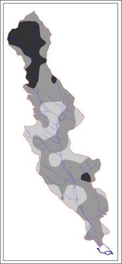
Gukiv basin system |
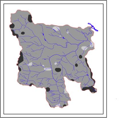
Dereluy basin system |
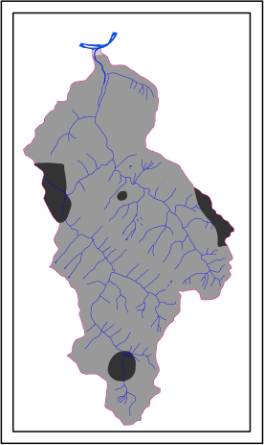
Vizhenka basin system |
|
||
|
Fig.1. Interpretative maps for sustainable
development |
|
||||
География и геология/3. Гидрология и водные ресурсы
Kyryliuk Olena and Kyryliuk Sergey, masters
Chernivtsi Yuriy Fedkovich National University,
Ukraine
Hydromorphological conditions and
basin planning of sustainable development of small rivers in the Upper Prut
River basin
The studied basin
systems are part
of the Upper Prut in the Chernivtsi region (Table 1). Upper Prut Basin system is
one of contrast to natural conditions and landscape structure area that leads
to the activation of many natural processes. However, not many
scientific researches are conducted on the basin system of Upper Prut with hydrological and river-bed sides have been
insufficiently studied. Selected river-indicators are related to the Black Sea type
of water
treatment, the filling mixed with a predominance of rain. For each basin
system there has been studied the features of the hydrological regime and the formation of
hydromorphological characteristics. Studying of hydrological
characteristics held by clarifying passport data in the field during the
2005-2011 years and analysis of hydrological yearbooks. Based on the
analysis of some passport data, longitudinal profile, cartographic material there
were selected
homogeneous areas of channels (HAC) rivers: on the Gukiv - 5 HAC, on the Dereluy and Vyzhenka - 6 HAC in each. Description and analysis of
hydromorphological characteristics of "flow-river-bed" was carried out on
selected units.
Table 1
Some characteristics of Gukiv,
Dereluy and Vyzhenka river
|
River
basin |
Localization |
Watershed area,
mi2 |
Stream
length, mi |
|
Gukiv |
Prut-Dniester
interfluve |
25,35 |
6,24 |
|
Dereluy |
Precarpathian
Trough |
122,07 |
13,26 |
|
Vyzhenka |
Mountain
zone |
43,68 |
11,31 |
For each homogeneous region it is made natural
descriptions (the length; the absolute level, slope, valley bottom width and
its shape; the bed shape characteristic, the high water mark, floodplain and
channel, etc.) and anthropogenic component (riverbed rates, availability of
coastal water protection strips zones, littering, discharges, intakes, sewage,
calculated the transformation of river network). Changes in the structure and
parameters of the drainage system functioning are the result of the display of
transformation and degradation processes that are developing under the
influence of natural and anthropogenic factors. The Gukiv river network structure undergones the following changes:
4 streams ceased to exist, however, the new six watercourses formed. Disappearance
of the first order rivers in the upper basin due to logging within Chornivka
forestry, at the place where the river originates. One of watercourses changed
order from the first to the second. The disappearance of the middle reaches of
watercourses mainly associated with dynamic household activities on the
floodplain. In the river system of Dereluy
it is seen the appearance of new permanent watercourses of the first order,
which previously belonged to the temporary. However, it is also available the
extinction of many streams of the first and the second order. The rate of main
river also changed – it reduced from V to IV. Calculations show that the total
number of streams of the 1st, 2nd, 3rd orders reduced. Such changes can be
explained by transforming of the river
system structure (transition of the second order streams to the first, the third
– to the second, etc.). Many streams in
Vyzhenka river network moved from the temporary to constant of the first
order.
There were analysed anthropogenic activities in the
basin system as a whole - anthropogenic transformation of landscapes, surveying
dangers, nature use conflicts and environmental risks. Comparison of nature for
modification of Gukiv, Dereluy and Vyzhenka basins showed that in Gukiv and
Dereluy basins heavily transformed areas dominate - mostly the lands under
settlements and arable land, the main effects of which for river channel are increasing
the flow of sediment, silt, lateral erosion of pollutant substances, pollution
and household debris, mechanical changes, changes in floodplain landscapes. In Vyzhenka
basin there is different situation - more than 80% of the area is poorly
converted, since there were established protected area and limited economic
activity. Based on assessment of the current state of Gukiv, Dereluy and
Vyzhenka basins there were indicated many environmental conflicts. Most
conflicts in nature use are observed for agricultural and settlement types. The
predominance of areas with high anthropogenic pressure is connected with
intensive plowing, dedicated to the slope surface, medium and low with weak
shared areas using as grasslands and natural pastures. One way to resolve such situation
is to develop a system of nature rationalization, based on pre-planning through
thematic maps generated to identify areas with intense environmental situation,
and the development of river basin management plan.
For each river there were held 2 complexes of
hydromorphological assessment - for Gukiv River in 2005 and 2011, for Dereluy
and Vyzhenka - in 2006 and 2012. For a period of 6 years, there are some
changes in the parameters of flow characteristics, of coast and coastal area,
floodplains. Parameters remain unchanged in river channel, as in such brief
period it is not observed a meandering change, type of river-bed and channel
straightening. For river Gukiv one of the survey
areas (SA) - SA 2 - changed status from "excellent" to
"good". On Dereluy river 2 sites have changed the quality class from
the "excellent" to "good". For Vyzhenka river similar
changes occurred in SA 5. Such changes are related primarily with floods in
2008 and 2010 years. One of the drawbacks of such evaluation is that it does
not involve the assessment of coastal protective strips availability, because
according to that the greatest quality class would be "fair".
Studying of the floodplain and river-bed complexes based on the Framework Water
Directive.
On the studied territory there are following common
anthropology landscapes: creating settlement landscape, agriculture, forestry,
recreational activities, the creation and operation of linear industrial facilities.
Measure of anthropology and indicators of environmental and economic balance
change on selected areas. Totally analyzed and evaluated effect of six
environmental risks of local floodplain system: change in water quality and
development of placer mines as risk of water flow, landscapes anthropogeny as
risk of landscape system and flood, flooding and destruction of the coast as
the risk of social-ecological system.
According to the Draft of Law of Ukraine "About
the Concept of Ukraine's transition to sustainable development" one of the
priorities of regional development in relation to water resources is a further
development of the basin approach to resource management, restoration of the
natural regime of the small rivers and limitations the economic activities in
the catchment area, especially in areas source and water protection zones. Solving
all the problems related to planning of the territory and sustainable
development requires appropriate scientific base and training of qualified
personnel. Scientific knowledge should be provided in various forms, but the
most important values have national databases that contain the minimum required
hydrological information and data of resource use. We have identified factors
that in our opinion are informative about the state of the basin system from
position of its potential sustainable development (taking into account its
natural element). To the main factors belong: the transformation of river
network (the length and number of different order tributaries), anthropogenic
elaborateness, environmental conflicts (by quantity, intense and dynamic
factors), erosional danger, floodplain estimation (by type of use),
manifestation of hydroecological dangers, hydromorphological assessment of
river-bed and riparian vegetation (by class of quality), assessment of land use
and the scrutiny of basins.
Based on the above characteristics Algorithm of ecological
and hydromorphological assessment of
river basin for sustainable development was established. Assessment of any basin
territory is held on the base of relative points.
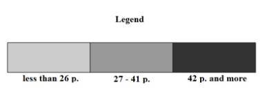
Adverse areas for sustainable development (less than 26 points) in accordance with the SWOT-analysis of
geo-ecological problems and prerequisites of sustainable development are
characterized by the virtual absence of strengths aspects and opportunities and
the presence of weaknesses and threats. Transformation of the river network (by
quantitative and by length) is moderate and intense. For elaborateness of area by
man and machine, it is dominated high transformed and very high transformed
territory. Environmental conflicts are characterized as stable and increscent by
dynamics, high and very high by intense and 4-5 characteristics by the quantity
(conflict with each other on a relatively small land area settlement,
transport,
|
|
|
|
|||
|
|
|||||
|
Gukiv basin system |
Dereluy basin system |
Vizhenka basin system |
|
||
|
Fig.1. Interpretative maps for sustainable
development |
|
||||
agricultural and recreational types of nature use). Erosional danger is
medium and high. Floodplain area is mostly built, with hydraulic structures and
it is modified. Speaking about hydroecological dangers, then on the territories
there is increased and high risk of channel processes, resulting in washout of
land, lost productivity and quality of wetlands, floodplains waterlogging,
flooding and flooding localities active landslide and erosion is high risk
breakthrough pond dams etc. In hydromorphological ratio prevail poor and very poor
quality classes. In land use prominent place is stipulated by cultivated land
and built-up areas.
Areas of moderate sustainable development (27-41 points). In the transformation, erosion and sediment channel
network dominate weakly and medium transformed area. Results of human
activities are converted and medium converted
areas. Nature use conflicts demonstrate themselves as unstable, weak
and 3-4- componented. Erosion danger shows itself as a minimum and weak.
Floodplain is mainly under agricultural lands. Displaying of channel processes
is characterized as mild and moderately dangerous. Among hydromorphological
indicators there are good and satisfactory quality classes. In land use main
place is occupied by other types of vegetation, such as meadow, grasses and
ruderal associations and a small amount of arable land.
Areas favorable for sustainable development (more than 42 points) have many strong points on the internal
environment and opportunities for outside. Weaknesses of internal and
threats of external environment are almost absent. Transformation processes in
river networks are little or no change compared to older years. Here the
available wanly transformed human territory. Among the conflicts in
environmental management there are decaying (the dynamics), weak (in intensity)
and 2-3 - component (by number). Demonstration of erosion processes in a
network of temporary and permanent watercourses is absent or minimal.
Floodplain is in its natural state. Danger of demonstration fluvial processes
is absent or weak. Investigated hydromorphological parameters are related to
the excellent and good quality classes. In land use predominantly indigenous vegetation
takes place.