Master student
Zhomartova Gulnaz
E.A.Buketov
Karaganda State University, Kazakhstan
Using
Thinking Maps in Polylingual Geography Teaching
What are Thinking
Maps?
Thinking Maps were developed as a language for learning in
1988 by Dr. David Hyerle. There are eight maps in this language that are used
by teachers and students for reading comprehension, writing process problem
solving, and thinking skills improvement. Through quality training, materials
and support services, designs for Thinking will support learning communities
with the tools necessary to become successful thinkers, problem solvers,
decision makers, and ultimately, lifelong learners.
 Thinking Maps are
used and promoted in schools of the United States, Canada, the United Kingdom,
Australia, New Zealand, Brazil, Egypt, Ethiopia and other countries1.
Thinking Maps are
used and promoted in schools of the United States, Canada, the United Kingdom,
Australia, New Zealand, Brazil, Egypt, Ethiopia and other countries1.
I have learned about Thinking Maps when I was searching for something
different for my students on the internet. Kazakhstan is a young country, and
educational programs are still being developed. And, I hope that Kazakhstan
will know and discover for itself the benefits of Thinking Maps in near future
and will use them in education system of the country.
What is Polylingual
Teaching in Kazakhstan about?
The President N.A. Nazarbayev spoke about “Linguistic Triunity” in the
Republic of Kazakhstan several times in the course of various formal addresses.
For the first time this idea was read on October, 2006 at the ХІІth
session of the Assembly of People of Kazakhstan where the head of the state has
noted that knowing at least three languages is important for the future of our
children.
Nursultan Abishuly in his Message of 2007 «New Kazakhstan in the new
world» has suggested to begin step-by-step realization of the cultural project
“The Unity of Three Languages”. It was marked out as a separate line of the
domestic policy along with spiritual advance of the people of Kazakhstan.
“Kazakhstan should be perceived all over the world as highly educated country
which population speaks three languages. They are: the Kazakh as the state
language, the Russian as the interlanguage and the English as the language of
successful integration into the global economy”, - said the President. In other
words, the idea of triunity is expressed by a simple and a clear formula: we
develop the state language; we support the Russian language and learn the
English language.
Thereby, Kazakhstan, having headed for mastering three languages by its
citizens, proceeded from today's realities - “Linguistic Triunity” will be
evidence of the competitiveness of the country. The linguistic wealth involves
a powerful socio-psychological effect of «open thinking» loaded to retrieval of new
knowledge. And, the citizens themselves speaking several languages fluently
will be competitive individuals both in the country, and abroad2.
N. Nurmakov specialized boarding school for gifted children is one of
those 33 schools implemented the trilingual teaching since 2007. The subjects
such as biology, mathematics, physics and geography are taught in the English
language for Native Kazakh speakers. The geography subject is taught in 7-9
grades at N. Nurmakov School for 3 years by now.
Thinking Maps in
the geography classroom at N. Nurmakov School
I have discovered for myself that this is what I can definitely use in
my teaching. I did not hesitate at all and have started using this wonderful
technique immediately in my lessons after several training myself at home using
materials and video trainings of www.mapthemind.com/thinkingmaps website.
Thinking Maps helped my students from the very first day, although they
were not familiar with them. It is a very good strategy for English Language
Learners because it takes away the necessity to speak and write English. There
are several students in my classroom, who have the language barrier to speak,
and now, they are able to cope with the fears through sharing their ideas using
Thinking Maps. And, most importantly, I have found that it matches the content
standards of the state.
Although, Thinking Maps are new at school where I teach, they have
become a part of my teaching geography in English.
In my classroom I use Thinking Maps so that students can compare and
contrast, sequence, classify, and specify the reasons of their ideas. They are
much improved in their reading, writing and geographically thinking in
comparison with I had to see at the first time.
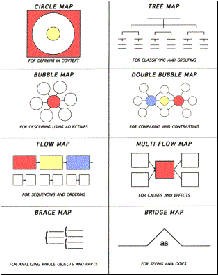
Below, you can see examples of using Thinking Maps in my geography
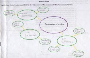
lessons. Those are taken from the Lesson Plan on topic: “Africa’s Nature” which
was made using the Bloom’s Taxonomy. In that lesson students learned to be able
to represent the information using “Double Bubble map”, “Tree map”, “Flow map”,
“Multi-Flow Map” along with diagrams “Spider” and “Fishbone”. I will show only
the part of the lesson from 3 to 6 levels.
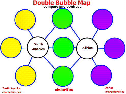
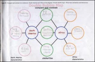
Task 3. Compare and contrast two continents: South America and Africa.
Write their similarities and distinctions.
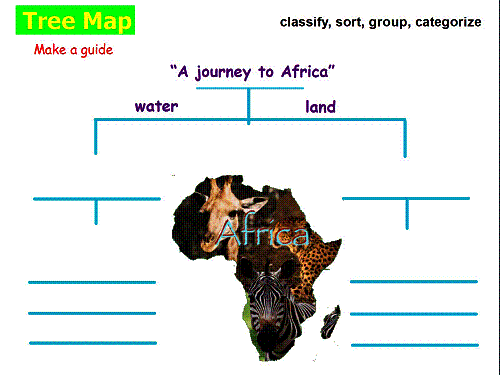
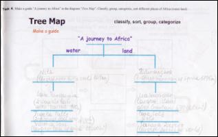
Task 4. Make a guide “A journey to Africa”. Classify, group, categorize,
sort different places of Africa (water-land).
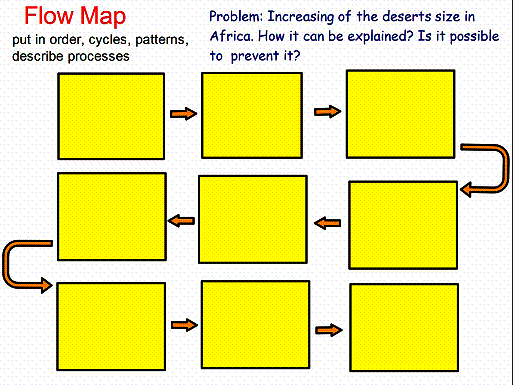
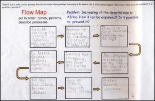
Task 5. Put in order, cycles, patterns, describe processes of the
problem: Increasing of the deserts size in Africa. How it can be explained? Is
it possible to prevent it?
Task 6. Show and relate the causes and effects in the climatic
conditions of Africa in “Multi-Flow Map”.
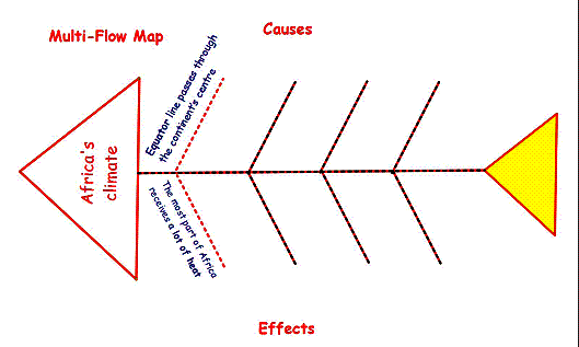
These are the examples of some of the students’ answers.
Conclusions
At the classroom level, I have found:
ü Thinking Maps are
easy for students to use;
ü They are helpful
for differentiation, especially with English Language Learners;
ü I can use them in
my assessments;
ü They are very interesting both
for students and teacher;
ü Students learn more
efficiently and more effectively;
ü I can easily measure students’
knowledge and grade them;
ü I am able to track students’
performance on time;
ü
Once they
have learned working with them, they are able to use them during other lessons
as well;
ü
They can be used in any content area or grade level.
Now, I am sure that Thinking Maps are one of the best methods at
teaching geography in three languages.
References:
1. www.mapthemind.com
2. The Message of the President of the Republic of Kazakhstan «New Kazakhstan in the New
World», 2007