Технические науки/ Горное дело
Ystykul
Karagoz Abubakirovna
Kazakh National Research Technical University after K.I.Satpaev,
Kazakhstan
Eugene
Levin
Michigan
Technological University, USA
Seredovich Vladimir Adolfovich
Novosibirsk State University of Architecture and Civil Enginering
Blagoveshenskyi Viktor Petrovich
Institute of geography Republic of Kazakhstan
TECHNOLOGY OF MEASURING OF AVALACHE SLOPES WITH USE OF TERRESTRIAL LASER
SCANNING FROM CIS COUNTRY VIEW
Introduction
Humans have had a great interest in avalanches since
ancient times, back when they frequently caused loss of life and livestock,
destruction of houses, etc. However, people were not able to discover the
nature of, and especially how to control avalanches, in those days. While many
troubles have been caused by avalanches, a complete avalanche disaster
inventory has yet to be created. The death records of avalanche victims have
been retained in the annals, manuscripts, books and human
memory.
The first mentions of avalanche disasters are found in
ancient descriptions of the campaigns of Alexander of Macedon in the mountains
of Central Asia and over the Hindu Kush into India [1].
The Alps is home to the longest record of avalanche
disasters, with written evidence from the antique and the early Middle Ages.
The first genuine medieval document reporting a death due to avalanche was part
of the retinue of Bishop Rudolph, Christmas in the year 1129 sent to Rome
through the Great St. Bernard [2]. The
Russians had to deal with avalanches in the Alps too. The army under the
command of A.V. Suvorov was going from Italy to Switzerland in the autumn of
1799. The army suffered minor casualties from avalanches at the St. Gotthard
pass and in narrow mountain valley on the way to devil's bridge. There is a
monument devoted to Suvorov's soldiers not far from devil's bridge, in an
alcove, carved into a steep mountain slope. Avalanches overlap it every winter.
In the twentieth century, the largest avalanche
disaster occurred again in the Alps during the First World War, on the
Austro-Italian front. According to the subsequent estimates six thousand
soldiers died from avalanches, more than people that’d died from the result of
military action [3]. Avalanche disasters are not the privilege of the Alps in
Europe. Lists of victims have been maintained in Iceland, Norway, Bulgaria and
other countries. However, the Alps remain as the primary location where
avalanches occur. One of the most horrible disasters happened in the French
Alps in 1970: the avalanche that struck the hotel in Val d'isere killed about
two hundred tourists and the other one pulled down the health resort for
children near Saint-Gervais, burying 80 people - children and staff [3].
Avalanche danger area
covers 124 km2 [4,5] in the mountainous regions of Kazakhstan. The
volumes of the avalanches in the area can reach 1 million square meters. Human
settlements, ski resorts and roads are threatened by avalanches. Eighty seven
people died in avalanches within the territory of Kazakhstan over the past 64
years. Mostly tourists such as climbers and skiers face the threat of
avalanches. Forecasting avalanches, preventive descents and defenses are used
as avalanche protection policies.
Neglecting the avalanche danger can lead to quite
severe consequences and significant destruction of infrastructure, and cause
human casualties. Therefore, research on the identification of avalanche sites
is very important. One of the avalanche areas in Kazakhstan is Ile Alatau
(Fig.1) and Altay [4].
There are avalanche areas along highways
Ust-Kamenogorsk – Zyryanovsk , Ust-Kamenogorsk – Samara and on the railway Ust-Kamenogorsk
– Zyryanovsk in Altai. By the ski resorts of Chimbulak, Almatau (Fig. 2), the
Akbulak, the rink Medeu, the road through the valleys of the rivers Bolshaya
and Malaya Almatinka, Esik and Turgen. Marked hiking trails and climbing routes
are also threatened by avalanches in the Ile Alatau mountains. The number of
avalanche areas which cause danger will be increased in connection with the construction of new ski resorts. A major
ski resort of international class going by the name of "Kokzhailau " is
planned to be built for the winter Universiade close to Almaty in 2017.
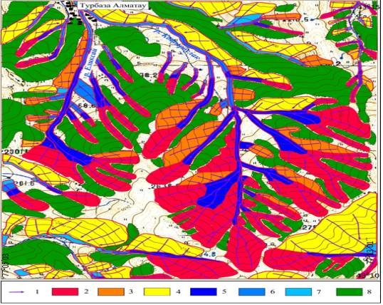
Scale - 1: 25 000
Figure 1. Fragment of map of avalanche hazard in
Almatau
1
– avalanche road: less than 1
– 10 year; 2 –
before 10 till 50
year; 3
–more than 50 year; 4 –less than 10 year; 5
–before 10 till 50 year; 6 – less than 50 year; 7
–forest; 8 – road of avalanche;
9 – watershed; 10
– house
Three methods of research are used to explore and
describe avalanches, as well as to identify unhazardous avalanche areas: 1)
forwarding; 2) map 3) interpretation. Experience in the application of these
methods showed their advantages and disadvantages. Below is the examination of
each of these methods.
Expeditionary
method. The essence of this method is that the expedition is included to study
the area which charts avalanche hazard maps and avalanche cadaster according to
geomorphological, geobotanical and other characteristics. To carry out an
expedition is preferred in the spring or summer, because in winter the traces
of avalanche activity of the past years are hidden under the snow. It is
necessary to collect all the published information about previous avalanches in
the area prior to beginning the field work for choosing the topographic base in
meeting the practical goals of the expedition
Depending on time of the year field work occurs, the
expedition is equipped with appropriate equipment, food and uniforms. Based on
the information collected under this program an avalanche inventory is compiled
and appended to the map of avalanche danger, which is based on this topographic
base. Mapping avalanche risk using this method over large areas has a number of
disadvantages: the high cost of conducting field research; large complexity;
the difficulty of defining the boundaries of the catchment and ways of
avalanches.
The cartographic
method. The core of this method lies describing of the paths of avalanches and
avalanche catchment areas in the analysis of topography according to the
topographic maps. The cartographic method has the advantage compared with the
method of surveying, namely: 1. possibility of accurately defining the area of
catchment and its nature, the paths of avalanches, slope angles and slope etc.,
which is very important for calculations of possible impact force and distance
of snow avalanches. 2. Cost effective. The disadvantages of cartographic method
include: the impossibility of the survey in nature, as there are no changes on the map in the study area that occurred
after the release of those topographic maps; the impossibility of obtaining by
the remnants of snow cornices data on the nature of snow accumulation and
direction of the prevailing winds [6].
Aerial method. In addition to traditional
techniques, investigations of avalanche zones may also includes aerial methods.
Above ground methods include aerial photography and laser scanning (altimetry),
used usually in combination. Airborne methods of monitoring objects have a
number of advantages over spaceborne: high precision products, adjustability of
equipment and shooting options; partial or complete exclusion of works on
geodetic substantiation; high automation level; the possibility of technical
and economic planning with the whole complex of aerial surveys.
It is
necessary to formulate the organizational and economic aspects on the use of
manned aerial systems for monitoring
small areas of avalanche sites.
1. The cost of equipment for a
comprehensive aerial survey and data processing programs is quite high and
ranges from 1.5 to 2 million. Only large organizations are able to purchase and
use such equipment, those specializing in high-volume supply of information about remote sensing.
2.
The weight
of the navigation and airborne radar equipment (lidar) together is 200 kg or
more, which requires to be adapted for shooting aircraft (An-3, Cesna, etc.) or
helicopters (Mi-8T, etc.).
3. The use of manned equipment
assumes the availability of a well-developed field infrastructure: airfield,
depot and equipment maintenance, certified pilots, dispatcher and maintenance
personnel.
4. Obtaining and processing large
amounts of information leads to the creation of separate structural units:
mapping and surveying teams, groups, post-processing of survey data. Again,
this is only available for large specialized organizations.
Costs
of narrow strip of avalanche site laser scanning is significantly higher than
just a simple area scanning. Therefore, to use ALS on extensive grounds and
terrestrial laser scanning (TLS) on the local level is ultimately advised per
[7].
The
analysis of existing methods for modeling snow avalanches has shown that the
majority do not meet our practical needs. Low adequacy of physical/mathematical
representation of the avalanche, description in nature, and the low accuracy of
prediction. can be included as disadvantage of these existing methods. Some
methods cannot be implemented in particular conditions. Therefore, nowadays
identification of appropriate and accurate methods of modeling and forecasting
and analysis of snow avalanches is highly important.
The proposed method for modeling and forecasting snow avalanches can
determine the area, speed, and power of avalanches with high accuracy. For
example the software RAMMS, developed by the Swiss Institute of Snow and
Avalanches, is highly adequate in terms evaluating the physics of avalanches
[8].
The second order dynamics equation forms the basis for numerical
solutions. The height and speed of the snow flow is calculated on specially
designed digital three-dimensional terrain models [8]. Important survey
information is displayed while using the program In this model, the resistance
to the flow of the snow is taken in two types: power dry Coulomb friction with
coefficient µ, and the forces are proportional to the square of the speed of
movement of the snow mass, c the coefficient ξ. The frictional resistance
will be:
![]() (1)
(1)
ρ - the density of the stream;
g– free fall acceleration;
а is the average angle of the
slope in the given point;
H– the height of the stream;
U– flow velocity (speed).
This
model is best suited to describe the movement of very large avalanches
consisting of dry snow. At the same time, RAMMS is not capable of describing
wet avalanches and those of small volume. The authors suggest that a small
avalanche can be modeled by increasing the values of the coefficients µ and
ξ, but this requires pre-setting models. An additional disadvantage of
this model is that the movement of snow is not described at the avalanche
front, in the field of small moving mass, and large coefficients of resistance.
Therefore,
currently searching accurate, convenient methods of modelling, forecasting, and
analysis of snow avalanches is of high importance [8].
In snow and
avalanche research, terrestrial laser scanning (TLS) is used increasingly to
accurately map snow depths over an area of several km². Laser scanners
emit a pulse of light in the near-infrared spectrum. The pulse hits the terrain
or snow surface and is reflected. A photodiode in the scanner detects the
returning pulse, and determines the distance to the target from the travel time
of the pulse. The data from the reflected pulses are saved in a point cloud in
the scanner’s internal coordinate system. When the exact global position of the
laser scanner is known, and three translational and three rotational parameters
exist, the point cloud can be registered in a global coordinate system (Prokop,
2008). Prokop (2008), Prokop et al. (2008), and Grünewald et al. (2010)
report mean deviations between TLS data and reference tachymetry measurements
of 0.04-0.1 m for target distances reaching 500 m, depending on the conditions
and the laser used [9].
We used TLS
snow data to obtain precise quantitative information about snow depths and snow
redistribution. These data are derived by subtracting rasters from different
scan campaigns. Then we correlated the snow depth and distribution data with
the results of the terrainbased parameter and also compared the measured
pattern of snow redistribution with windfield simulations[10, 11].
Active
implementation and practice of TLS in various studies have shown highly
accurate output results, quick shooting and processing, and fusion of new
survey data with traditional methods [9].
The
technology of TLS is an effective tool for modeling and the subsequent analysis
of morphological properties of micro - and nanorelief and reliefoids (snow
cover, vegetation). High-precision digital elevation models allow for
proceeding to a qualitatively new level of morphological analysis [12].
Morphometric analysis
of topography is the base of investigation (DEM). To identify potential areas
of origin of avalanches the following criteria is selected: absolute and
relative heights; slope; curvature in plan; the minimum area of the zone of
origin; maximum unit of avalanche nonhazardous zone within avalanche hazardous
territory.
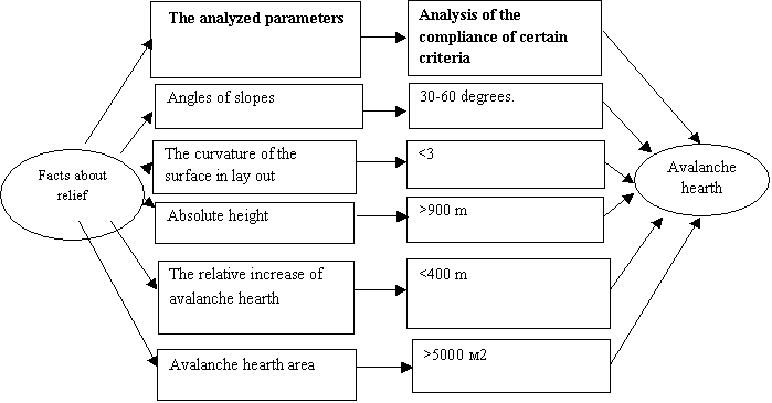
Figure
3. The algorithm of automated selection of avalanche hearth with the use of
morphometric analysis of the relief
Technological scheme of TLS-
1. Technical project planning.
2. Reconnaissance of the area. A rational way of creating and thickening
survey ground takes into account the specific conditions of the area [13]. The
location of the scanner and the placement of targets are outlined. The deadline
of the work is clarified. We have chosen the center of origin of avalanches on
the mountain slope and the installation location of the scanner (Fig. 5). The
first survey was held on 05 A5pril 2015 when there was snow cover. The second survey
was carried out on 02 July 2015 without snow.
1. Compilation scanner survey preparation.
2. Three-dimensional
Terrain Laser Scanning.
1) Installation of the scanner
onto a projected point with a tripod, the height is set to ensure maximum
coverage of the area of interest in one scan (Fig.6)
2) Special stamps spread around the scanner, which show the points of
operating survey object
3) Determination of the coordinates of the centers of special grades
from the basic reference points of the network
4) Scanning of the terrain and objects around a point of scanner
position
5) Identification and determination of approximate coordinates of the
centers of special grades to further quick determination of their position on
the scan
6) Scanning of special stamps with maximum resolution
7) Moving the scanner to the next scan point and repeating the steps
1-6.
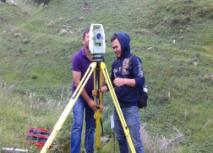
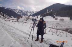
Figure 5. Installation of the total station and scanner to projected point on a
tripod
Laboratory work.
Terrestrial laser scanning data can
be used to create a three-dimensional vector model of objects[15].
Data processing of laser scanner
data is aimed at obtaining high-quality digital terrain models and their
derived digital elevation models. The existence of such models is a
prerequisite for the development of analytical tools, oriented on the
investigation of surface geometry through a number of formalized procedures.
According to the DEM the depth, cross section, height, volume, and speed of
avalanches is determined and the potential to predict an avalanche is possible.
The terrain model is mapped with orthophoto imagery and can be modified based
on the identified errors [15].
Results.
Digital terrain modeling: digital
elevation models (DEM) is one of the powerful and pervasive GIS functions.
Under a DEM (digital elevation model) or DTM (digital terrain model) ) it is
commonly assumed that representations of three-dimensional objects are in the
form of three-dimensional data comprising many of the elevations and Z-samples
at the nodes of a regular or irregular network or a set of records of contour
lines or other structural lines [12].
Therefore,
the concerns of high-precision monitoring of avalanche sites using TLS can be
solved. A practical confirmation of the calculations is necessary. A Land-based
survey of hazardous glacial processes in the highlands is currently taking
place mainly at local areas with a limited observation period.
The issues of exploitation NLS systems: certification and registration
of TLS, obtaining permits for filming, security and insurance photography are
not considered in the article.
References cited:
1.
Kanonnikova
E.O., Philosophy- historical aspects of becoming and development of avalanche
as sciences, Modern problems of science and education). – 2014. -№6. Page 45
(in Rus)
2.
Lossev
K.S. Po sledam lavin (On tracks avalanches). L: Gidrometeoizdat, 1983. Page 134 (in Rus)
3.
Tverdyi
A.B. ,The dangerous natural
phenomena are in mountains // Collection of scientific works KIMPiM №1). Krasnodar, 1999, page 34-57. (in Rus)
4.
Severskyi
I.V., Blagoveshenskyi V.P. Lavinoopasnye raiony Kazakhstana (Avalanche areas of Kazakhstan). Alma- Ata: Nauka, 1990. Page 172 (in Rus)
5.
Atlas
of natural and technogenic dangers and risks emergency to the situation in
Republic of Kazakhstan). Almaty: Kazgeodezia, 2010. Page 264. (in Rus)
6.
Zalichanov
M.Ch. Snezhnye laviny i perspectivy osvoenia gor Severnoi Osetii (Snow
avalanches and prospects of mastering of mountains of North Ossetia).
Ordzhonikidze: Ir, 1974. – Page 141. (in Rus)
7.
Isakov
A.L. , Monitoring of traffic avalanche areas using unmanned aerial vehicles) //
Vestnik TGASU. – 2014, -5, Page 143 (in Rus)
8.
Solov’ev
A.S., Mathematical design of the emergencies related to the origin and tails of
snow avalanches). Voronezh, 2014 (in Rus)
9.
Prokop A., Schoen P., Singer F., et
al. 2013. Determination avalanche modeling input parameters using terrestrial
laser scanning technology. - Proceedings of the International Snow Science
Workshop, 7-11 October 2013, Grenoble, France. P. 2-59.
10. Prokop, A., Schirmer, M., Rub, M., Lehning, M., and Stocker, M., 2008. A
comparison of measurement methods: Terrestrial laser scanning, tachymetry and
snow probing for the determination of spatial snow depth distribution on
slopes, Ann. Glaciol.,
49, pp. 210-216.
11. Prokop, A. and Panholzer, H., 2009. Assessing the capability of
terrestrial laser scanning for monitoring slow moving landslides, Nat. Hazards Earth Syst.
Sci., 9, pp. 1921–1928.
12. Seredovich V.A., Komissarov A.V.,
Komissarov D.V., Shirokova T.A. Terrestrial laser scanning. – Novosibirsck.:
SGGA, 2009 (in Rus)
13. Severskyi I.V., Blagoveshenskyi V.P.
Osenka lavinnoi opasnosti gornoi territorii (Estimation of avalanche hazard of
mountain territory). Alma- Ata, - 1983,- Page 120 (in Rus)
14. Turchaninova A.S. , Determination of zones of origin and
estimation of dynamic descriptions of snow avalanches., Moscow, 2013 (in Rus)
15. V.A. Seredovich, V.N.Oparin, V.F.Ushkin, A.V.Ivanov ,Forming
the bulk of digital surface models pit wall by laser scanning. Physical and
technical problems of mining. Mining informatics, Novosibirsk: SO RAN,
2007. – № 5. – Page. 102–112. (in Rus)