Zygmunt Paszotta
Department of Photogrammetry and Remote Sensing,
Faculty of Geodesy and Land Management, University of Warmia and Mazury,
Oczapowskiego 1, 10-719 Olsztyn, Poland, paszotta@uwm.edu.pl
Web Photogrammetry
– experience and practical examples
Abstract: Interactive
network photogrammetric applications have appeared along with the development
of the Internet. An example of an application which can view Earth images and
execute measurements of distance in these images is Google Earth. The author
claims that it is possible and important to create more advanced
photogrammetric network applications. In this paper, the structures
(architectures) of selected photogrammetric network applications are presented.
In these kinds of applications, internet browsers and Virtual Machine JAVA
(VMJ) are applied by users in what are known as web applications. The
advantages and limitations of such solutions are also described. The author
presents examples of the determination of elements of aerial photo orientation,
measurement executions, DTM and an orthophotomap generation via the Internet.
It is possible to access these examples from the web site of Work Group IV/5
ISPRS
Keywords:
Internet/Web,
Photogrammetry, Application, Programming, Web-Based, Learning, Teaching
1. Introduction
One of positive
features of the Internet is the possibility of disseminating different types of
Earth images. It is a source of popularity for a portal such as Google Earth,
Google Maps, Windows Live Search or NASA World Wind. Usually, users neither
have suitable photogrametric photos nor appropriate software to process them.
In particular, this concerns land surveyors (geodetic), architects, town
planners and students, who want to study the basics of photogrammetry. There
are internet solutions which can execute photogrammetric tasks interactively by
using an internet browser. They are described as Web Photogrammetry. The ARPENTEUR System is an example of a Web
application in which measurements in photogrametric photos belonging to users
of this system are possible (Drap, Grussenmeyer 2004). It is aimed mainly for
terrain photogrammetric purposes, what is strictly connected with limitations
of the storage size of digital images sent to the system. The current data
transfer rate is responsible for the fact that import or export (sending,
transfer) of the whole aerial photo to or from a server takes a lot of time.
Thus, solutions applied, for example, in Google Earth rely on gathering and
storing images on the server. Only their fragments are sent to users. It
guarantees the attractiveness and high speed of such portals. It should be
emphasized that Google Earth is not strictly a web application but a network
application. Other example of a Web application created by Google is Google
Maps. The author tries to explain the difference between these terms in a
further part of the article.
In constructing a
Web photogrammetric application, it can be assumed that photos will be stored
on different computers – data servers. Software which is necessary to read data
from these servers will be installed on another computer called an application
server. Moreover, users will be communicating with the application server by
means of their own software. The above description presents a distributed
application scheme. In view of safety and ease of use, it is assumed that a
user is only using Web browser. This solution has enormous didactic merits. It
can be supposed that technology based on distributed applications is one of the
scientific development paths of image processing methods, along with aerial
photos and satellite images. Therefore, it is an object of interest of the
ISPRS Commission IV.
2.
Architecture of photogrammetric internet applications
The specificity of
Web Photogrammetry arises from the fact that all tasks are performed in the
computer network. Computers and other hardware such as plotters or printers are
connected to exchange data. The photogrammetric data can be stored on
expensive, well-equipped servers, but the majority of the program logic and
user interface can be done by a client (a program accesses a remote service on
another computer by network) on the user PC machine. In general case a client
as a program does not have to be executed in the browser’s environment. It can
be previously downloaded and installed on computers. Thus, it is called a
network application. The concept of Web application includes software that is
not installed on a computer but the package is available as an applet by a Web
browser.
During construction
of photogrametric applications client-server technology and programming in the
Java language is particularly useful. The classic scheme of the structure of an
application in client-server technology is presented in figure 1.
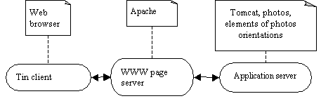

Figure 1. Architecture of Web photogrammetric
application.
We assume that a system customer is only using
a web browser. It means that when a web page is request the server can send not
only the HTML code of the web page but also small programs – called applets. In
principle, a server provides data and a client receives it. However, the
assertion that a client initiates communication by making a request and a
server performs operations to respond appropriately to it is more correct
(Harold 2004). Actions on the server side are conducted by programs called
servlets. Applets and servlets are written in the JAVA programming language and
compiled to bytecode, which at runtime is either interpreted or compiled to
native machine code for execution. In order for photogrammetric applications to act correctly it is necessary to
have a WWW page server, e.g. Apache, and an application server, e.g. Tomcat, to
execute servlets. Additionally, users have to install Java Virtual Machine to execute
applets on the user’s side.
3.
Aspects of network programming for photogrammetric purposes.
Digital photogrammetric workstations are
usually equipped with advanced technology. The process of creating internet
photogrametric applications is not based on copying or translating the source
codes of such systems. It is necessary to build new programs to conduct
definite tasks in an overt manner. They ought to fill gaps in of the user’s
existing software and take into consideration the properties of the network
structure (Harold 2004). All activities connected with programming such
applications depend on the type of software on the client side. In the case of
Google Earth it is a network application. Although ARPENTEUR runs on a Web
browser the users must install some plug-ins. Downloading and permanent
installation of software elements requires confidence in the software creators.
Organizational and psychological aspects are significant here. In the current
case, it is a thin client and it works in browser environment without
additional interference to software (programming) or the operating system on a
user’s computer. Thus, the creation of such applications requires writing
applets and servlets with suitable communication between them (Hunter 2002). It
is essential to understand how the HTTP protocol works because it is used in
sending requests and answers (Hall 2003). Generally, all forms of communication
allows the transfer data of different size and types such as images, elements
of photo orientations, measured coordinates and calculation results. Applets
should also enable simple service of the application by means of a friendly
user interface. On programmer’s side, it means the necessity of using suitable
AWT or SWING event service software (Horstmann 2005). Servlets, as software
installed on a server have the task of servicing all users. However, it is
essential that servlets and applets, through code written in JAVA, must
correctly perform certain photogrammetric tasks. Diagrams presented in a further
part of the article illustrate this.
The fundamental problem of Web Photogrammetry
is also the necessity of transferring whole photographs, which usually require
more than 300 megabytes of storage size. Not only is it a technical aspect, but
it also involves methods of programming. In the previously mentioned system –
ARPENTEUR - user’s files (photographs, coordinates of control point, etc.) must
be uploaded on the APENTEUR server. But the image size is limited to a few Mb
(Drap, Grussenmeyer 2004). Thus, solutions are needed that ensure to deliver a
desirable fragment of photographs via the Internet and visualize it on an
appropriate scale on the client side within a few seconds after the fragment
was established. In our examples of a Web application servlet extracts and
delivers selected fragments of images.
Summing up, the challenges facing programmers
are the following:
-
lack of possibility to use disk storage
-
necessity of transmission and processing of fragments of
images/photographs
-
low execution speed of programs in JAVA
-
low transfer rate between clients and servers
-
necessity of minimization of applet code
The price which is paid for overcoming these
difficulties is the limitation of the functions of internet photogrametric
applications. On the other hand users gain benefits such as:
-
no necessity to install and update software
-
reliability and safety of application resulting from running/executing
it in the internet browser’s environment
-
small/minimal system equipment requirements
-
possibility of using large data resources
-
high didactic/educational merits/values
-
capability of wide and interactive publication of the results of
photogrametric projects.
These advantages to a wide extent satisfy
scientific and didactic needs (Pateraki, Heipke2005). Nowadays, it is difficult
to demand in order to applications can execute photogrammetric tasks on the
photos belonging to users. Aside from data transfer rates, users have many
different reasons not to send their photographs to other computers (servers). It is simply illegal in some countries.
The idea of wide dissemination of
photogrammetric knowledge over Internet is good in theory, but is not currently
commercially profitable. It can be realized by means of various types of
applications. At present, there are only a few interactive applications, which
allow to execute real photogrammetric tasks. More common is the creation of
thematic tutorials or on-line courses. Unfortunately, they usually have limited
interactivity (Pateraki 2005). Such solutions are easier and cheaper to
produce. In a further part of this publication
examples of web photogrametric applications that may be used for
e-learning of Photogrammetry are presented.
4.
Internet Photogrammetry based on web photogrammetric application dedicated to
aerialphotogrammetry.
The several elementary photogrammetric tasks,
which have been made accessible on stand-alone digital workstations to date,
have been programmed based on the architecture of web application presented
previously. The author of this publication has created a set of web
applications for aerial photogrammetry. They are installed on the server of the
Department of Photogrammetry and Remote
Sensing of the University of Warmia and Mazury (www.kfit.uwm.edu.pl/zp). Using a
browser, the following tasks can be performed:
-
choose and visualize the stereopair of a block of photographs,
-
visualize fragments of othophotomaps and take measurements on them,
-
determine elements of photograph orientations (Paszotta 2003),
-
visualize a 3D terrain model by means of an anaglyph,
-
measure the pixel coordinates of homologous points, map them
automatically and determine their coordinates in a terrain coordinate system,
-
automatically measure terrain coordinates of set of points for
generation or verification of a Digital Terrain Model (Paszotta, Szumiło
2006),
-
interactive generate orthophotomaps over the Internet.
4.1. Transformation from a
pixel coordinate system to a fiducial coordinate system.
In order to slightlyshorten the
activity diagram it was assumed that the user chooses a photograph stored on
the server and the coordinates of fiducial marks are sent him. However, the
measurement of the pixel coordinates of fiducial marks is the most essential
problem. This process becomes largely automated (fig. 3). All stages of the
computational process are shown in figure 4, and the results of the example
computation are given in figure 5.
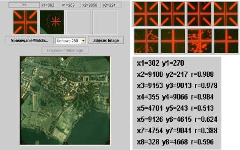
Figure 3. Automatic
measurement of the coordinates of fiducial marks.
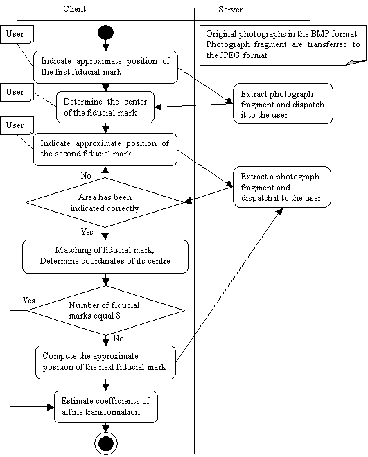

Figure 4. Activity diagram shows steps in
the process of determination of the transformation from a pixel coordinate
system to a fiducial coordinate system.
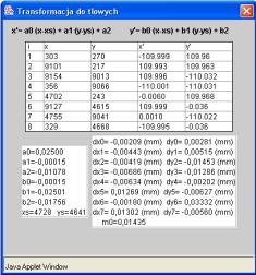
Figure 5. Results of measurements and
computation of inner orientation parameters.
4.2 Relative orientation of
stereopairs and generation of anaglyphs.
A
crucial solution allowing for the Internet realization of this problem is the
possibility of using the image pyramids over the Internet. We assumed that such
pyramids exist on the server and a pair of
photographs was chosen. A sequel to the process of executing the relative
orientation of photographs and the anaglyph construction is described with the
aid of a diagram in figure 7.
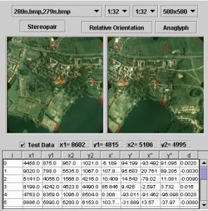
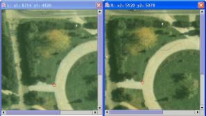
Figure 6. The identification of homologous
points in the process of relative orientation of a stereopair.
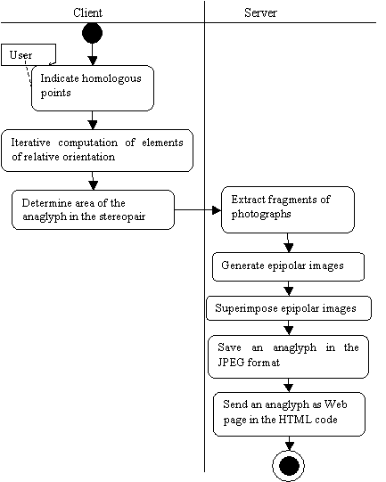

Figure 7. Activity diagram in the
process of relative orientation of a stereopair.
During the process of measurements, coordinates
of at least six homologous points are collected in the table (fig. 6). By
correctly arranging and carefully
measuring homologous points enough accurate
parameters of relative orientation can be fixed in the third or fourth
iteration.
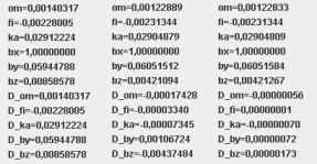
Figure 8. Elements
of relative orientation in the following iterations.
An
anaglyph can be also created over the Internet after running the application
and performing the activities described in figure 7. Users do not have to take
measurements of homologous points and calculate elements of relative
orientation each time they visit the Web site. The set of test data is stored
on the server. If users do not execute the relative orientation of a stereopair
the epipolar images are constructed based on elements determined previously.
4.3 Determination of terrain coordinates.
In order to carry the task of
determination of terrain coordinates over the Internet, it is necessary to have
an opportunity to use fragments of photographs from the different levels of an
image pyramid. . The organization and exchange of data between the client and
the server should be able to measure the pixel coordinates of homologous points
and transform them to the next coordinate system using elements of image
orientation. It was assumed that relative and absolute orientation or exterior
orientation of a stereopair had been executed earlier. The parameters of those
orientations and coefficients of affine transformation are stored on the
server. If, as a result of applying the image matching method, there is the
large set of homologous points, their terrain coordinates can be used for
construction of a Digital Terrain Model. This
problem has already been an object of research and was published in detail
(Paszotta, Szumilo 2006). In this article a
different approach of photogrametric determination of terrain coordinates of
points is presented. Users indicate vertexes of a polygon on the first
photograph and approximate location of these points on the second one. After
these actions, the vertexes of the polygon are matched. Terrain coordinates and
the area of a polygon are calculated automatically. Figure 9 presents the
stages of the task in the form of an activity diagram. The results of its
implementation are shown in figure 10.
![]()
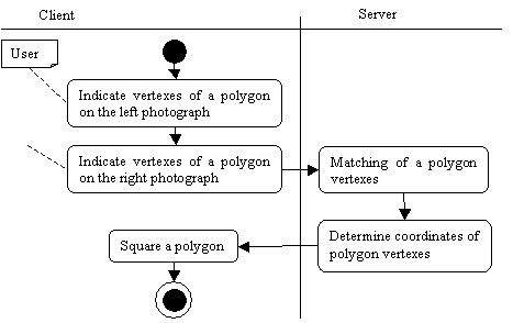

Figure 9. The solution of
interactive squaring of a polygon.
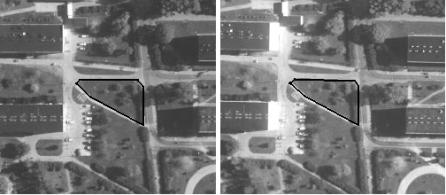
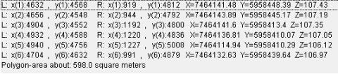
Figure 10. Implementation of the squaring of a polygon.
4.4 DTM and an orthophotomap generation.
The process of
creating orthophotomaps from aerial photographs is complex and requiring the
specialist software on the digital photogrammetric station. However, it turns
out that this process with certain limitations can be executed by the Internet.
The algorithm of orthoimage generation is presented with the aid of UML diagram
(fig 11). The terrain coordinates of points, which are being used to create
digital terrain model (DTM), are measured and calculated in the automatic way.
However, the area of the orthophotomap is small and limited by dimension of the
window of the Internet browser. Thus, in the process of orthoimage creation via
the Internet the author assumed a simplified DTM in the form of the plane.
Orthorectification is made on the server side but the grid coordinate system is
superimposed on the orthophotomap by means of applet on the client side.
Besause of resampling, the created orthoimage has a worse quality than a source
image. Therefore, the source photograph with the system of coordinates is also
presented. In both cases the image and terrain coordinates of point shown by
the cursor are calculated and printed in the header of the Internet browser
window.
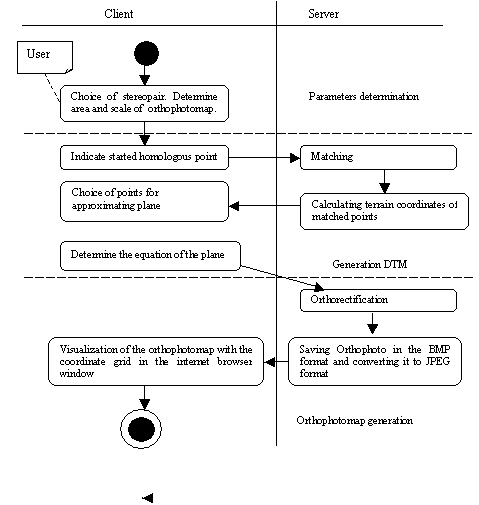

Figure 11. Activity
diagram in the process of DTM and orthophotomap generation.
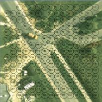
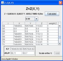
Figure 12. Visualization of set of points for approximating plane and determination of
the plane equation.
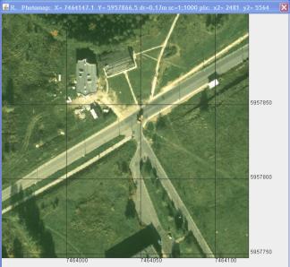
Figure
13. Visualization
of the orthophotomap in the internet browser window.
5.
Conclusion.
The development of Web Photogrammetry methods
is connected with Internet evolution and technical progress in digital
photogrammetry. Web Photogrametry has enormous didactic and scientific values
and is an effective tool of photogrammetry popularization. The slowness of
implementation of web photogrammetric applications stems from the lack of
direct commercial success of such activities. Nevertheless, there are a lot of possibilities
to use these solutions for educational purposes as well as in Integrated
Administration and Control System (IACS). The significance of web
photogrammetry creation was also perceived by International Society of
Photogrammetry and Remote Sensing. This organization created a new working
group (Web-based Geoinformation Services and Applications) as a part of IV
Commission. The described applications located on the Department of
Photogrammetry and Remote Sensing server .They are also accessible from the
ISPRS WG IV/5 too ( http://www.commission4.isprs.org/wg5/).
6. References:
Drap,P., Grussenmeyer,P., Gaillard,G., 2004, Presentation of the web
based ARPENTEUR tools: towards a Photogrammetry based Heritage Information
System, The International Archives of
Photogrammetry and Remote Sensing, Istanbul, Turkey Vol. XXXV-B6, pp.123.
Hall M., Brown L., 2003, Core Servlets and JavaServer Pages.vol. 1: Core
Technologies. PrenticeHall PTR, 2 edition, pp.130-132, ISBN-10 0130092290
Harold E.R., 2004, JavaTM Network
Programming, 3rd Edition. O’Reilly Media Inc., ISBN 978-0596007205
Heipke Ch., 2005: Web-Based Photogrammetric Image and Geospatial
Services – an Overview
Photogrammetric Week 05, Wichmann Verlag, Heidelberg p 157-164
Horstmann C. S., Cornell G., 2005.
Core
Java Volume II Advanced
Features. 7th Edition, Prentice Hall PTR, ISBN-10 0-13-111826-9
Hunter J., Crawford W., 2002. Java Servlet
Programming. 2nd Edition O’Reilly Media Inc. ISBN 978-0596000400
Paszotta Z. 2003: Exterior
orientation and other photogrammetric solutions through the Internet.
Automatic Georeferencing of Aerial Images by Means of Topographic Database
Information. Aalborg University,
pp. 25-32. ISBN 87-90893-47-6, ISSN: 1397-3169
Paszotta Z., Szumilo M., 2006, Application of a statistical test of
hypothesis to check DTM accuracy over the Internet. EuroSDR Official
Publication No 51.