Nurpeisova
M.B., Kurgizbaeva G.M., Tursbekov S.V.
Казахский национальный технический университет, Казахстан
METHODS OF STUDIES OF
DANGEROUS TECTONIC PROCESSES
Efficacy and safety of works while there are mining operations and the
commissioning of facilities that fall into the affected zone of these actions,
depend on the geodynamic state of the strata and tectonic and anthropogenic
processes occurring in it. Meanwhile, the design of mining enterprises are
generally implemented on the basis of very little information about the state
of rock mass, because direct observations at the site of the future object
prior to mining is simply impossible.
These problems and difficulties are eliminated with geodynamic monitoring.
The main objective of the monitoring is to provide timely information about
geo-mechanical processes in the strata and surface and their consequences. This
information is necessary for taking timely preventive measures.
In
accordance with the Regulations on the geological and surveying of industrial
safety and protection of resources in the Law on Subsoil and Subsoil Use No
2828, Law on natural and anthropogenic emergency situations, the Regulations on
State monitoring of subsoil of Republic of Kazakhstan, surveying services keep
monitoring subsoil. This includes the processes of rock and earth surface
movement, geo-mechanical and geodynamic processes while subsoil use in order to
prevent harmful effects of mining on capital mining, objects of the earth
surface and environment.
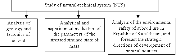
Figure 1 shows the projected structure of methods of study and forecast
of dangerous states in the natural-technical system, taking into account the
full range of geophysical and geodetic measurements and their joint processing.
On the basis of the analysis
of geology and tectonics of the area, numerical modeling and experimental
assessments of the stress state in the mass “energy-zones” are allocated; they
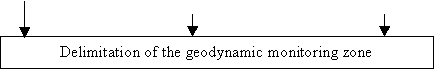
define the boundaries of the geodynamic monitoring zones. Then the monitoring
of the danger zone is organized which includes mainly control of the
deformation and the parameters of geophysical fields.
Reliable
information on the deformations of rock mass can be obtained by direct geodetic
observations on the geodynamic grounds. Earth surface shifting (ESS) are studied
by the method of re-leveling according to the first class method, when
measurements are analyzed exceeding by sections between adjacent benchmarks. Leveling technology should comply with accepted methodology.
The principle of leveling is based on
the processing of the encoded signal (obtained from the slat through the lens).
The microprocessor calculates the reading of
the slat and the corresponding horizontal distance between the slat and level. The measurement results are stored in the REK of WILD
GRM 10 module with the subsequent transfer of data into the computer and data
processing with the special program. The advantage of this system is the
simplicity of measurement, trueness of readout and writing, automatic
calculation of heights during the measurement and recording of data.
![]()
![]()
![]()
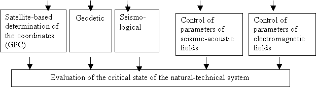
Figure 2 - Scheme of methods of study and
prediction of geodynamic phenomena in the NTS
With increasing accuracy and
efficiency of geodetic measurements the range of problems is expanded. Modern
geodesy can make a significant contribution to their solutions. One of these
problems is the detailed study of anthropogenic processes. Its decision would
create permanent operating geodynamic anthropogenic grounds, based on regularly
performed geophysical and geodetic observations with the interpretation of
their results from the viewpoint of geodesy.
High-precision geodetic
observations are conducted on the geodynamic grounds by the surveying services.
The increased volumes and intensity of mineral resources development produce
the beginning of anthropogenic disasters that are associated with certain
shifts and subsidence of earth surface.
Technology of satellite system
(GPS - Technology) turned out to be very effective among the modern methods and
tools for the study of displacements and deformations of the earth surface. Satellite systems GPS (Global Positioning System) are necessary for
creation a basis for the calculation of
deformation and geographic information systems that allow predicting the
parameters of geodynamic processes. Along with the GPS-technology
systematic observation are conducted of ESS with tachometers and digital levels
for different areas of intensive mining of solid minerals.
Literature:
1. Nurpeisova M.B., Kyrgizbayeva G.M.:
Guidelines for monitoring pitedges deformations and assessing sustainability. -Almaty, KazNTU, 2003.-33p.
2. Nurpeisova M.B., Bekbasarov Sh.Sh.
Environmental problems of mineral resources
development. - Almaty, 2006, Journal of KazNTU .- P.3-5