Физика/5.Геофизика
C.t.s. Ponomareva M.V., c.t.s. Pak D.Yu., Vdovkina D.I., Nurtaza Zh.
Karaganda State Technical University. Kazakhstan
Reservoir current saturation at
Kumkol deposit
according to nano-electrical logging
date
The tasks faced by
subsoil users are to maximize oil recovery efficiency and to involve
undeveloped reserves to production. To identify such undeveloped reserves neutron
methods such as C/O logging are used, however, these methods have significant
limitations: shallow radius of investigation, inability to survey perforated
intervals, interpretation complexity (measurement data have to include multiple
influence factors, rock porosity, shale and carbonate content). Therefore, the
innovative method of nano-electrical logging (NEL) which allows an evaluation
of reservoir current saturation through cased walls comes forth as a relevant
and efficient method.
Nano-electrical logging is an electrical
well logging method which provides continuous measurement data. NEL is used to
obtain electrical properties of rocks located outside borehole casing filled
with any fluid. Borehole casing does not affect the measurements. Owing to the
large radius of investigation (starting from 2 meters) NEL provides completely
new capabilities in terms of oil and gas producing horizons survey. NEL can be
used to:
– determine true
specific formation resistivity from 1 to 100 Om-m with measurement error ±2%;
– identify unknown or
uninvolved in production oil and gas horizons;
– determine and
ascertain water/oil and gas/oil contact locations;
– determine current
oil and gas content of horizons;
– determine formation
porosity.
Analysis
of NEL features involved field trials and interpretation of the acquired
geophysical data using electrical logging equipment through the casing to
evaluate current saturation of Cretaceous and Jurassic producing horizons at Kumkol
deposit. Kumkol deposit as an administrative unit is located in Dzhezdinskiy
Destrict, Karaganda Region, Republic of Kazakhstan. The distance to Kyzylorda,
Regional Center, is 180 km. Geographically the deposit is located in the
southern part of Turgai depression. Kumkol deposit includes Mesozoic and
Cenozoic deposits underlying Early Proterozoic basin. Kumkol deposit consists
of terrigenous rocks: sandstones, shales, silt stone, and argilletes.
Geophysical
surveys were conducted for two wells (different results obtained) at survey
interval of:
Well
X1: survey interval: 1120–1114m (in increments of 0.5m), 1114–1090m (0.2), 1090–1085m
(0.5), number of measurement points – 142.
Well
X2: survey interval: 1288.4–1235m (0.2 m), 1157–1152m (1.0m), number of
measurement points – 273.
The NEL
interpretation results revealed:
1. Behind
pipe interval (J-I, J-II horizons).
2.
Perforated interval (J-III) located immediately at the bottom hole zone and
used as supply interval.
3. Rt depth shift (1.6m) and good
correlation (when adjusted to guide bed) with open hole logs.
4.
Water encroachment of J-I horizon.
The
complex interpretation results are shown at the table, figure 1.
The
conducted field trials revealed that electrical logging through casing stands
out among other methods used to evaluate current saturation (C/O logging, TDT
log, pulsed gamma-ray logging):
1.
Greater depth of investigation which allows obtaining results for reservoirs
with inactive invasion zone.
2. Availability of
“comparison” logs (there is an archive of open hole logs completed at the
drilling stage available for the majority of wells regardless of their age).
This enables visual identification of the changes that have taken place since
putting the wells into operation.
3.
Relative easiness of interpretation (fewer interim calculation factors between
the measured parameter and remaining saturation) which increases its adequacy.
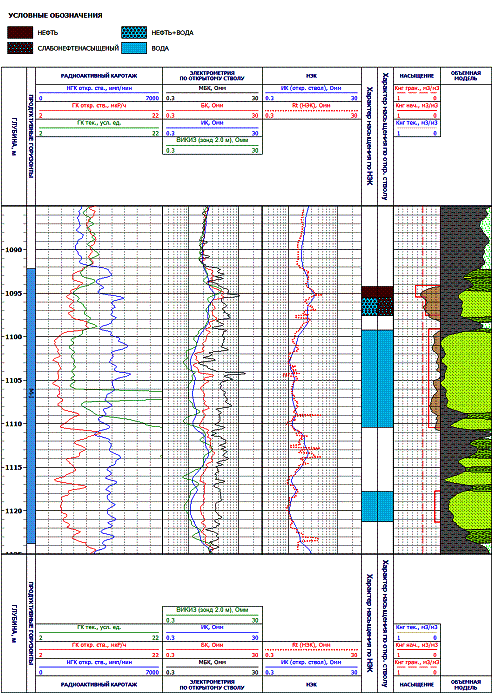
Figure
1 – Evaluation of current oil saturation using nano-electrical logging
References:
1. Itenberg S.S.,
Interpretation of well logging results.–M.: Nedra, 1998
2. Catalog Western Atlas
International. М.: 1991