Technical
sciences / 2. Mechanics
Ph.D., Gnativ1
R.M., ph.D., Yakhno2 O.M., Gnativ1
I.R.
1- NU "Lviv Polytechnic",
2- NTUU
"Kiev Polytechnic Institute",
Influence of
quarrying on the change of longitudinal profiles in the mainstream of the river
Stryi
The quarries of rubble stone, gravel and gravel-pebble
mixture influence on the modern geochemical conditions of the
Steady location of sand and gravel sediments
in the mainstream, floodplain and terraces above the floodplain is a marker of
the fixed local base of channel erosion [1]. Floodplain sediments are
constantly updated and supplemented, they migrate and change the direction of
flow within the floodplain due to their transference downstream from the
mountainous part of the basin. Within the Ciscarpathia
these sediments are the aquifer of the unique Stryi groundwater
deposits with the depth up to
Intensive
career selections of sand and gravel material have in the mainstreams discrete character
and different length. Levelling of the river bottom are
made by some further floods and expenses that are capable to deform the
channel, that are called channelforming.
Extraction of gravel and pebble sediments, that
are often realized on the pretext of clearing the river beds, eliminate
sediment and islands in order to prevent the negative impact of the passage of
floods is not always justified on geo-ecological side. In practice, such
activity leads not only to a decrease in the local base of erosion, destruction
of the banks and the deterioration of water quality, but also adversely affects
the spawning migration and fish spawning in the Striy
river basin. Recently is observed a
significant volumes increase of quarry exploration in the rivers
Especially dangerous for the
quality of natural waters is uncontrolled taking off of the channel deposits.
The volume of unaccounted mining of the gravel-pebble mixture up to 20 times exceed
their introduction from the upper sections of the basin. Uncontrolled mining
leads to disruption of the surface layer of the channel bed, causes sharp
decrease of the river bed resistance degree to the growth of erosion processes,
increases the speed of conversion of microelements in the soluble form. It affects especially negative the natural water quality
of river basin.
It is established that the active taking off of the
soil from the river beds quarries leads
to decrease in the levels and consequently to increase in inclinations and
speeds of water flow. The feature of the speed longitudinal distribution above
the quarry excavation is a reduction of the speed average from upriver slope to
the central part of the quarry and increase - to the downstream. The ratio of
average speeds on typical quarry areas at different periods of their development
are 0,68-1,10. Extraction of sand and gravel in the river bank area of the
leads to the formation of water eddy zones width of 20-
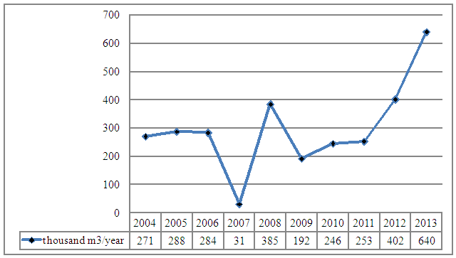
Pic. 1.
Dynamics of extraction of gravel- pebbles mixture in the rivers basin [2]
It is established, based on
experimental studies, that the extraction of sand-gravel mixtures and building
of the structures, correcting the river beds, has serious negative consequences,
first of all - the lack of alluvions below the
quarries, infringement of the kinematic structure of the flow, that affects the
water quality.
Литература:
1.
Явкін
В. Розвиток базису ерозії басейнів Прута, Черемоша та
Сірету/ В.
Явкін, А. Кирилюк, М. Цепенда//Річкові
долини. Природа-ландшафти-людина. Збірник наукових праць. - Чернівці: Рута,
2007. - С. 258-266.
2.
Мінеральні
ресурси України /ДНВП “Державнийінформаційний геологічний
фонд україни ”.- Київ, 2014.- 270с.