Современные
информационные технологии/Компьютерная инженерия
Master student Ibrayeva N.N.,
students Amantaikyzy D.,
Baikara A.T., Mukhambetova M.A., Tuleubaeva F.M.
Research supervisor
Candidate of Technical Sciences Kurmanov B.K.
Kazakh-British Technical
University, Kazakhstan
Simulation Modeling of Urban Traffic
with the Use of GPSS World
The rapid growth of the number of vehicles leads to an
increase in traffic in the cities, the consequence of which is shown in the
aggravation of traffic problems. Particularly acute they appear in the nodes of
the road network – crossroads. There delays in traffic increase, long queues
and huge traffic jams appear; it causes a useless fuel consumption, as well as
increased wear of transport units and components. From an environmental
perspective, the variable mode of movement, frequent stops and congestion of
vehicles on the crossroads are the causes of high air pollution with the
products of incomplete combustion in the city. An increase in the intensity of
traffic and pedestrian flows also makes a negative impact on the road safety.
Today, there are over a dozen different models
describing the traffic flow [1]. Simulation models solve the problem of
constructing mathematical models that can adequately describe the behavior of
the traffic flow and correctly reproduce the parameters and characteristics of
the movement. The article shows the simulation model of the behavior of traffic
flows on the crossroads using GPSS World simulation system [2]. The paper
proposes a simulation model of the traffic on the city block, which is an
intersection of several streets (see Figure 1). It is assumed that at each
crossroad traffic lights are installed, in the figure these traffic lights are
indicated by circles and numbered: 10, 20, 30 … . The traffic through the streets is two-way. In the figure the
possible direction of vehicle is indicated by arrows and numbered. Turn left at
the green traffic light is possible in the absence of oncoming traffic. Cars
can drive into the block by 12 streets. In the figure, bold arrows indicate
input streams of cars. The interval of cars coming is a random variable,
subordinated exponentially. In the absence of interference the car passes the
crossroad in a given time. There is given a probability of the car to go
straight or to turn left or right on the crossroads.
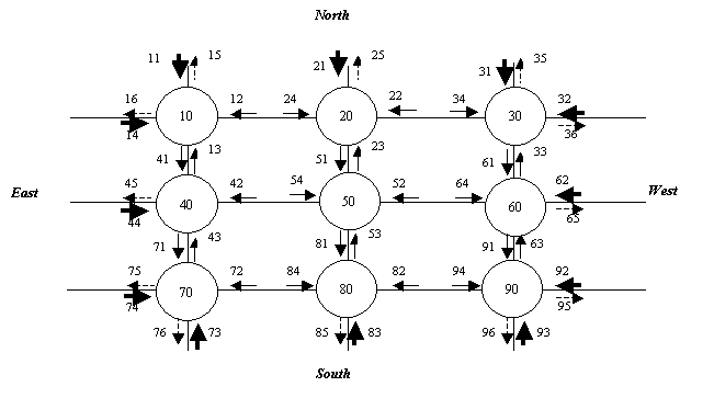
Figure 1 – The scheme of traffic on the city block
It is assumed that all the cars on the block do not
stop. In the absence of congestion, the car can pass the road from one node of
intersection to another node for a random time, distributed under the normal
law. In the case of severe congestion, there is given a number of cars that can
accommodate from one intersection node to another intersection node. If the
section of the street where the car wants to go or turn is filled, it can not
pass through the traffic light, even if there is a green light. It is assumed
that in the streets that go from blocks (in the figure they are shown by dashed
arrows) there is no congestion, i.e. these streets cars can pass without
delays.
There was developed a simulation
program consisting of 20 segments, a fragment of which is shown in the Figure
2. 1 sec is adopted as a unit of time.
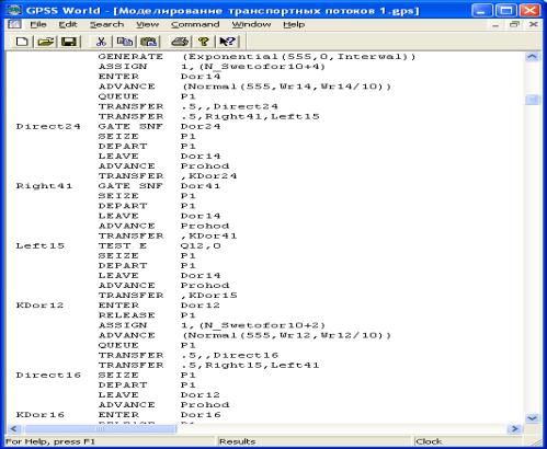
Figure 2 – A fragment of GPSS-program
In the first segment there is the original data set:
the average interval of arrival of cars in a city block, the length of cars way
through the intersection (with no interference), the rule of switching the
traffic lights, the travel time from the intersection to the intersection (with
no interference), the number of cars that can be on the road from intersection
to intersection. Next nine segments simulate traffic flows at intersections.
Another nine segments simulate the operation of traffic lights at intersections.
In the 20th segment the situation on the crossroads in every second
is fixed (the state of queues, traffic condition, the presence of vehicle at
the crossroads and on the streets, etc.) in order to animate the movement of
cars on the city block. Finally, the 21th segment defines the end time of the
simulation.
For observation of the simulation on
the roads there was developed a program written on Java Script, allowing
recreating the dynamics of the car movement by the results of historical data
provided by the GPSS World system in a text file. Figure 3 shows a screenshot
of the process of dynamic mapping of urban transport.
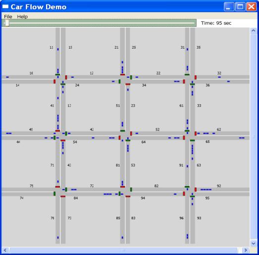
Figure 3 – Visualization of the simulation of urban traffic flow
On the developed model the length of the queue,
forming at the traffic light under the different switching the traffic light
laws (also when the switching time is determined by a function that depends on
the length of the queue formed at a traffic light), was assessed.
Of course, by the increasing the size of the block
under consideration the complexity of the model increases significantly.
However, the use of GPSS World allows moving gradually from simple to more
complex models step-by-step, so it reduces the overall complexity of the
construction of complex models. The degree of the specification of simulation
models of the processes is not limited, so it allows increasing the degree of
their adequacy.
References:
1.
Introduction to the
mathematical modeling of traffic flows. Ed. A.V.Gasnikova. -M .: MIPT, 2010.
2.
GPSS World Tutorial
Manual. Copyright Minuteman Software. Holly Springs, NC, U.S.A. 2001.