Morphology of the Bolozivka
River valley (upper Dnister basin, Ukraine)
in the light of morphometric
analyses with the use
of interpolation methods and
GIS
Hołub
B.1, Yatsyshyn A.2
1 Institute of Earth Sciences, Maria
Curie-Skłodowska University, Kraśnicka 2cd, 20-718 Lublin, Poland,
e-mail: beata.holub@gmail.com; 2
Faculty of Geography, National Lviv University, Doroshenka 41, 29-000 Lviv,
Ukraine, e-mail: jacyshyn@yahoo.com
Introduction
For
over 100 years the Bolozivka River valley has aroused intensive interest of
Ukrainian and Polish geographers who carried out or still conduct
geologic-geomorphologic studies in this area. The first scientific description
of the Bolozivka River valley was presented by Romer (1906). In the next years Rudnicki (1907), Teisseyre
(1938), Przepiórski (1938), and after many years Gerenczuk et al. (1966)
and Demediuk (1969) published papers concerning this valley. One of the most
important scientific conclusions was that about the valley functioning as a channel
draining meltwater eastwards during deglaciation of the Scandinavian ice sheet
in its maximum extent (San 2).
The
purpose of this work was to make more detailed morphometric investigations and
preliminary verification of hypotheses on the geomorphological development of
the Bolozivka River valley. When first hypsometric maps appeared, morphometry
became the main source of information about surface features (Szumowski 1967). In our times the most
important data carrier about relief is numerical model of land surface, which
is used in this paper for quantitative characterization of ground surface in
interpretation of morphometric-statistic analysis. Main physical parameters of
topographic surface (altitude a.s.l., gradient, slope aspect), and their
derivatives (relative heights, mean gradients, etc.) together with other
factors influencing the development of relief (e.g. tectonics) are pinpointed
in time and serve for making the complex study of morphogenesis of the examined
area.
This work presents the
preliminary results of the investigations, which are in progress, and is a
prelude to a complex study on the palaeogeomorphological development of the
Bolozivka River valley with the use of GIS analyses.
Localization
Particular localization of the area indicates its exceptional history of
evolution. The Bolozivka valley is situated in the border zone of watershed of
two big rivers: Dnister on Ukraine and San in Poland. Modern day they belong to
separate hydrological systems, but in the past they were common connected in
period of functioning of water flow (Teisseyer 1938, Demediuk, Stelmach 1980,
Yatsyshyn, Plotnikov 2004). The European Watershed on length of
Bolozivka is a river of the third category. As the biggest left-sided
inflow of Stryvigor decides about the asymmetry of its basin. Eight kilometers
below the Bolozivka mouth the Stryvigor River runs into Dnister River.
According to the geomorphologic division of Carpathian Foothills based on
genesis and age of forms, the basin of upper Dnister is located on San-Dnister
moraine-fluvioglacial alluvial plain (Cys 1962). Another division with leading
criterion of partition which presents
the morphostructure of Carpathian Foreland locates studied area in Carpathian
Foothills- Przybeskidzie in the borders of region Stryvigor Upland
denudation-accumulative with fluvioglacial forms on the south and in the region
San-Dnister undulating and hilly upland with glacial and fluvioglacial forms on
the north (Krawczuk 1998).
The valley of Bolozivka is located on the external edge of Eastern
Carpathian Foreland (Geological Map 1977), within Stebnica region which borders
from south upon peri-carpathian salt formation (Miocene). Both layers
influenced by pulling flysh masses of Carpathian elements were overfold on falling
on them, younger Dashava layers on north (torton-sarmat) (Tołwiński
1956).The foreland basin is filled with neogenian material which in this part
reach the biggest thickness (Tołwiński 1950).
Current state of research over the relief of Bolozivka valley
According to last geomorphologic researches there are created in
Bolozivka valley several heteroaged (Eopleistocene-lower Pleistocene) and with
different rank (interglacial and interstadial) river terraces (Yatsyshyn,
Plotnikov 2004). On the eastern slope of Radycz hill maintained denudational
fragment of higher Pliocene Krasnoy plain (Demediuk 1983). It is the oldest
recognized level in upper part of Dnister basin. Interglacial terraces
consisting on the first period of Bolozivka valley evolution, include two Old
Quaternary terraces: Eopleistocene VI terrace (Łojewoj level) and lower
Pleistocene V terrace. Both terraces create enough readable strips which
appoint outlines of Eopleistocene – lower Pleistocene ice-marginal valley,
stretched crosswise the present surface of Bolozivka valley. It is obvious that
the ice – marginal valley must had been created by huge left tributary of pra
Dnister (Romer 1906, Rudnicki 1907, Teisseyre 1938, Przepiórski 1938).
It is testified by litological composition of alluvial deposits in which we
find Carpathian material. We consider that both terraces were created during
erosive and depositional activity of another river, not the Bolozivka. It is
possible that these are the trails of some pre-glacial (older than a period of
maximum thrust of Scandinavian continental glacier) pra-Wyrwa (San?) valley,
which at that time led water to the Black Sea basin eastwards.
There
are also interstadial terraces which are representing in this area by three
terraces remained on the banks of the Bolozivka valley (Yatsyshyn, Plotnikov
2004). They are residuum of three recession periods in second deglaciation (=
Krukienice) phase of San 2 glacier (= oki). They cut across European watershed
and go into the river valleys which belong to San basin. These terraces are
very well visible in the morphology of the valley, especially the surfaces of
terraces, behind exception of second one. The transitions between them are
visible in relief and structure of their profiles. There are marked horizons of
fluvioglacial sediments, gravelly and sandy materials on geological profiles, which correlate to each
other. There are however parts in the valley where the borders of terraces
decline and their surfaces divide into separate, hypsometrical different
blocks. As well in the surface of fluvioglacial horizons they loose their
sharpness. There in another parts of the valley opposite situations, the
terrace looks as a morphological homogeneous surface, but its horizons of fluvioglacial
material are broken into two separate blocks with lots of hollows with
different structure and unknown genesis.
Methods
In order to determine the spatial
arrangement of morphological elements of the Bolozivka River valley and
describe in detail the values of corresponding indices, a digital elevation
model (resolution of 5 m) of the area is worked out. The relief model is based
on the digitally processed analogue topographic maps at a scale of 1 : 25 000.
The raster model of land surface is the
database for calculation of most morphometric characteristics, and also the basic
layer for other more complicated analytical operations. One of basic layer is
the real gradient map, which is used to determine the hypsometric levels of
land surface within the Bolozivka River basin. Classification of all determined
levels according to hypsometric criterion, with the river channel as a constant
reference point, permits to verify the paleogeomorphological data. These
operations are additionally supplemented with the reconstruction of terrace
levels on the basis of simulated filling of river valley-bottom up to the given
level over the river channel. The obtained visualization of the Bolozivka River
paleovalley-bottom permits also to follow through the stages of formation of
the European watershed.
The levels of terrace sub-Quaternary
socles are identified by the reconstruction of the bottom of alluvial deposits
on the basis of interpolated points with known heights of material occurrence,
obtained from boreholes. As the spatial distribution of boreholes is irregular
and concentrated, the selected springs of the Bolozivka River tributaries and
other rivers in the area under study are also used in interpolation in order to
fill in the unsampling. The altitudes are taken from the numerical model of
relief, which reproduces the configuration of the terrain in continuous way,
unlike linear way characteristic for topographic map. After many attempts of
interpolation, the method of minimum curvature spline function has been
selected. This method is not dependent on surface geometry, so the result is
not influenced by the number and distribution of measurement points. We obtain
a smooth and aesthetic surface (Magnuszewski 1999). Altogether 284 points (104
from boreholes and 180 springs) are used for interpolation of the alluvia
bottom.
Morphometric chacarteristics
and sketch of palaeogeomorphological interpretation
The Bolozivka River basin is stretched
along parallel of latitude. Its area is 273,58 km2, and the
perimeter is 113,46 km. Mean width of the basin is 7,4 km. In its central part
the basin is only 4,8 km wide. In the eastern part it reaches the maximum width
of 14,3 km, and in the western part – 10,8 km. The width of the valley is
practically the same along the whole Bolozivka River as noticed Romer (1907) in
the first scientific paper about relief of the upper Dnister River basin. The index
of basin elongation is very high (0,5). River valley gradient is low in our
times (0,74‰). Maximum relative heights in the basin reach 251,36 m, and mean
ones – typical both of northern and southern valley sides – 12-15 m.
The 36,7 km long axis of the basin is
slightly longer than the length of river channel measured along a straight
line. The real length of the Bolozivka River channel is 43,13 km, and the index
of river sinuosity, calculated from the spring to the mouth, is 1.18. The mean
river gradient is 0,96‰. It consistently decreases from 2,8‰ in the western
part to 1,57‰ near Belici village, 0,96‰ downstream of Rogozno village, and
only 0,41‰ in the eastern part of the valley. These values are not similar to
the mean river gradient in the whole basin that is 15,19‰. River gradients of
the greatest tributaries of the Bolozivka River, e.g. the Konivka River (5,03‰)
or the Rogozno River (3,67‰), are several times higher. Worthy of attention is
a tributary flowing into the Bolozivka River upstream Vankovivi village, i.e.
the Bolotna River. Its valley is similar in shape to the Bolozivka River
valley, and has probably trough origin. The Bolotna River gradient is
surprisingly low (0,55‰), and the channel profile unnoticeably passes into the
Bolozivka River profile, which is its continuation. The longitudinal profile of
the Bolozivka River is in turn continued by the longitudinal profile of the Stryvigor
River, and then the Dnister River to the mouth of the Bystrycja River (Romer
1906). This fact evidences the similar type of morphogenesis in the whole basin
of the upper Dnister River.
The analysis of gradient map and hypsometry
of the valley bottom of the Bolozivka River indicates that 2-3 m high steps
occur in some places. Downstream of each such step the river channel is
strongly bended (Fig. 2). An important observation is also the occurrence of
the mouths of greater tributaries of the Bolozivka River upstream of the
mentioned steps. It turns out that the faults occur in the sub-Quaternary
basement. They are probably associated with tectonics of the Carpathians and
upper Dnister depression. The influence of karst activity in saline formations
of the Miocene substratum is not excluded. Similar phenomena are described from
the Dnister River valley, near Kornalovici village (Demediuk, Sokurov 1974).
However, this question demands separate investigations, which we want to undertake
in the nearest future.
The carried out analysis of
morphometric differentiation of morphological elements in the Bolozivka River
valley (bottom, sides, and watershed area) supplements the former studies of
the valley relief with many details. Within the Bolozivka River basin there are
distinguished 17 different hypsometric levels, with the altitude of river
channel as a constant reference point. This altitude changes along the valley,
and in four distinguished sections (Fig. 2) its mean values are as follows: 269
m a.s.l. (B1), 274 m a.s.l. (B2), 281 m a.s.l. (B3), and 286 m a.s.l.
(B4). The list of all hypsometric levels
(name taken due to the only criterion of division, i.e. relative heights) is
presented in Fig. 3A. In this stage of our investigations these levels are also
related to the Bolozivka river terraces though the correlation demands
verification with geological data.
In the first section (B1) of the basin,
from the mouth of the Bolozivka River to Sadkovicy village, there are 11 hypsometric
levels preserved on both sides of the river. The second section (B2), upstream
of Sadkovicy to Belici village, is asymmetric. Within this section, 12
different hypsometric levels are distinguished on the southern side of the
valley, and on the northern side only 9 but better visible. In the third
section (B3), upstream to Bukova village, there are 14 levels on the southern
side and 12 on the northern side of the valley. The last section (B4), from
Bukova village to the Radycz hill, is very asymmetric. On the southern side 16
hypsometric levels are preserved, and 8 on the northern side.
The lowest distinguished level is
associated with the Holocene floodplain, which occupies the bottom of the
Bolozivka River valley (Fig. 3F). The width of floodplain is almost constant
(1,4 km). It should be noticed that the surfaces of river terraces are very
well visible in the relief of the northern part of the Bolozivka River valley,
between Rogozna village and the Bolotna River valley. All left-bank tributaries
of the Bolozivka River flow from NW-SE. The river terraces are also inclined in
this direction (compare Fig. 2). This direction probably follows the flow route
of fluvioglacial waters of the retreating San 2 ice sheet. This hypothesis is
confirmed by the sub-Quaternary basement relief (Fig. 4B). As the map is
obtained by interpolation method, the reproduction fidelity of land surface is
different. The areas with the most correct interpolation (Fig. 4B, in frames)
occupy a large part of the examined area so they are a reliable source of
information about relief. The interpretation of the map indicates that three
large depressions occur in the sub-Quaternary basement. They were formed during
the eastward flow of meltwater (Fig. 4B), and they also follow the NW-SE
direction. It is also interesting that just over these three depressions the
line of the European watershed divides the surface of the Bolozivka River
modern terrace (Fig. 5.4). In the western and northern parts of the Bolozivka
River valley it is the surface of the third distinguished hypsometric level,
which is related to the third interstadial terrace of the San 2 glacial. On the
rather hand, in the Bolotna River valley it is the first distinguished level,
which corresponds to the first interstadial terrace of the Krukienice phase. In
the zone of the above mentioned places the watershed between the Dnister and
San rivers did not existed in the period of the oldest Scandinavian glaciation,
as it was noticed by Romer (1906). The reconstruction of the surface of the
Lower Pleistocene terrace V (Fig. 3B), along which the ice sheet advanced in
the maximum (= Sambor) stadial of the San 2 (=Oka) glacial (Yatsyshyn 2006),
indicates that fluvioglacial waters flowed probably in two directions. The
first, W-E direction was associated with the Bolozivka pradolina. The second,
NW-SE direction coincides with the axis of the modern valley of the Bolotna
River. The formation of the interstadial terraces I and II (Fig. 3C, D) during
the second phase (=Krukienice) of the San 2 glacial finished the functioning of
the Bolozivka pradolina. However, meltwater still flowed freely to the SE along
the Bolotna River valley. The interpolation of the alluvia substratum indicated
that the bottom of the Bolotna River valley was at 240-250 m a.s.l., i.e. lower
than the bottom of the Bolozivka pradolina (about 270-289 m a.s.l.) (Fig. 4B).
When the interstadial terrace III was formed in the last deglaciation stage of
the Krukienice phase, the Bolozivka River valley was isolated from the San
River basin (Fig. 3E).
The watershed line between the San and
Bolozivka river basins runs from the Radycz hill (519 m a.s.l.) to the north
(Fig. 5.1), and at 312.6 m a.s.l. its course faded away on the wide surface of
the interstadial terrace III. In this section the watershed line gradient,
conditioned by high relative heights, is the highest (28,43‰). Further, to the
Bolotna River valley, the watershed runs to the east, and its mean gradient is
2,5‰. In this place the watershed turns abruptly north. The watershed line
gradient is 7,44‰ to the south. The watershed line between the Bolozivka and
Stryvigor river basins is characterized by the lower expansion index. In its whole
length (46,6 km), to the Bolozivka River mouth, the watershed line runs in W-E
direction, and its gradient is 5,26‰.
Conclusions
We present in this paper a quantitative characterization of Bolozivka
valley relief which illustrates the paleogeomorphologic development of the
area. The morphometric analysis verified earlier presumptions, but also gave
some new data applying to the development of the Bolozivka river valley.
The
conclusions are following:
-
there are some hollow formations in
sub-Quaternary basement relief which were probably used by meltwater during
deglaciation of San (= Oki) glacial.
-
the left-bank tributaries of the
Bolozivka River are linked to the direction of fluvioglacial water flow (NW-SE)
-
there were affirmed at least four
transverse faults in valley bottom of the Bolozivka, probably tectonically
emplaced. However the activity of karst in miocenian saline formations is not
excluded.
Described terraces create the basis for a
sequent, more advanced paleogeographical researches. First of all it is
necessary to analyze in details the geological and tectonical facts about the
Bolozivka river valley forming.
Bibliography
Cys P.M.,
1962, Geomorfologija URSR, Wyd. Lvivskogo Universiteta, 1-223
Geologiceskaja
karta Ukrainskich Karpat i prilegajuscich progibow – masztaba 1:200 000, Ukr
NIGRI, 1977
Gerenczuk K.I., Demediuk
M.S., Zdeniuk M.B., 1966, Do cetwertinnoj paleogeografii Sansko-Dnistrowskawo
Mezuricia, Paleogeograf. umowi teritorii Ukraini w plioceni i antropogeni,
Kijew, Naukowa Dumka, 5-19
Demediuk M.S., 1969, Wodno-lodowikowi dolini
Peredkarpatia, Dop. AN URSR, Nr 8, S. B, 681-685
Demediuk N.S., Sokurow S.A., 1974,
Anomalno-wysokije moscnosti aluwia w predgornoj castr dolini Dniestra i
ispolzowanije ich pri poiskach solei, Materialy po cetwerticnomu periodu
Ukrainy. K IX Kongressu INQVA, Kijew, Naukowa Dumka, 259-265
Demediuk N.S., Stelmach O.P., 1980, Sootnoszenje
lednikowych i recnych obrazowani San-Dniestrowskawo mezuricia, Kijew, 43
Demediuk N.S., 1983, Powierchnosti wyrawniwanja
Ukrainskich Karpat i ich predgorii, Studia Geomorphologica Carpatho-Balkanica, Vol XVI, 3–14
Krawczuk J., 1998, Uwarunkowania strukturalne podziału geomorfologicznego Przedkarpacia Ukraińskiego, K. Pękala (red.), IV Zjazd Geomorfologów Polskich I, Wydawnictwo UMCS, Lublin, 55-59
Magnuszewski A., 1999, GIS w geografii fizycznej, Wydawnictwo Naukowe PWN, Warszawa, 77-89
Pokorny W., 1913, Kilka spostrzeżeń odnoszących się do historii doliny Strwiąża, XXXVIII, Lwów, 1-20
Przepiórski W., 1938, Dyluwium na płaskowyżu Chyrowsko-Lwowskim, Kosmos, LXIII, z. 2, Lwów, 183-245
Romer E., 1906, Kilka przyczynków do historii doliny Dniestru, Kosmos, XXXI, Lwów, s. 363-386
Romer E., 1907, Kilka spostrzeżeń i wniosków nad utworami lodowcowymi między Przemyślem a Dobromilem, Kosmos, XXXII, Lwów, s. 423- 440
Rubcow J.D., Pisarenko W.P., Sokurow S.A.,
1971, Geologicieskaja karta mas sztaba 1:50 000. Listy M-34-94-G (Dobromil),
M-34-95-A (Sambor), M-34-95-B (Rudki), Fondy Lwow. Geologorazw. Ekspedycji
Rubcow J.D., Pisarenko W.P., Sokurow S.A.,
1971, Otciot samborskoj geologo-siomocnoj partii za 1965-1971 g., Fondy Lwow.
Geologorazw. Ekspedycji, Kn. 2, 620
Rudnicki S., 1907, W sprawie dyluwialnego wypiętrzenia Karpat, Kosmos, XXXII, Lwów
Yatsyshyn A.,2006, Pro kilkist ta wik zledenij piwnicno-zachidnowo Peredkarpatia, Wisnik Lwiw. un-tu, S. geograf.-Wip, 33, 458-465
Yatsyshyn A., Plotnikow A., 2004,
Paleogeomorfologija dolin Bolozivki, Wisnik Lwiw. un-tu, S. geograf.-Wip, 30,
322-330
Szumowski A., 1967, Rozwój głównych kierunków morfometrii, Czasopismo Geograficzne, XXXVIII, z. 1, Wrocław, 37-55
Teisseyre H., 1938, Czwartorzęd na
przedgórzu arkuszy Sambor i Dobromil, Rocz. Pol. Tow. Geol., t. 13, 31–81
Tołwiński
K., 1950, Brzeg Karpat (The Carpathian marginal region), Acta Geol. Pol., vol. I, 1, Warszawa,
Tołwiński K., 1956, Główne elementy tektoniczne Karpat z uwzględnieniem górotworu Salidów, Acta Geologica Polonica, VI, z. 2, Warszawa, 75-226
Figures
Fig.1. Localization of the Bolozivka river
valley within the watershed between San and Bolozivka
river basins.
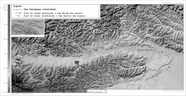
Fig.2. Simplified longitudinal profile of the Bolozivka
river channel, 1,2,3,4 – faults in sub-Quaternary basement.
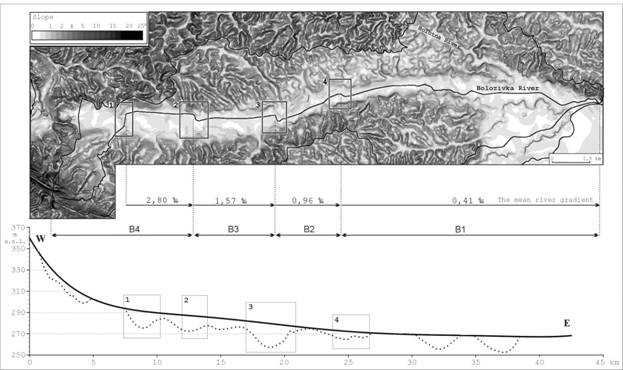
Fig.3. A- hypsometrical levels in the Bolozivka
river basin. Simulation of surfaces of the recognized terraces, Old Quaternary:
B- V lower Pleistocene terrace, San 2 glacier the Krukienice
interstadial: C- I interstadial
terrace, D- II interstadial terrace, E- III interstadial terrace, F- Holocenian
terrace.
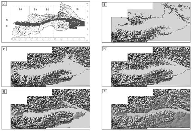
Fig.4. A- Disposition of interpolation points. B- Map of sub-Quaternary
basement based on the interpolation of thill of alluvium
on the background of contemporary relief of the Bolozivka
river valley.

Fig.5. Profile of the watershed with hypothetic sub-Quaternary basement
(intermittent line): 1,2- European San-Dnister, 3- Stryvigor-Bolozivka. In the framer the surfaces of interstadial terraces of the Bolozivka
river go out of the watershed, into the San river basin.